Maps from Antiquarian Book Shop
New Arrivals
More Photos
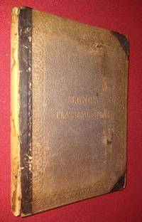
An Atlas of Classical Geography.with A Sketch of Classical Geography and other Additions: Containing Fifty-two Maps and Plans on Twenty-six Plates, with an Index of Places With a Sketch of Classical Geography
by Hughes, William ; George Long (editor)
- Condition
- Used - Good
- Published
- 1866
- Binding
- Hardcover
- Quantity Available
- 1
- Seller
-
Washington, District of Columbia, USA
- Item Price
-
$44.95
Show Details
Description:
Philadelphia: Henry C. Lea. Good. 1866. Hardcover. Text block unmarked, complete with all maps and securely stiched; binding lacks leather backstrip; cloth covered boards detached and worn at extremities. OCLC 15249384 This book measures 7 by 10 1/4 inches. Thirty-two pages of text, 17 double-page maps on guards (13.5" x 20"), 10 additional… Read more about this item Item Price
$44.95
More Photos
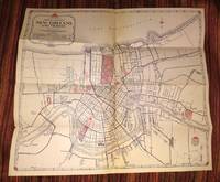
New Orleans and Vicinity
by AAA - American Automobile Association
- Condition
- Used - Very Good
- Published
- 1948
- Binding
- Map
- Quantity Available
- 1
- Seller
-
Washington, District of Columbia, USA
- Item Price
-
$14.95
Show Details
Description:
New Orleans: American Automobile Association. Very Good. 1948. Map. Clean and complete folding map of New Orleans and Vicinity measuring 18" X 16". Verso has text and a second more detailed map of Metropolitan New Orleans. A relic of the preferred mode of travel in mid-20th century America. A Triple A road map for… Read more about this item Item Price
$14.95

More Photos
PHILIPS HANDY GENERAL CENTENARY ATLAS OF THE WORLD
by Philip, George, F.R.G.S. (editor
- Condition
- Used - Very Good-
- Edition
- Fourth Edition
- Published
- 1934
- Binding
- Hardcover
- Quantity Available
- 1
- Seller
-
Washington, District of Columbia, USA
- Item Price
-
$149.94
Show Details
Description:
London: George Philip & Son, Ltd. Very Good-. 1934. Fourth Edition. Hardcover. Contents complete, no inscriptions - a date Jan 1939, maps all present and in very nice condition, only endpapers are foxxed. The maps are mounted on guards, so the folds are NOT worked into the binding. Secure in original green cloth binding, 2" piece… Read more about this item Item Price
$149.94

MAP OF THE CITY OF WASHINGTON - Location of Deaths for the Year Ending June 30, 1891 "Combined numbers show total deaths on each square. Deaths of white persons are shown by numbers in red. Those of colored persons by numbers in blue.
by [Large map with coloring]
- Condition
- Used - Very Good
- Edition
- First Edition
- Published
- 1891
- Binding
- Map
- Quantity Available
- 1
- Seller
-
Washington, District of Columbia, USA
- Item Price
-
$39.94
Show Details
Description:
Washington, DC: U.S. House of Representatives. Very Good. 1891. First Edition. Map. Report of the Commissioners of the District of Columbia for 1891; Original 1891 large map of Washington, DC, removed from the Report of the Commissioners of the District of Columbia for 1891. Measures 30" x 29", folded into 36 panels. Minor edgewear, some… Read more about this item Item Price
$39.94

MAP OF THE CITY OF WASHINGTON - Showing Location of Fatal Cases of Zymotic Diseases for the Year Ending June 30, 1891 Typhoid Fever, Malarial Fever, Scarlet Fever, Diptheria, Diarrheal Diseases
by [Large map with coloring]
- Condition
- Used - Very Good-
- Edition
- First Edition
- Published
- 1891
- Binding
- Map
- Quantity Available
- 1
- Seller
-
Washington, District of Columbia, USA
- Item Price
-
$39.94
Show Details
Description:
Washington, DC: U.S. House of Representatives. Very Good-. 1891. First Edition. Map. Report of the Commissioners of the District of Columbia for 1891; Original 1891 large map of Washington, DC, removed from the Report of the Commissioners of the District of Columbia for 1891. Measures 30" x 29", folded into 36 panels. Minor edgewear, some… Read more about this item Item Price
$39.94

Map of South Asia and Southeast Asia and parts of Central Asia
by Fischer, Hans
- Condition
- Used - Very Good
- Published
- 1914
- Binding
- Map
- Quantity Available
- 1
- Seller
-
Washington, District of Columbia, USA
- Item Price
-
$34.94
Show Details
Description:
Leipzig: Wagner and Debes. Very Good. 1914. Map. 1 pages; Large colour map measures 20" x 15.5" folded to 3.75" x 5.5" Four tiny marginal tears (not affecting map); one closed 2 inch tear at left edge (no loss of image). Vintage map of Central and South Asia, includes India, Tibet, Burma, Siam, French… Read more about this item Item Price
$34.94

Colour Map of ASIA from Zell's Popular Encyclopedia
by Bartholomew, John
- Condition
- Used - Very Good+
- Published
- 1876
- Binding
- Map
- Quantity Available
- 1
- Seller
-
Washington, District of Columbia, USA
- Item Price
-
$15.00
Show Details
Description:
Philadelphia: T. Ellwood Zell. Very Good+. 1876. Map. This excellent vintage printed colour map of Asia measures 17" by 12 5/8" Printing details from the bottom margin state Engraved & Printed in Colours - T. Ellwood Zell, Philadelphia - by J. Bartholomew. No date engraved in the plate, but mid to late 1870s from Zell's… Read more about this item Item Price
$15.00

GENERAL MAP of the UNITED STATES from Zell's Popular Encyclopedia
by Bartholomew, John
- Condition
- Used - Very Good+
- Published
- 1876
- Binding
- Map
- Quantity Available
- 1
- Seller
-
Washington, District of Columbia, USA
- Item Price
-
$15.00
Show Details
Description:
Philadelphia: T. Ellwood Zell. Very Good+. 1876. Map. This excellent vintage printed colour map of the United States measures 17" by 12 5/8" Printing details from the bottom margin state Engraved & Printed in Colours - T. Ellwood Zell, Philadelphia - by J. Bartholomew. No date engraved in the plate, but mid to late 1870s… Read more about this item Item Price
$15.00

Colour Map of NORTH AMERICA from Zell's Popular Encyclopedia
by Bartholomew, John
- Condition
- Used - Very Good+
- Published
- 1876
- Binding
- Map
- Quantity Available
- 1
- Seller
-
Washington, District of Columbia, USA
- Item Price
-
$15.00
Show Details
Description:
Philadelphia: T. Ellwood Zell. Very Good+. 1876. Map. This excellent vintage printed colour map of North America measures 17" by 12 5/8" Printing details from the bottom margin state Engraved & Printed in Colours - T. Ellwood Zell, Philadelphia - by J. Bartholomew. No date engraved in the plate, but mid to late 1870s from… Read more about this item Item Price
$15.00