Maps from biblioboy
New Arrivals

More Photos
The European Image and Mapping of America A.D. 1000-1600: The James Ford Bell Lectures Number 1
by Skelton, R. A. [introductory comments by John Parker]
- Condition
- Used - Fine
- Edition
- First Edition
- Published
- 1964
- Binding
- Paperback
- Quantity Available
- 1
- Seller
-
North Providence, Rhode Island, USA
- Item Price
-
$12.00
Show Details
Description:
no place: The Associates of the James Ford Bell Collection [University Of Minnesota]. Near Fine. 1964. First Edition. Softcover. First edition [no statement of printing]. Decorated golden wrappers [about 5.25" x 7.75"], saddle-stapled, 28 pages. Fine copy. bx298 Item Price
$12.00

More Photos
A Modern Pilgrim's Map of the British Isles, or More Precisely The Kingdom of Great Britain and Northern Ireland, and The Free Irish State
by C. E. Riddiford, National Geographic Society
- Condition
- Used - Very Good
- Published
- 1937
- Binding
- Map
- Quantity Available
- 1
- Seller
-
North Providence, Rhode Island, USA
- Item Price
-
$10.00
Show Details
Description:
Printed by A. Hoen Co. Baltimore MD for the National Gepgrpahic Society 1937. Beautifully illustrated map. Very good condition with 2 mall tears at the intersections of two folds at the bottom. Light toning, and minor staining to a couple of spots. SEE photos bx433E Item Price
$10.00
More Photos
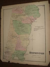
Rhode Island Map Hopkinton, Washington County 1870
by Beers, F.W.
- Condition
- Used - Good
- Published
- 1870
- Binding
- Map
- Quantity Available
- 1
- Seller
-
North Providence, Rhode Island, USA
- Item Price
-
$56.00
Show Details
Description:
Original 1870 Rhode Island Map. Hopkinton, Washington County, Rhode Island. Hand colored. The map including margins is 14.5 x 11.75 inches, 14 x 16.5 inches without margins, was taken from the Atlas of the State of Rhode Island and Providence Plantations by F.W. Beers. 1870. The map includes the communities of Barberville, Moscow, Grassy Pond, Rockville, Centreville, Ashville, Hope Valley,… Read more about this item Item Price
$56.00

More Photos
Lowell Thomas' War Map of the World
by Sunoco / Lowell Thomas
- Condition
- Used - Very Good
- Edition
- First Edition
- Published
- 0000
- Binding
- Map
- Quantity Available
- 1
- Seller
-
North Providence, Rhode Island, USA
- Item Price
-
$8.00
Show Details
Description:
Chicago: Sunoco / Rand McNally & Company no date [early-to-mid 1940s] About 19.5" x 26.75" unfolded / about 5" x 9" folded, maps are in color. Isenberg [Pennsylvania] Sunoco Service center stamp to the folded "cover" which also has a short black lines to its lower left corner. Very goodwith wear to edges of the folded cover. See photos. whb1 Item Price
$8.00

More Photos
Large 1920's French Auto Travel Map by Michelin & Co. "Carte Michelin De La France Auxerre Dijon No. 65 Michelin Map Auxerre-Dijon France" Translated Michelin Map France Auxerre Dijon No. 65 Michelin Map Auxerre-Dijon France
by Michelin & Co
- Condition
- Used - Very Good
- Edition
- First edition
- Published
- 1920
- Binding
- Pamphlet
- Quantity Available
- 1
- Seller
-
North Providence, Rhode Island, USA
- Item Price
-
$23.99
Show Details
Description:
France: Michelin & Co.. Very Good with No dust jacket as issued. 1920. Pamphlet. This antique French travel map is in very good collectible condition with the covers being age toned, dust soiled, and worn. The map has a trace of wear at the creases. A 44 By 20 Inch French Travel Map. See Photos; The map… Read more about this item Item Price
$23.99
More Photos
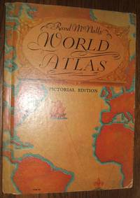
Rand McNally World Atlas Pictorial Edition
by Rand McNally
- Condition
- Used - Very Good
- Edition
- first thus
- Published
- 1934
- Binding
- Hardcover
- Quantity Available
- 1
- Seller
-
North Providence, Rhode Island, USA
- Item Price
-
$15.00
Show Details
Description:
Edge wear, wear to corners and spine ends. Filled with 64 pages of nice color maps and black and white photos. 8vo - over 7¾" - 9¾" tall. Hard Cover. ; Photographs, Maps .
wh 44 Item Price
$15.00