Topography from Deez Books
New Arrivals
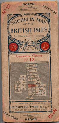
Michelin Map of Great Britain. No. 12 Carnarvon - Chester. Scale 3.15 miles to an inch
- Condition
- Used - Fair
- Jacket Condition
- No Jacket (as published)
- Binding
- Soft cover
- Quantity Available
- 1
- Seller
-
IPSWICH, Suffolk, GBR
- Item Price
-
$6.36
Show Details
Description:
London: Michelin Tyre Co. Ltd. Soft cover. Fair/No Jacket (as published). 4.5" x 10. A road map on linen of the north Wales area. Not dated but probably around 1920s (possibly 1923 or earlier as the roads are not numbered). There is wear/ handling and chipping to the card covers but the map shows some signs of… Read more about this item Item Price
$6.36

The Englsih Lake District
by M J B Baddeley
- Condition
- Used - Fair
- Jacket Condition
- No Jacket
- Edition
- 5th or later Edition
- Binding
- Hardcover
- Quantity Available
- 1
- Seller
-
IPSWICH, Suffolk, GBR
- Item Price
-
$10.17
Show Details
Description:
London: Ward Lock & Co Ltd. 5th or later Edition . Hardcover. Fair/No Jacket. 4.5" x 7. A 10th sixteenth revised edition of this guide book to parts of north west England around the Lake District. Not dated. Not dated but probably 1930s. Fold out maps are present but all show signs of repair. … Read more about this item Item Price
$10.17
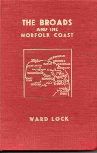
Red Guide. The Broads and Rivers of Norfolk including Great Yarmouth, Norwich, Cromer, Sheringham and the Coast
- Condition
- Used - Good
- Jacket Condition
- No Jacket
- Binding
- Hardcover
- Quantity Available
- 1
- Seller
-
IPSWICH, Suffolk, GBR
- Item Price
-
$3.18
Show Details
Description:
Ward Lock. Hardcover. Good/No Jacket. 4.75" x 7. Classic newer red guide to this part of eastern England. A slightly tired copy which has had the frontispiece map neatly removed (it is no longer present) No dust wrapper. All orders processed promptly and shipped from the UK.
Item Price
$3.18

The Maritime Alps and Their Seaboard. Vol. II
by The Author of Vera
- Condition
- Used - Good
- Jacket Condition
- No Jacket (as published)
- Published
- 1898
- Binding
- Half-Leather
- Quantity Available
- 1
- Seller
-
IPSWICH, Suffolk, GBR
- Item Price
-
$21.55
Show Details
Description:
Leipzig: Bernhard Tauchnitz, 1898. Half-Leather. Good/No Jacket (as published). 4.5" x 6.5. Volume 2 only of a two volume set looking at the history and topography of the southern part of the Alps mountain range. In red half leather binding which is worn on the hinges. There is evidence of previous ownership on the front free… Read more about this item Item Price
$21.55

Les Pays de Loire
by Yves Babonaux
- Condition
- Used - Fair
- Jacket Condition
- No Jacket (as published)
- Published
- 1973
- Binding
- Hardcover
- Quantity Available
- 1
- Seller
-
IPSWICH, Suffolk, GBR
- Item Price
-
$18.05
Show Details
Description:
Paris: Libraire Larousse, 1973. Hardcover. Fair/No Jacket (as published). 9" x 11.5. 120 pages. A guide to the Loire valley region of France. Clean and sound apart from the spine strip is missing. Text in French. All orders processed promptly and shipped from the UK.
Item Price
$18.05

Mountains of the Alps: Western Alps Vol. 1
by Robin G. Collomb
- Condition
- Used - Good
- Jacket Condition
- No Jacket (as published)
- Edition
- 1st Edition
- Published
- 1971
- Binding
- Hardcover
- ISBN
- 9780901516527
- Quantity Available
- 1
- Seller
-
IPSWICH, Suffolk, GBR
- Item Price
-
$24.79
Show Details
Description:
West Col Productions, 1971. 1st Edition . Hardcover. Good/No Jacket (as published). 96pp. A list (with some illustrations) of the mountains of the western Alps. (Volume one only). A well used book, some signs of handling and wear to the boards, a previous owner's signature on the front free end paper and multiple entries have… Read more about this item Item Price
$24.79

Geographia Motoring Age Map 30 Miles Around Leicester 2 Miles to 1 Inch
- Condition
- Used - Good
- Jacket Condition
- No Jacket (as published)
- Binding
- Soft cover
- Quantity Available
- 1
- Seller
-
IPSWICH, Suffolk, GBR
- Item Price
-
$6.36
Show Details
Description:
London: Geographia. Soft cover. Good/No Jacket (as published). A road map on cloth depicting an area around Leicester. The map is in good order but the cover is heavily worn and marked. Not dated but believed to be 1950s. All orders processed promptly and shipped from the UK.
Item Price
$6.36
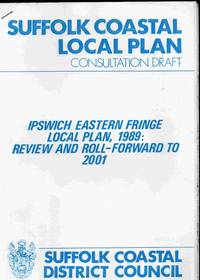
Suffolk Coastal Local Plan Consultation Draft. Ipswich Eastern Fringe Local Plan, 1989: review and Roll-Forward to 2001
- Condition
- Used - Good
- Jacket Condition
- No Jacket
- Published
- 1990
- Binding
- Soft cover
- Quantity Available
- 1
- Seller
-
IPSWICH, Suffolk, GBR
- Item Price
-
$6.36
Show Details
Description:
Woodbridge, Suffolk: Suffolk Coastal District Council, 1990. Soft cover. Good/No Jacket. Local authority planning discussion document. A4 stapled binding with maps. In clean and sound condition. Please email with any queries.
Item Price
$6.36

Suffolk Coastal Local Plan Consultation Draft. Woodbridge Area and Deben Peninsula
- Condition
- Used - Good
- Jacket Condition
- No Jacket
- Published
- 1990
- Binding
- Soft cover
- Quantity Available
- 1
- Seller
-
IPSWICH, Suffolk, GBR
- Item Price
-
$12.71
Show Details
Description:
Woodbridge, Suffolk: Suffolk Coastal District Council, 1990. Soft cover. Good/No Jacket. Local authority planning document. A4 comb-bound with maps. In clean and sound condition. Please email with any queries.
Item Price
$12.71
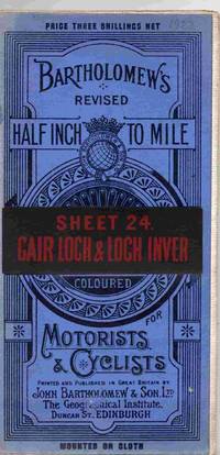
Bartholomew's Revised Half Inch To Mile Coloured for Motorists and Cyclists. Sheet 24. Cair Loch & Loch Inver
- Condition
- Used - Good
- Jacket Condition
- No Jacket (as published)
- Published
- 1922
- Binding
- Map
- Quantity Available
- 1
- Seller
-
IPSWICH, Suffolk, GBR
- Item Price
-
$7.63
Show Details
Description:
Edinburgh: John Bartholomew & Co, 1922. Map. Good/No Jacket (as published). A map mounted on cloth depicting this area of Scotland. Print date is B22. Some light wear / signs of handling but the map is in good order. All orders processed and shipped promptly from the UK, usually the same or next business day.… Read more about this item Item Price
$7.63
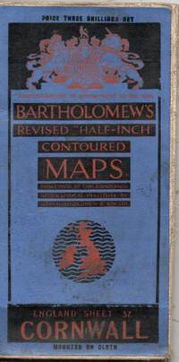
Bartholomew's Revised "Half-Inch" Contoured Maps. England Sheet 37. Cornwall
- Condition
- Used - Good
- Jacket Condition
- No Jacket (as published)
- Published
- 1927
- Binding
- Map
- Quantity Available
- 1
- Seller
-
IPSWICH, Suffolk, GBR
- Item Price
-
$7.63
Show Details
Description:
Edinburgh: John Bartholomew & Co, 1927. Map. Good/No Jacket (as published). A map, mounted on cloth, depicting an area of the south west England, print code is A27. Some wear through use. Previous owner's name and address on reverse of map. All orders processed and shipped promptly from the UK, usually the same or next business… Read more about this item Item Price
$7.63
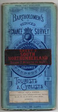
Bartholomew's Reduced Ordnance Survey. Sheet 2. South Northumberland. Scale 2 Miles to an Inch. Coloured for Tourists & Cyclists.
- Condition
- Used - Good
- Jacket Condition
- No Jacket (as published)
- Edition
- 1st Edition
- Binding
- Map
- Quantity Available
- 1
- Seller
-
IPSWICH, Suffolk, GBR
- Item Price
-
$6.36
Show Details
Description:
Edinburgh: John Bartholomew & Co. 1st Edition . Map. Good/No Jacket (as published). 4" x 7.5. A map mounted on cloth depicting an area of northern England, not dated but thought to be from around 1900. Some wear to the edges of the blue folded cover the map is clean an tidy and usable. Some damage to the… Read more about this item Item Price
$6.36
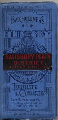
Bartholomew's New Reduced Survey. Salisbury Plain District. Scale 2 Miles to an Inch. Coloured for Tourists and Cyclists
- Condition
- Used - Fair
- Jacket Condition
- No Jacket (as published)
- Published
- 1915
- Binding
- Map
- Quantity Available
- 1
- Seller
-
IPSWICH, Suffolk, GBR
- Item Price
-
$6.36
Show Details
Description:
Edinburgh: John Bartholomew & Son Ltd, 1915. Map. Fair/No Jacket (as published). 4" x 7.5. A map on cloth depicting an area of England. Dated to 1915 from the date code A15. Some wear from usage but the map is on cloth and in tidy order. All orders processed and shipped promptly from the UK.… Read more about this item Item Price
$6.36

Bartholomew's Reduced Ordnance Survey. Sheet 13. Derby & Notts. Scale 2 Miles to an Inch. Coloured for Tourists & Cyclists.
- Condition
- Used - Good
- Jacket Condition
- No Jacket (as published)
- Edition
- 1st Edition
- Binding
- Map
- Quantity Available
- 1
- Seller
-
IPSWICH, Suffolk, GBR
- Item Price
-
$6.36
Show Details
Description:
Edinburgh: John Bartholomew & Co. 1st Edition . Map. Good/No Jacket (as published). 4" x 7.5. A map mounted on cloth depicting an area Midland'st England, not dated but thought to be from around 1900. Some wear to the edges of the blue folded cover the map is clean an tidy and usable. All orders processed and… Read more about this item Item Price
$6.36
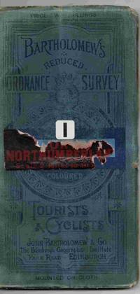
Bartholomew's Reduced Ordnance Survey. Sheet 1. Northumberland. Scale 2 Miles to an Inch. Coloured for Tourists & Cyclists.
- Condition
- Used - Good
- Jacket Condition
- No Jacket (as published)
- Edition
- 1st Edition
- Binding
- Map
- Quantity Available
- 1
- Seller
-
IPSWICH, Suffolk, GBR
- Item Price
-
$6.36
Show Details
Description:
Edinburgh: John Bartholomew & Co. 1st Edition . Map. Good/No Jacket (as published). 4" x 7.5. A map mounted on cloth depicting an area of northern England, not dated but thought to be from around 1900. Some wear to the edges of the blue folded cover the map is clean an tidy and usable. Some damage to the… Read more about this item Item Price
$6.36

Bartholomew's Reduced Ordnance Survey. Sheet 36. South Devon. Scale 2 Miles to an Inch. Coloured for Tourists & Cyclists.
- Condition
- Used - Good
- Jacket Condition
- No Jacket (as published)
- Edition
- 1st Edition
- Binding
- Map
- Quantity Available
- 1
- Seller
-
IPSWICH, Suffolk, GBR
- Item Price
-
$6.36
Show Details
Description:
Edinburgh: John Bartholomew & Co. 1st Edition . Map. Good/No Jacket (as published). 4" x 7.5. A map mounted on cloth depicting an area south west England, not dated but thought to be from around 1900. Some wear to the edges of the blue folded cover the map is clean an tidy and usable. All orders processed… Read more about this item Item Price
$6.36

Bartholomew's Reduced Ordnance Survey. Sheet 34. Dorset. Scale 2 Miles to an Inch. Coloured for Tourists & Cyclists.
- Condition
- Used - Good
- Jacket Condition
- No Jacket (as published)
- Edition
- 1st Edition
- Binding
- Map
- Quantity Available
- 1
- Seller
-
IPSWICH, Suffolk, GBR
- Item Price
-
$6.36
Show Details
Description:
Edinburgh: John Bartholomew & Co. 1st Edition . Map. Good/No Jacket (as published). 4" x 7.5. A map mounted on cloth depicting an area southern England, not dated but thought to be from around 1900. Some wear to the edges of the blue folded cover the map is clean an tidy and usable. All orders processed and… Read more about this item Item Price
$6.36

Bartholomew's Reduced Ordnance Survey. Sheet 33. New Forest & Isle of Wight. Scale 2 Miles to an Inch. Coloured for Tourists & Cyclists.
- Condition
- Used - Good
- Jacket Condition
- No Jacket (as published)
- Edition
- 1st Edition
- Binding
- Map
- Quantity Available
- 1
- Seller
-
IPSWICH, Suffolk, GBR
- Item Price
-
$6.36
Show Details
Description:
Edinburgh: John Bartholomew & Co. 1st Edition . Map. Good/No Jacket (as published). 4" x 7.5. A map mounted on cloth depicting an area southern England, not dated but thought to be from around 1900. Some wear to the edges of the blue folded cover the map is clean an tidy and usable. All orders processed and… Read more about this item Item Price
$6.36

Bartholomew's Reduced Ordnance Survey. Sheet 35. North Devon. Scale 2 Miles to an Inch. Coloured for Tourists & Cyclists.
- Condition
- Used - Good
- Jacket Condition
- No Jacket (as published)
- Edition
- 1st Edition
- Binding
- Map
- Quantity Available
- 1
- Seller
-
IPSWICH, Suffolk, GBR
- Item Price
-
$6.36
Show Details
Description:
Edinburgh: John Bartholomew & Co. 1st Edition . Map. Good/No Jacket (as published). 4" x 7.5. A map mounted on cloth depicting an area south west England, not dated but thought to be from around 1900. Some wear to the edges of the blue folded cover the map is clean an tidy and usable. All orders processed… Read more about this item Item Price
$6.36

Bartholomew's Reduced Ordnance Survey. Sheet 30. Surrey. Scale 2 Miles to an Inch. Coloured for Tourists & Cyclists.
- Condition
- Used - Good
- Jacket Condition
- No Jacket (as published)
- Edition
- 1st Edition
- Binding
- Map
- Quantity Available
- 1
- Seller
-
IPSWICH, Suffolk, GBR
- Item Price
-
$6.36
Show Details
Description:
Edinburgh: John Bartholomew & Co. 1st Edition . Map. Good/No Jacket (as published). 4" x 7.5. A map mounted on cloth depicting an area south west of London, England, not dated but thought to be from around 1900. Some wear to the edges of the blue folded cover the map is clean an tidy and usable. … Read more about this item Item Price
$6.36