Europe from Donald Heald Rare Books
New Arrivals

More Photos
To His Royal Highness the Duke of Cambridge, K. G. &c. This Map of the Physical Divisions of Germany Exhibiting the Post Roads, Canals, &c. Constructed from Original Materials..
by ARROWSMITH, Aaron (1750-1823)
- Condition
- Used
- Published
- 1812
- Quantity Available
- 1
- Seller
-
New York, New York, USA
- Item Price
-
$1,200.00
Show Details
Description:
London: Aaron Arrowsmith, 1812. Copper engraved case map in six sections, dissected and laid on linen. Overall, if joined, 52 1/2 x 77 3/4 inches. Minor soiling at edges. First issue of Arrowsmith's highly detailed depiction of Germany made during the Napoleonic Wars
The Duke of Cambridge, to whom Arrowsmith dedicated this map, was the 7th son of… Read more about this item Item Price
$1,200.00

More Photos
Commune de Nades
by [MANUSCRIPT MAP OF NADES, FRANCE] - M. THIBAUDIN (?)
- Condition
- Used
- Published
- 1827
- Quantity Available
- 1
- Seller
-
New York, New York, USA
- Item Price
-
$250.00
Show Details
Description:
Nades, 1827. Watercolor, pen and ink, and pencil. Paper dissected and backed on brown linen. Two sheets, dissected and backed on linen. Sheet size: 26 3/8 x 40 1/8 inches. These are two hand-drawn maps of the small village of Nades in the Auvergne region in central France on folded, linen backed and dissected sheets done in 1827. They… Read more about this item Item Price
$250.00
![Nona Europe Tabula [The Balkans] [from:] Cosmographia](https://d3525k1ryd2155.cloudfront.net/h/195/337/1297337195.1.m.jpg)
Nona Europe Tabula [The Balkans] [from:] Cosmographia
by PTOLEMAEUS, Claudius (c.90-170 AD, Cartographer), ANGELUS, Jacobus (c.1360-1411, Translator), GERMANUS, Donnus Nicolaus (c.1420-1490, Cartographer, Editor), SCHNITZER, Johannes (fl.1475-1515, Woodcutter)
- Condition
- Used
- Published
- 1482
- Binding
- Map
- Quantity Available
- 1
- Seller
-
New York, New York, USA
- Item Price
-
$24,000.00
Show Details
Description:
Ulm, Germany: Lienhart Holle, 1482. Map. Double-page woodcut map with fine original hand-coloring and Latin place names in letterpress type. Carved gold leaf frame with Amiran anti-reflective archival glass with UV protection. Scale: c.1:4,000,000. Sheet: (15 1/2 x 22 1/4 inches). Frame: (25 1/2 x 32 1/4 inches). A beautiful incunable map of the Balkans, including Constantinople, from the… Read more about this item Item Price
$24,000.00
![Prima Asie Tabula [Türkiye] [from:] Cosmographia](https://d3525k1ryd2155.cloudfront.net/h/337/336/1297336337.1.m.jpg)
Prima Asie Tabula [Türkiye] [from:] Cosmographia
by PTOLEMAEUS, Claudius (c.90-170 AD, Cartographer), ANGELUS, Jacobus (c.1360-1411, Translator), GERMANUS, Donnus Nicolaus (c.1420-1490, Cartographer, Editor), SCHNITZER, Johannes (fl.1475-1515, Woodcutter)
- Condition
- Used
- Published
- 1482
- Binding
- Map
- Quantity Available
- 1
- Seller
-
New York, New York, USA
- Item Price
-
$24,000.00
Show Details
Description:
Ulm, Germany: Lienhart Holle, 1482. Map. Double-page woodcut map with fine original hand-coloring and Latin place-names in letterpress type. Carved gold leaf frame with Amiran anti-reflective archival glass with UV protection. Scale: c.1:4,000,000. Sheet (15 1/2 x 22 1/4 inches). Frame: (25 1/2 x 32 1/4 inches). This is one of the earliest obtainable maps of Türkiye. A beautiful… Read more about this item Item Price
$24,000.00
![Tabula Moderna Hispanie [Iberian Peninsula] [from:] Cosmographia](https://d3525k1ryd2155.cloudfront.net/h/960/335/1297335960.1.m.jpg)
Tabula Moderna Hispanie [Iberian Peninsula] [from:] Cosmographia
by PTOLEMAEUS, Claudius (c.90-170 AD, Cartographer), ANGELUS, Jacobus (c.1360-1411, Translator), GERMANUS, Donnus Nicolaus (c.1420-1490, Cartographer, Editor), SCHNITZER, Johannes (fl.1475-1515, Woodcutter)
- Condition
- Used
- Published
- 1482
- Binding
- Map
- Quantity Available
- 1
- Seller
-
New York, New York, USA
- Item Price
-
$35,000.00
Show Details
Description:
Ulm, Germany: Lienhart Holle, 1482. Map. Double-page woodcut map with fine original hand-coloring and Latin place names in letterpress type. Carved gold leaf frame with Amiran anti-reflective archival glass with UV protection. Scale: c.1:4,000,000. Sheet: (15 1/2 x 22 1/4 inches). Frame: (25 1/2 x 32 1/4 inches). A beautiful incunable map of Spain and Portugal from the 1482… Read more about this item Item Price
$35,000.00
![Tertia Europae Tabula [France and Belgium] [from:] Cosmographia](https://d3525k1ryd2155.cloudfront.net/h/889/335/1297335889.1.m.jpg)
Tertia Europae Tabula [France and Belgium] [from:] Cosmographia
by PTOLEMAEUS, Claudius (c.90-170 AD, Cartographer), ANGELUS, Jacobus (c.1360-1411, Translator), GERMANUS, Donnus Nicolaus (c.1420-1490, Cartographer, Editor), SCHNITZER, Johannes (fl.1475-1515, Woodcutter)
- Condition
- Used
- Published
- 1482
- Binding
- Map
- Quantity Available
- 1
- Seller
-
New York, New York, USA
- Item Price
-
$30,000.00
Show Details
Description:
Ulm, Germany: Lienhart Holle, 1482. Map. Double-page woodcut map with fine original hand-coloring and Latin place names in letterpress. Carved gold leaf frame with Amiran anti-reflective archival glass with UV protection. Scale: c.1:4,000,000. Sheet: (15 1/2 x 22 1/4 inches). Frame: (25 1/2 x 32 1/4 inches). A beautiful incunable map of Western Europe from the 1482 Ulm edition… Read more about this item Item Price
$30,000.00
![[18th century map of Paris] Nouveau Plan Routier de la Ville et Faubourgs de Paris](https://d3525k1ryd2155.cloudfront.net/h/039/243/1260243039.1.m.jpg)
[18th century map of Paris] Nouveau Plan Routier de la Ville et Faubourgs de Paris
by HENAUT & RAPILLY (publishers)
- Condition
- Used
- Published
- 1773
- Quantity Available
- 1
- Seller
-
New York, New York, USA
- Item Price
-
$750.00
Show Details
Description:
[Paris], 1773. Engraved plan, cut into sections, but now mounted on a single sheet of card. Image size: 20 1/4 x 31 1/2 inches. Lovely pre-Revolution map of Paris.
Fascinating 1773 map of Paris that locates all major buildings and parks, with an extensive index. Item Price
$750.00
![[Burgundy] Partie Septrionale Du Duche De Bourgogne Par Guillaume Del 'Isle de l' Academie Royale des Sciences.[and] Partie Meridonale du Duche de Bourgogne](https://d3525k1ryd2155.cloudfront.net/h/265/955/1255955265.2.m.jpg)
More Photos
[Burgundy] Partie Septrionale Du Duche De Bourgogne Par Guillaume Del 'Isle de l' Academie Royale des Sciences.[and] Partie Meridonale du Duche de Bourgogne
by DE L'ISLE, Guillaume (1675-1726/ Cóvens & Mortier
- Condition
- Used
- Published
- 1742
- Quantity Available
- 1
- Seller
-
New York, New York, USA
- Item Price
-
$650.00
Show Details
Description:
Amsterdam: Cóvens & Mortier, 1742. Engraved with period outline colour. Discolouration at center fold. Collection stamp on verso. A handsome, two-sheet map of Burgundy.
This pair of maps of the ancient kingdom of Burgundy comes from a Dutch edition of De L'Isle's work entitled, Atlas Nouveau, Contenant Toutes Les Parties Du Monde, Ou sont exactement Remarquées les Empires,… Read more about this item Item Price
$650.00

A New & Exact Map of the Electorate of Brunswick-Lunenburg and ye rest of ye Kings Dominions in Germany, Very much Improved by ye kind Assistance of severall Curious Gentlemen, natives of those Countries. To His Most Sacred Majesty George King of Great Britain, France and Ireland, Elector of Brunswick-Lunenburg &c
by MOLL, Herman (fl. 1678-1732)
- Condition
- Used
- Published
- 1740
- Quantity Available
- 1
- Seller
-
New York, New York, USA
- Item Price
-
$1,500.00
Show Details
Description:
London: Herman Moll and Philip Overton, 1740. Hand-coloured engraving. Creased vertically where map was folded into atlas. Moll's Map of King George I's dominions in Germany.
Brunswick-Lunenburg had been ruled by one family, descendants of Guelph, since the 13th century. One branch of this ancient family brought forth the Hanoverian Kings of Great Britain. It was the first… Read more about this item Item Price
$1,500.00

Les Provinces Des Pays-Bas Catholiques ou A Most Exact Map of Flanders or Austrian Netherlands & c.
by MOLL, Herman (fl. 1678-1732)
- Condition
- Used
- Published
- 1715
- Quantity Available
- 1
- Seller
-
New York, New York, USA
- Item Price
-
$675.00
Show Details
Description:
London: Sold by H. Moll over against Devereux Court ... D. Midwinter ... & T. Bowles, 1715. Copper-engraving, with outline period hand-colouring, on two joined sheets, overall sheet size: 24 3/4 x 41inches. Good condition apart from a few small expertly repaired tears. A fine large format map inspired by the War of the Spanish Succession, and showing the… Read more about this item Item Price
$675.00

More Photos
Suevia Universa IX Tabulæs Delineata
by MICHAL, Jacques
- Condition
- Used
- Published
- 1725
- Quantity Available
- 1
- Seller
-
New York, New York, USA
- Item Price
-
$2,500.00
Show Details
Description:
Augsburg: M. Seutter, 1725. Nine linen-backed dissected panels, differing slightly in size, but averaging 20 x 21 inches, which if joined would form a map of approximately 60 x 63 inches, with mapseller's label of 'Goujon, Paris' on back of each panel, modern black cloth box, black morocco lettering piece. This is one of the finest maps of modern-day… Read more about this item Item Price
$2,500.00

More Photos
Partes confines Trium Magnorum Imperiorum Austriaci Russici et Osmanici
by RHODE, Johann Christoph (1713-1786)
- Condition
- Used
- Published
- 1785
- Quantity Available
- 1
- Seller
-
New York, New York, USA
- Item Price
-
$4,500.00
Show Details
Description:
[Berlin: Royal Prussian Academy of Sciences], 1785. Engraved case map, full period hand colouring, dissected and linen-backed as issued. Housed in period green morocco backed case, with armorial bookplate of the Borghese family. Highly-detailed 18th century large-scale map of the Black Sea region: fine example from the celebrated library of the Borghese family.
Centered on the Black Sea,… Read more about this item Item Price
$4,500.00

More Photos
A New & Exact Map of the Electonate of Brunswick-Lunenburg and ye rest of ye Kings Dominion in Germany
by MOLL, Herman (1654-1732)
- Condition
- Used
- Published
- 1730
- Quantity Available
- 1
- Seller
-
New York, New York, USA
- Item Price
-
$850.00
Show Details
Description:
London: H. Moll, T. & J. Bowles, P. Overton & J. King, 1730. Copper-engraved map, with original outline colour, in excellent condition. A magnificent map celebrating the ascension of the House of Hanover to the British throne, depicting the new King's German possessions.
Herman Moll first printed this map immediately after George I came to the throne of… Read more about this item Item Price
$850.00
![[English Channel] Canalis inter Angliæ et Galliæ Littora. Pasecaert van 't Canaal tusschen Engeland en Vranckryck](https://d3525k1ryd2155.cloudfront.net/h/196/083/66083196.0.m.jpg)
More Photos
[English Channel] Canalis inter Angliæ et Galliæ Littora. Pasecaert van 't Canaal tusschen Engeland en Vranckryck
by RENARD, Louis (1678-1746)
- Condition
- Used
- Published
- 1739
- Quantity Available
- 1
- Seller
-
New York, New York, USA
- Item Price
-
$2,400.00
Show Details
Description:
[Amsterdam: Renard, 1739. Copper-engraved sea chart, with full orginal colour, in very good condition. A highly decorative sea chart of the English Channel, by the master-engraver Renard.
The marine atlases of 17th and 18th century Holland were best sellers. The nation that led the world in overseas commerce also led in the arts of engraving and cartography. Plus,… Read more about this item Item Price
$2,400.00

More Photos
Denbighshire
by SPEED, John (c. 1552-1629)
- Condition
- Used
- Published
- 1713
- Quantity Available
- 1
- Seller
-
New York, New York, USA
- Item Price
-
$500.00
Show Details
Description:
London: Henry Overton, Bassett & Chiswell, 1713. Copper-engraved map, with full modern colour, very large marings, in very good condition, except for a stain at the bottom edge, well away from the image. A highly decorative map of Denbighshire by one of the greatest English cartographers
Denbighshire in Wales, clearly a mountainous region, was surveyed by Christopher Saxton,… Read more about this item Item Price
$500.00
![[Denmark] Carte de Detroit du Sond Contenant les Costes de L'Isle de Zélande Comprises ente Nicopen et L'Isle de Meun, et Celles du Schonen Depuis la Pointe de Kol, jusqu'a Valsterbon. Levée et Gravée Par Ordre du Roy](https://d3525k1ryd2155.cloudfront.net/h/378/081/66081378.0.m.jpg)
More Photos
[Denmark] Carte de Detroit du Sond Contenant les Costes de L'Isle de Zélande Comprises ente Nicopen et L'Isle de Meun, et Celles du Schonen Depuis la Pointe de Kol, jusqu'a Valsterbon. Levée et Gravée Par Ordre du Roy
by MORTIER, Pierre (1661-1711)
- Condition
- Used
- Published
- 1693
- Quantity Available
- 1
- Seller
-
New York, New York, USA
- Item Price
-
$1,250.00
Show Details
Description:
Paris [Amsterdam: Pierre Mortier], 1693. Engraved with full, period colour and gold embellishment. A magnificent 17th century sea chart of Copenhagen and surrounding regions.
This large scale, beautifully coloured coastal chart of the coast of Sjaelland (Zéland), Denmark and the south-western tip of Sweden comes from Le Neptune François, a lavish collection of charts produced collaboratively by Hubert… Read more about this item Item Price
$1,250.00
![[Normandy] Le Duché et Gouvernement de Normandie divisée en Haute et Basse Normandie en divers Pays; et par evêchez, avec le Gouvernement General du Havre de Grace](https://d3525k1ryd2155.cloudfront.net/h/580/079/66079580.0.m.jpg)
More Photos
[Normandy] Le Duché et Gouvernement de Normandie divisée en Haute et Basse Normandie en divers Pays; et par evêchez, avec le Gouvernement General du Havre de Grace
by JAILLOT, Alexis Hubert (1632-1712), after Nicolas SANSON (1600-1667)
- Condition
- Used
- Published
- 1696
- Quantity Available
- 1
- Seller
-
New York, New York, USA
- Item Price
-
$2,750.00
Show Details
Description:
Paris: Alexis Hubert Jaillot, 1696. Copper-engraved map, with full original colour and gold embellishment, in excellent condition. A stunning map of Normandy by Alexis Jaillot, an exceptional example with gilt embellishments.
One of the most important figures in French cartography, Nicolas Sanson initiated the great school of French geographers. Born in Abbeville in 1600, Sanson established his first… Read more about this item Item Price
$2,750.00
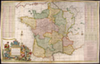
More Photos
A New and Exact Map of France Dividid into all its Provinces and Acquisitions, according to the Newest Observations, and that accurate Survey made by the King's Command by Mr. Picar and de la Hire, with the Post Roads and the Computed Leagues from Town to Town, and the Passes of the Pirenean Mountains and many other Remarcks &c
by MOLL, Herman (1654-1732)
- Condition
- Used
- Published
- 1740
- Quantity Available
- 1
- Seller
-
New York, New York, USA
- Item Price
-
$750.00
Show Details
Description:
London: J. Bowles, P. Overton, T. Bowles, John King, 1740. Hand-coloured engraving. Repaired loss to bottom left corner outside neat line with facsimile border. Trimmed to platemark in places in top margin. Three vertical creases where map was folded into atlas. Multiple creases parallel to center fold. Splits in vertical folds have been rebacked. A superb map of France… Read more about this item Item Price
$750.00

More Photos
A Correct Map Shewing all Towns, Villages, Roads the Seats of ye Nobility and Gentry, Wth. Whatever else is remarkable within 30 miles of London
by PRICE, Charles (fl.1680-1720)
- Condition
- Used
- Published
- 1712
- Quantity Available
- 1
- Seller
-
New York, New York, USA
- Item Price
-
$2,500.00
Show Details
Description:
London: Charles Price, 1712. Copper-engraved map, with full original colour, printed on laid paper, in excellent condition. A very fine impression of Charles Price's rare map of London and its environs, which became one of the most copied maps in England.
Charles Price was a land surveyor and mapmaker, whose maps were nearly all collaborative efforts. After his… Read more about this item Item Price
$2,500.00