Topography from George Jeffery Books
New Arrivals

The Parish Register of Titsey, Co. Surrey
by Bannerman W. Bruce [ Transcribed and Edited By ]
- Condition
- Used - Very Good
- Published
- 1909
- Binding
- Hardcover
- Quantity Available
- 1
- Seller
-
CHESHUNT, Hertfordshire, GBR
- Item Price
-
$158.56
Show Details
Description:
London, 1909. Book measures 23x15.cm. xxiv, 63pp, 3 plates. Bound in original publishers red cloth, with gilt crest and lettering. Cloth lightly rubbed, minor wear on edges. Binding in good clean firm condition. Internally, pages clean. A nice clean copy. Cloth. Very Good. 8vo. Item Price
$158.56

100 Years in the Wilderness the Story of an Uncommon Road
by Green Tim
- Condition
- Used - Very Good Plus
- Published
- 1997
- Binding
- Hardcover
- ISBN
- 9780953149704
- Quantity Available
- 1
- Seller
-
CHESHUNT, Hertfordshire, GBR
- Item Price
-
$69.77
Show Details
Description:
Harrow: Wilderness Publishing , 1997. Book measures 25x18.cm. 102pp, illustrated throughout. Bound in original publishers faux green leather, with gilt lettering. Binding in very good clean firm condition. Internally, pages clean. A nice clean copy. . Signed by Author. Hardcover. Very Good Plus. 8vo. Item Price
$69.77
![The Early History of Woodstock Manor and Its Environs, in Bladon, Hensington, New Woodstock, Blenheim; with Later Notices [ with the Second Supplement Volumes ]](https://d3525k1ryd2155.cloudfront.net/h/600/920/1595920600.0.m.jpg)
The Early History of Woodstock Manor and Its Environs, in Bladon, Hensington, New Woodstock, Blenheim; with Later Notices [ with the Second Supplement Volumes ]
by Marshall Edward
- Condition
- Used - Near Very Good
- Published
- 1873
- Binding
- Hardcover
- Quantity Available
- 1
- Seller
-
CHESHUNT, Hertfordshire, GBR
- Item Price
-
$221.99
Show Details
Description:
Oxford and London: James Parker and Co, 1873. 2 volumes. Books measure 19.5x13.5.cm. & 18.5x12.5.cm. Collation, xvi, 474, [8]pp, folding plan, viii, 121,[3]pp, folding plan. First volume bound in original publishers cloth, with gilt lettering. Cloth rebacked, retaining most of the original spine. Binding in very good clean firm condition. Internally, previous owners name inscription. Pages and plan in very… Read more about this item Item Price
$221.99

More Photos
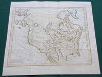
A Map of North America with the European Settlements & Whatever Else is Remarkable in ye West Indies.
by Richard William Seale.
- Condition
- Used - Very Good
- Published
- 1745
- Quantity Available
- 1
- Seller
-
CHESHUNT, Hertfordshire, GBR
- Item Price
-
$951.38
Show Details
Description:
London, 1745. Uncoloured map. Map measures 46.5x37.5.cm, plus narrow margin. A good clean uncoloured map. . Very Good. Item Price
$951.38

More Photos
Meridionale divisa ne suoi principali Stati. Venezia,
by Zatta, Antonio
- Condition
- Used - Very Good
- Published
- 1784
- Quantity Available
- 1
- Seller
-
CHESHUNT, Hertfordshire, GBR
- Item Price
-
$158.56
Show Details
Description:
Venice: Presso Antonio Zatta, e Figli, Venice, 1784. Coloured. Map measures 40x30.cm. Some light dust, dirt marking. Map in good condition. . Very Good. Item Price
$158.56

More Photos
Carte des Isles Sandwich. Plan de la Baye de Karakakooa
by Bonne, Rigobert
- Condition
- Used - Near Very Good
- Published
- 1779
- Quantity Available
- 1
- Seller
-
CHESHUNT, Hertfordshire, GBR
- Item Price
-
$475.69
Show Details
Description:
Paris, 1779. Map measures 46x27.cm, plus margin. Some minor repairs on edges, folds showing light wear, minor staining. Map in good condition. . Near Very Good. Item Price
$475.69

More Photos
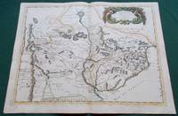
A New and Accurate Map of Peru, and the Country of the Amazones. Drawn from the most authentick French Maps
by Bowen Emanuel
- Condition
- Used - Very Good
- Published
- 1747
- Quantity Available
- 1
- Seller
-
CHESHUNT, Hertfordshire, GBR
- Item Price
-
$221.99
Show Details
Description:
London, 1747. Hand coloured map. Map measures 42x34.5.cm, plus margin. Map in good clean conition. Attractive and well-engraved map with much detail focused on the Amazon River. Covers the region from Ecuador south well into Chili. . Very Good. Item Price
$221.99

More Photos
Carte des Lacs du Canada pour Servir a l'Histoire Generale de Voyages
by Bellin, Jacques Nicolas
- Condition
- Used - Very Good
- Published
- 1757
- Quantity Available
- 1
- Seller
-
CHESHUNT, Hertfordshire, GBR
- Item Price
-
$570.82
Show Details
Description:
Publication: Prevost's Histoire Generale des Voyages, 1757. Hand coloured. Map measures 28x19.5.cm, plus margin. Map has some minor light wear. Map in good condition. French & Indian War period map depicting the five Great Lakes.. Very Good. Item Price
$570.82

More Photos
Cracovia sedes Regia obsessa (...) anno 1655
by Pufendorf Samuel
- Condition
- Used - Good Plus
- Published
- 1700
- Quantity Available
- 1
- Seller
-
CHESHUNT, Hertfordshire, GBR
- Item Price
-
$234.67
Show Details
Description:
Erik J. Dahlberg, 1700. View measures 56x31.cm. Print strengthened on edges and folds, minor loss in a few places, some minor stain marking. Print in good condition.. Good Plus. Item Price
$234.67

More Photos
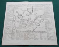
Carte Generale de la Pologne avec tous les Etats qui en Dependent
by Rizzi-Zannoni, Giovanni Antonio
- Condition
- Used - Very Good
- Published
- 1775
- Quantity Available
- 1
- Seller
-
CHESHUNT, Hertfordshire, GBR
- Item Price
-
$253.70
Show Details
Description:
Paris, 1775. Partially coloured. Map measures 46x31.cm, plus margin. Some minor staining on margin. Map in good clean condition. . Very Good. Item Price
$253.70

More Photos
Plan du port de Veracruz dresse par Don Bernardo
by Von Humboldt Alexander
- Condition
- Used - Very Good
- Published
- 1798
- Quantity Available
- 1
- Seller
-
CHESHUNT, Hertfordshire, GBR
- Item Price
-
$348.84
Show Details
Description:
Madrid: Dirección de Hidrografía, 1798. Map measures 28x21.cm, plus margin. Some dust, dirt marking to margin. Map in good condition. . Very Good. Item Price
$348.84
More Photos
Le Paraguay Tire des Relations les Plus Recentes, 1668
by Sanson. Mariette
- Condition
- Used - Very Good
- Published
- 1668
- Quantity Available
- 1
- Seller
-
CHESHUNT, Hertfordshire, GBR
- Item Price
-
$348.84
Show Details
Description:
Paris: Cartes Generales de Toutes les Parties du Monde.., 1668. Hand coloured. Map measures 55x40.cm, plus margin. Some light surface wear or dust marking. Map in good condition. Boldly engraved map of the region of present day Paraguay, Uruguay, northern Argentina, and parts of Chile and Brazil. The Rio de la Plata is the main feature of the map, which… Read more about this item Item Price
$348.84
More Photos
Carte des parties nord et ouest de L'Amerique dressee d'apres les relations les plus authentiques par M... en 1764, Nouvelle edition reduite par M. de Vaugondy en 1772
by Denis Diderot Didier Robert de Vaugondy
- Condition
- Used - Near Very Good
- Published
- 1772
- Quantity Available
- 1
- Seller
-
CHESHUNT, Hertfordshire, GBR
- Item Price
-
$190.28
Show Details
Description:
Paris, 1772. Partially coloured. Map measures 38x29.5.cm, plus margin. Some minor light spotting, light wear to folds. Map in good condition. . Near Very Good. Item Price
$190.28
More Photos
Carte Particuliere Du Fleuve Saint Louis : Dressee Sur Les Lieux Avec Les Noms Des Sauvages Du Pais.
by Chatelain Henri Abraham
- Condition
- Used - Very Good
- Published
- 1719
- Quantity Available
- 1
- Seller
-
CHESHUNT, Hertfordshire, GBR
- Item Price
-
$634.25
Show Details
Description:
Paris, 1719. Map measures 46x40.cm. Map in very good clean condition. . Very Good. Item Price
$634.25

More Photos
L'Amerique meridionale divise´e en ses principaux Etats
by Janvier, Jean Denis.
- Condition
- Used - Very Good
- Published
- 1782
- Quantity Available
- 1
- Seller
-
CHESHUNT, Hertfordshire, GBR
- Item Price
-
$158.56
Show Details
Description:
Paris: Paris : Chez Lattre, 1782. Coloured. Map measures 44x30.cm, plus margin. Some light dust,dirt marking. Map in good clean condition. . Very Good. Item Price
$158.56

More Photos
Carte du Perou ou se Trouvent les Audiences de Quito, Lima et la Plata. Projettee et Assujettie aux Observations Astronomiques
by Bonne/Lattre
- Condition
- Used - Very Good
- Published
- 1780
- Quantity Available
- 1
- Seller
-
CHESHUNT, Hertfordshire, GBR
- Item Price
-
$253.70
Show Details
Description:
Paris, 1780. Coloured map. Map measures 32x44.cm, plus margin. A nice clean coloured map. . Very Good. Item Price
$253.70
More Photos
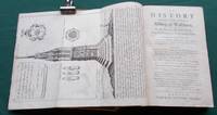
The History of the Ancient Town, and once Famous Abbey, of Waltham, in the County of Essex, from the Foundation to the Present Time. To which is added The History of Abbies, abridg'd, from the year 977 to their Dissolution and down to the Reign of Queen
by Farmer J.
- Condition
- Used - Good
- Edition
- First Edition
- Published
- 1735
- Binding
- Hardcover
- Quantity Available
- 1
- Seller
-
CHESHUNT, Hertfordshire, GBR
- Item Price
-
$183.93
Show Details
Description:
London: Printed for the Author, 1735. Book measures 19.5x13.cm. Collation, title, iv, iv, [10],197,[10],237pp, complete with 9 plates of which 4 are folding. Bound in early calf, boards have gilt lines, gilt corner peices, full gilt edges. Lacking spine, both boards detaches. Internally, previous owners bookplate, front endpaper torn, large folding plate split on folds, with repair. Generally, pages and… Read more about this item Item Price
$183.93

More Photos
In Castle and Cabin or Talks in Ireland in 1887
by Pellew George
- Condition
- Used - Very Good
- Edition
- Third Edition
- Published
- 1889
- Binding
- Hardcover
- Quantity Available
- 1
- Seller
-
CHESHUNT, Hertfordshire, GBR
- Item Price
-
$95.14
Show Details
Description:
New York & London: G. P. Putnam's Sons. The Knickerbocker Press , 1889. Book measures 21x15.cm. vii, 309pp, folding map. Bound in period red cloth, with paper title label. Cloth lightly rubbed, library number on spine. Binding in very good clean firm condition. Internally, very occasional library stamp or mark, [ about 5 in all ]. map nicked on margin,… Read more about this item Item Price
$95.14
![United States Geological Survey to the Secretary of the Interior 1897-98 [ Nineteenth Annual Report ]](https://d3525k1ryd2155.cloudfront.net/h/759/532/1593532759.0.m.jpg)
More Photos
United States Geological Survey to the Secretary of the Interior 1897-98 [ Nineteenth Annual Report ]
by Walcott Charles D.
- Condition
- Used - Near Very Good
- Published
- 1899
- Binding
- Hardcover
- Quantity Available
- 1
- Seller
-
CHESHUNT, Hertfordshire, GBR
- Item Price
-
$120.51
Show Details
Description:
Washington: Government Printing Office, 1899. Book measures 29.5x20.5.cm. viii,, 814pp, 118 plates,some folding, some coloured. Bound in original publishers cloth, with gilt crest and lettering. Cloth rubbed, some wear loss, inner fron hinge joint split, but holding, library label on top board. Binding in good condition. Internally, occasional library stamp, [ about 20 in all ]. Pages and plates in… Read more about this item Item Price
$120.51
![United States Coast Survey, Showing the Progress of the Survey During the Year 1875 , [ 41 Maps, Plates ]](https://d3525k1ryd2155.cloudfront.net/h/723/532/1593532723.0.m.jpg)
More Photos
United States Coast Survey, Showing the Progress of the Survey During the Year 1875 , [ 41 Maps, Plates ]
by Anon
- Condition
- Used - Near Very Good
- Published
- 1878
- Binding
- Hardcover
- Quantity Available
- 1
- Seller
-
CHESHUNT, Hertfordshire, GBR
- Item Price
-
$475.69
Show Details
Description:
Washington: Government Printing Office, 1878. Book measures 29.5x23.cm. xx, 412,[1]pp, 41 plates of which 22 are folding maps. Bound in original publishers cloth. Cloth rubbed, worn, spine sellotaped, library label on top board. Internally, occasional library stamp, [ about 10 in all ], maps free of stamps, light tanning to pages, maps. Pages and maps in good clean condition.… Read more about this item Item Price
$475.69