Maps And Atlases from
New Arrivals

More Photos
A New & Complete Map of The City of Boston, With Part of Charlestown, Cambridge and Roxbury...by G.W. Boynton for N. Dearborn
- Condition
- Used - VG, very minor staining and tenderness at fold corners with minor wear holes of lilliputian dimensions, bright and vibrant color
- Published
- 1844
- Quantity Available
- 1
- Seller
-
Columbia, Pennsylvania, USA
- Item Price
-
$1,000.00
Show Details
Description:
Boston: N. Dearborn, 1844. VG, very minor staining and tenderness at fold corners with minor wear holes of lilliputian dimensions, bright and vibrant colors. Folded cloth case with "Dearborn's Map of Boston in gilt embossing on cover. Unfolds to 18.4" x 15.5" An exquisite copy of this treasure. Item Price
$1,000.00

More Photos
Panorama of the Hudson River from New York to Albany, Drawn from Nature & Engraved by William Wade
by Wade, William
- Condition
- Used - VG, typical soiling and age-toning, folds are strong overall on both copies. The case for the incomplete copy is more decorated
- Published
- 1845
- Binding
- Hardcover
- Quantity Available
- 1
- Seller
-
Columbia, Pennsylvania, USA
- Item Price
-
$7,500.00
Show Details
Description:
New York and Philadelphia: William Wade and William Groome (Printed by Burton), 1845. Hardcover. VG, typical soiling and age-toning, folds are strong overall on both copies. The case for the incomplete copy is more decorated around the borders. Both cases broken at hinge. Black cloth gilt embossed case covers, Map begins as the front pastedown to the inside… Read more about this item Item Price
$7,500.00

Sfere Terrestri e Celesti di Autore Italiano Oppure Fatte o Conservate in Italia (A UNIQUE TRANSLATION by Edward Luther Stevenson)
by Fiorini, Matteo
- Condition
- Used - Good (Boards are edgeworn/scuffed/smudged; some fraying at corners and edges of boards; textblock edges are toned/scuffed/smudge
- Edition
- This is the only copy ever produced, created for personal use by
- Published
- 1914
- Binding
- Hardcover
- Quantity Available
- 1
- Seller
-
Columbia, Pennsylvania, USA
- Item Price
-
$1,250.00
Show Details
Description:
Not Identified: [Edward Luther Stevenson], 1914. This is the only copy ever produced, created for personal use by Edward Luther Stevenson. Hardcover. Good (Boards are edgeworn/scuffed/smudged; some fraying at corners and edges of boards; textblock edges are toned/scuffed/smudged/foxed; interior has notes on some blank pages and some marginalia; interior is mostly clear, but there is some smudging and toning… Read more about this item Item Price
$1,250.00
National Geographic Atlas of the World
by Garver, John B., jr. and Thomas Y. Canby, et al.
- Condition
- Used - Good+ (Ex-Art Gallery Library with accompanying sticker and stamp ifc; boards are lightly edgeworn/scuffed/smudged; textblock ed
- Edition
- Sixth Edition
- Published
- 1990
- Binding
- Hardcover
- ISBN
- 9780870443985
- Quantity Available
- 1
- Seller
-
Columbia, Pennsylvania, USA
- Item Price
-
$95.00
Show Details
Description:
Washington, D.C.: National Geographic Society, 1990. Sixth Edition. Hardcover. Good+ (Ex-Art Gallery Library with accompanying sticker and stamp ifc; boards are lightly edgeworn/scuffed/smudged; textblock edges are lightly edgeworn and foxed; interior is clean; bookmark is frayed; binding is solid.). Oversized blue boards with gilt lettering and illustration; illustrated map endpapers; red cloth bookmark tipped in; 136 pp.; richly… Read more about this item Item Price
$95.00
The Herrman Map of Virginia & Maryland; London, 1673
by Herrman, A.
- Condition
- Used - Good/VG (Ex-library indicated only by the stamp on the front of the envelope; envelope is edgeworn/toned/scuffed/smudged; suppor
- Edition
- Facsimile Made from the Original in the John Carter Brown Librar
- Published
- 1948
- Binding
- Folio
- Quantity Available
- 1
- Seller
-
Columbia, Pennsylvania, USA
- Item Price
-
$350.00
Show Details
Description:
Providence, R.I.: Not Identified, 1948. Facsimile Made from the Original in the John Carter Brown Library, Providence, Rhode Island, 1948. Folio. Good/VG (Ex-library indicated only by the stamp on the front of the envelope; envelope is edgeworn/toned/scuffed/smudged; support cards have scuffs and foxing and smudging; inner map is in nearly perfect condition.). Large (17.5"x20") light blue envelope with… Read more about this item Item Price
$350.00
Block Island Geology: History, Processes, and Field Excursions
by Sirkin, Leslie A.
- Condition
- Used - Good (Wraps are edgeworn/scuffed/smudged/foxed; textblock edges are worn/scuffed/smudged/foxed; interior is clean; binding is so
- Published
- 1994
- Binding
- Paperback
- Quantity Available
- 1
- Seller
-
Columbia, Pennsylvania, USA
- Item Price
-
$20.00
Show Details
Description:
Watch Hill, Rhode Island: Book & Tackle Shop, 1994. Paperback. Good (Wraps are edgeworn/scuffed/smudged/foxed; textblock edges are worn/scuffed/smudged/foxed; interior is clean; binding is solid.). Light blue wraps with illustration and white lettering; 203 pp.; richly illustrated. Item Price
$20.00
Texas, New Mexico and Indian Territory (McNally's System of Geography, Map No. 19)
by Stuart, Oliver J.
- Condition
- Used - Good+ (Map is lightly toned; one corner is bent a bit; there is a 5 mm foxing mark to the lower left-hand corner and another lig
- Published
- 1869
- Binding
- Paperback
- Quantity Available
- 1
- Seller
-
Columbia, Pennsylvania, USA
- Item Price
-
$100.00
Show Details
Description:
[New York]: [Not Identified], 1869. Paperback. Good+ (Map is lightly toned; one corner is bent a bit; there is a 5 mm foxing mark to the lower left-hand corner and another light foxing mark in the lower right-hand corner, but overall, this map looks great.). Hand-colored engraved map depicting Texas, New Mexico and Indian Territory. Map measures 12"… Read more about this item Item Price
$100.00
Wyoming, Nebraska, Kansas, Dakota, Colorado and Montana (McNally's System of Geography, Map No. 18)
by Stuart, Oliver J.
- Condition
- Used - Good+ (Map is lightly toned; one corner is bent a bit; there is some smudging to the map, but overall, this map looks great.)
- Published
- 1869
- Binding
- Paperback
- Quantity Available
- 1
- Seller
-
Columbia, Pennsylvania, USA
- Item Price
-
$80.00
Show Details
Description:
[New York]: [Not Identified], 1869. Paperback. Good+ (Map is lightly toned; one corner is bent a bit; there is some smudging to the map, but overall, this map looks great.). Hand-colored engraved map depicting Wyoming, Nebraska, Kansas, Dakota, Colorado and Montana. Map measures 12" x 9.5" Interesting and scarce map depicting Wyoming, Nebraska, Kansas, Dakota, Colorado and Montana,… Read more about this item Item Price
$80.00
Washington, Oregon, Idaho, Nevada, Utah, and Arizona (McNally's System of Geography, Map No. 17)
by Stuart, Oliver J.
- Condition
- Used - VG (Map is lightly, evenly toned, overall, with extremely light foxing to the periphery)
- Published
- 1869
- Binding
- Paperback
- Quantity Available
- 1
- Seller
-
Columbia, Pennsylvania, USA
- Item Price
-
$100.00
Show Details
Description:
[New York]: [Not Identified], 1869. Paperback. VG (Map is lightly, evenly toned, overall, with extremely light foxing to the periphery). Hand-colored engraved map depicting Washington, Oregon, Idaho, Nevada, Utah, and Arizona. Map measures 12" x 9.5" Interesting and scarce map depicting Washington, Oregon, Idaho, Nevada, Utah, and Arizona. Verso is page 41 of the book and has text… Read more about this item Item Price
$100.00
The American Gazetteer: Exhibiting, in Alphabetical Order, a Much More Full and Accurate Account Than has been Given, of the States, Provinces, Counties, Cities, Towns...on the American Continent, also of the West India Islands, and Other Islands Appendant to the Continent, and Those Newly Discovered in the Pacific Ocean...with a Particular Description of the Georgia Western Territory..
by Morse, Jedidiah
- Condition
- Used - Poor (One map is not present; front cover is missing; rear cover heavily worn and detached; spine is heavily worn/chipped/scuffe
- Edition
- 2nd Edition, Corrected
- Published
- 1798
- Binding
- Hardcover
- Quantity Available
- 1
- Seller
-
Columbia, Pennsylvania, USA
- Item Price
-
$200.00
Show Details
Description:
London: J. Stockdale, 1798. 2nd Edition, Corrected. Hardcover. Poor (One map is not present; front cover is missing; rear cover heavily worn and detached; spine is heavily worn/chipped/scuffed/smudged; textblock is broken into three pieces; maps are edgeworn, with some tearing at the folds, but on the whole, they're intact; maps are toned and foxed; textblock edges are toned/scuffed/smudged; interior… Read more about this item Item Price
$200.00
Antique Maps & Atlases: Catalogue XXXI
by Richard B. Arkway, Inc
- Condition
- Used - Good+ (scuffs, smudges to wraps; instances of light speckled & blotched foxing to wraps. upper front wrap edge has two small sta
- Published
- Undated
- Binding
- Softcover
- Quantity Available
- 1
- Seller
-
Columbia, Pennsylvania, USA
- Item Price
-
$30.00
Show Details
Description:
New York: Richard B. Arkway, Inc, Undated. Softcover. Good+ (scuffs, smudges to wraps; instances of light speckled & blotched foxing to wraps. upper front wrap edge has two small staple punctures; interior wrap has streak & specks from rusted paperclip removal w/ transference to opposing pg. pg 24 also has rusted paper clip remnants. corners rubbed; upper front corner… Read more about this item Item Price
$30.00
Tenth Annual Report of the United States Geological and Geographical Survey of the Territories: Embracing Colorado and Parts of Adjacent Territories: Being a Report of Progress of the Exploration for the Year 1876
by Hayden, F.V. and Charles A. White, et al.
- Condition
- Used - Good - (Boards are heavily worn/scuffed/smudged/foxed, with a hole in the spine strip; boards and spine are not solid and are wo
- Published
- 1878
- Binding
- Hardcover
- Quantity Available
- 1
- Seller
-
Columbia, Pennsylvania, USA
- Item Price
-
$355.00
Show Details
Description:
Washington, D.C.: Government Printing Office, 1878. Hardcover. Good - (Boards are heavily worn/scuffed/smudged/foxed, with a hole in the spine strip; boards and spine are not solid and are wobbly; inscription on ffep; there is lots of smudging to some portions at the gutters, between pages; pages are toned; textblock is broken; textblock edges are toned/scuffed/smudge/foxed; pages have foxing; maps… Read more about this item Item Price
$355.00
Piante Delle Citta Capiluoghi delle Provincie del Regno Lombardo Veneto che Mostrano La Situazione dei Principali Stabilmenti Civili e Militari in Esse Esistenti = Plane der Provinzial Haupstadte des Lombardisch-Venetianischen Konigreichs mit Angabe der Daselbst Befindlichen Wichtigeren Civil und Militar Etablissements
by Bettalli, Antonio
- Condition
- Used - VG (Boards are moderately shelf/edgeworn; corners are heavily worn; spine is starting at both the top and bottom, at covers; cov
- Published
- 1838
- Binding
- Hardcover
- Quantity Available
- 1
- Seller
-
Columbia, Pennsylvania, USA
- Item Price
-
$1,000.00
Show Details
Description:
Milan: Bettalli, 1838. Hardcover. VG (Boards are moderately shelf/edgeworn; corners are heavily worn; spine is starting at both the top and bottom, at covers; covers are smudged and mildly discolored; corners are heavily worn; textblock edges are lightly foxed; inside front and back covers and endpapers have penciled numbers and marks; interior is very clean; binding is solid; maps… Read more about this item Item Price
$1,000.00
Early Maps of Carolina and Adjoining Regions from the Collection of Henry P. Kendall
by Kendall, Henry Plimpton and Priscilla Smith, et al.
- Condition
- Used - Good+ (Wraps are shelf and edgeworn and has age-toning; top of spine strip is starting to peel; textblock has age-toning and smu
- Published
- 1937
- Binding
- Paperback
- Quantity Available
- 1
- Seller
-
Columbia, Pennsylvania, USA
- Item Price
-
$55.00
Show Details
Description:
[Charleston, S.C.]: [Publisher not Identified], 1937. Paperback. Good+ (Wraps are shelf and edgeworn and has age-toning; top of spine strip is starting to peel; textblock has age-toning and smudging; top right corner of textblock has quite a bit of wear; binding is solid.). Blue wraps with dark blue design and lettering; viii, 67 pp. Published on the occasion… Read more about this item Item Price
$55.00
A Descriptive List of Maps and Views of Philadelphia in the Library of Congress, 1683-1865
by Phillips, P. Lee
- Condition
- Used - Good - (Boards show shelf/edgewear; there is soiling on the front cover, near the spine; pencil inscription on the ffep; textblo
- Published
- 1926
- Binding
- Hardcover
- Quantity Available
- 1
- Seller
-
Columbia, Pennsylvania, USA
- Item Price
-
$45.00
Show Details
Description:
Philadelphia, Pennsylvania: Geographical Society of Philadelphia, 1926. Hardcover. Good - (Boards show shelf/edgewear; there is soiling on the front cover, near the spine; pencil inscription on the ffep; textblock edges are age-toned and lightly foxed; pages are age-toned, as expected; binding is solid.). Blue cloth-covered boards with gilt lettering and design; frontispiece; viii, 91 pp. Special publication number… Read more about this item Item Price
$45.00

More Photos
Die Karten von Amerika in dem Islario General des Alonso de Santa Cruz, Cosmografo Mayor des Kaisers Karl V.
by Santa Cruz, Alonso de; Franz Von Wieser
- Condition
- Used - Good- (heavy shelfwear and tears to covers, label on front cover, pages lightly age toned but otherwise clean, missing plates 11
- Published
- 1908
- Binding
- Softcover
- Quantity Available
- 1
- Seller
-
Columbia, Pennsylvania, USA
- Item Price
-
$150.00
Show Details
Description:
Innsbruck: Wagner'sche Universitäts-Buchhandlung, 1908. Softcover. Good- (heavy shelfwear and tears to covers, label on front cover, pages lightly age toned but otherwise clean, missing plates 11, 13, and 14). Oversized tan wraps with black lettering; XX, 59 pp, plates I-X, XII and XV. Text in German. The maps of America in the Islario General of Alonso de Santa… Read more about this item Item Price
$150.00

More Photos
A Gazetteer of the State of New York: Embracing an Ample Survey and Description of its Counties, Towns, Cities, Villages, Canals, Mountains, Lakes, Rivers, Creeks, and Natural Topography Arranged in One Series, Alphabetically
by Spafford, Horatio Gates
- Condition
- Used - Good (recently rebound so covers are very clean and binding tight, pages have expected age toning throughout with some instances
- Published
- 1824
- Binding
- Hardcover
- Quantity Available
- 1
- Seller
-
Columbia, Pennsylvania, USA
- Item Price
-
$200.00
Show Details
Description:
Albany: B.D. Packard, 1824. Hardcover. Good (recently rebound so covers are very clean and binding tight, pages have expected age toning throughout with some instances of foxing spots, small tears to the folded map along crease). Bound in half brown cloth and blue paper boards, tan title block with black lettering on spine, yellow tinted text block; folded… Read more about this item Item Price
$200.00
Comparative Cartography
by Stevens, Henry Newton and Roland Tree
- Condition
- Used - VG
- Published
- 1967
- Binding
- Softcover
- Quantity Available
- 1
- Seller
-
Columbia, Pennsylvania, USA
- Item Price
-
$45.00
Show Details
Description:
London: Map Collectors' Circle, 1967. Softcover. VG. Tan paper wraps with black lettering; 1-12 pp, 305-363 pp. Map Collectors' Series, Fourth Volume. No. 39. Comparative Cartography. Originally published in Essays honoring Lawrence C. Wroth, Portland, Me., 1951. Item Price
$45.00

More Photos
Verzeichnis und Karte der Durch den Bevollmachtigten General der Deutschen Wehrmacht in Italien Geschutzten Baudenkmaler
by Langsdorff, Alexander
- Condition
- Used - Good (shelfwear, soiling to wraps, light age toning, pages clean, map clean, stapled covers are loose)
- Published
- 1945
- Binding
- Softcover
- Quantity Available
- 1
- Seller
-
Columbia, Pennsylvania, USA
- Item Price
-
$100.00
Show Details
Description:
not dated: [Erscheinungsort nicht ermittelbar], 1945. Softcover. Good (shelfwear, soiling to wraps, light age toning, pages clean, map clean, stapled covers are loose). Off-white wraps with black lettering; 20 pp text, rear pocket holds a folded black, white and red map. Text is in German List and map of the monuments protected by the Plenipotentiary General of the… Read more about this item Item Price
$100.00
More Photos
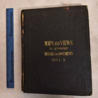
Message From the President of the United States to the Two Houses of Congress, at the Commencement of the Second Session of the Thirty-Third Congress, Part III, Illustrations Belonging to Reports Accompanying the Message
by United States General Land Office; United States Commissioner of Public Buildings; et. al
- Condition
- Used - Good (heavy shelfwear to covers, cloth spine torn, foxing spots and age toning)
- Published
- 1854
- Binding
- Hardcover
- Quantity Available
- 1
- Seller
-
Columbia, Pennsylvania, USA
- Item Price
-
$300.00
Show Details
Description:
Washington, D. C.: A.O.P. Nicholson, Printer, 1854. Hardcover. Good (heavy shelfwear to covers, cloth spine torn, foxing spots and age toning). Black cloth boards with gilt lettering, textured stamped design; unpaginated, 44 maps and plans, many of them folded. Contents: Illustrations accompanying the report of the Commissioner of the General Land Office -- Illustrations accompanying the report of… Read more about this item Item Price
$300.00