Maps from
New Arrivals

1919 - Victory Map - 1919
- Condition
- Used - Very good
- Published
- 1919
- Quantity Available
- 1
- Seller
-
Houston, Texas, USA
- Item Price
-
$675.00
Show Details
Description:
New York City: National Woman Suffrage Publishing Company, Inc, 1919. Very good. 6¾" x 4¾". Handbill. Very good: 2" stain to lower corner; lightly toned.
This is a rare handbill, illustrated with a map showing the status of women's suffrage throughout the United States.
In "Make the Map All White: The Meaning of Maps… Read more about this item Item Price
$675.00
More Photos
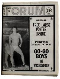
Gay Forum. Vol. 1 No. 3. December 1-15, 1971
- Condition
- Used - Near fine
- Published
- 1971
- Quantity Available
- 1
- Seller
-
Houston, Texas, USA
- Item Price
-
$675.00
Show Details
Description:
Washington DC: Guild Press, LTD, 1971. Near fine. 17½" x 11¼". Bifolia printed on regular paper stock. pp. 24. Near fine: folded horizontally at center as issued, fresh with minimal wear.
This is an issue of a short run gay periodical that signaled the downfall of a gay publishing empire. Its publisher, the Guild Press, was… Read more about this item Item Price
$675.00
![School Atlas to Cummings' Ancient & Modern Geography [Cover title]](https://d3525k1ryd2155.cloudfront.net/h/597/406/1532406597.0.m.jpg)
More Photos
School Atlas to Cummings' Ancient & Modern Geography [Cover title]
- Condition
- Used - Good
- Edition
- Ninth Edition
- Published
- 1823
- Quantity Available
- 1
- Seller
-
Houston, Texas, USA
- Item Price
-
$600.00
Show Details
Description:
Boston: Cummings, Hilliard, & Co, 1823. Ninth Edition. Good. 9½" x 6¼". Thin card wrappers. Eight double-page maps hand-colored in outline. Good: wrappers heavily soiled and separated from text block but attached to each other; three maps with chipping to edges, outside map boundaries; map of Europe with a 3" split at fold; light to moderate dust soiling… Read more about this item Item Price
$600.00
![[Three Pictorial Maps of Los Angeles]](https://d3525k1ryd2155.cloudfront.net/h/551/406/1532406551.0.m.jpg)
More Photos
[Three Pictorial Maps of Los Angeles]
by Pavia, Cathy
- Condition
- Used - Very good
- Published
- 1980
- Quantity Available
- 1
- Seller
-
Houston, Texas, USA
- Item Price
-
$2,000.00
Show Details
Description:
Los Angeles, California: Los Angeles Times, 1980. Very good. Three posters, each measuring 18" x 23". Very good: one tiny tear to edge of one map, light foxing in the margin of another; else minimal wear and light creasing to edges.
This is a set of three pictorial maps commissioned for the Los Angeles Bicentennial celebration and… Read more about this item Item Price
$2,000.00
![JCJL Map Showing Routes, Ports of Call and Services of the Java-China-Japan Line . . . [Cover title]/ Java-China Japan Lyn [Map title]](https://d3525k1ryd2155.cloudfront.net/h/491/644/1531644491.0.m.jpg)
More Photos
JCJL Map Showing Routes, Ports of Call and Services of the Java-China-Japan Line . . . [Cover title]/ Java-China Japan Lyn [Map title]
- Condition
- Used - Very good
- Published
- 1931
- Quantity Available
- 1
- Seller
-
Houston, Texas, USA
- Item Price
-
$850.00
Show Details
Description:
London, England: Stanford's Geog[raphica]l Estab[lishmen]t, 1931. Very good. Map measuring 44" x 33¼" partially glued down as issued to heavy card stock bifolium measuring 14¾" x 9" and with two pages of text and images on map's verso. Very good: minimal wear to the map which has a few insignificant spots of staining, a few small separations at… Read more about this item Item Price
$850.00

The Historical Island of Guam of the Marianas Islands
- Condition
- Used - Very good
- Published
- 1950
- Quantity Available
- 1
- Seller
-
Houston, Texas, USA
- Item Price
-
$600.00
Show Details
Description:
Guam: N.P., 1950. Very good. 34" x 31½". Map printed on silk. Very good: numerous light creases and folds; light dust-soiling.
This is an intricately pictorial map of the island of Guam, printed on silk and likely issued as a tourist souvenir, with many narrative depictions of Guamanian history and culture. Along with geographical and topographical aspects… Read more about this item Item Price
$600.00

More Photos
Map Guide" of the Lower Rio Grande Valleys of Texas & Mexico. [Front panel title]
by White, Russel M.
- Condition
- Used - Very good
- Published
- 1947
- Quantity Available
- 1
- Seller
-
Houston, Texas, USA
- Item Price
-
$1,250.00
Show Details
Description:
Texas: Russel M. White, 1947. Very good. 8 7/8" x 3 7/8", folded; opens to 17¾" x 23½"; printed both sides. Very good: light edge wear with a few tiny chips, a few minuscule separations at folds, light dust soiling, and small holes at each intersection.
This map/guide to the lower Rio Grande valley is a sensory… Read more about this item Item Price
$1,250.00
![Hotel Ancira. Monterrey, N.L. Mexico [Cover title]](https://d3525k1ryd2155.cloudfront.net/h/481/905/1445905481.0.m.jpg)
Hotel Ancira. Monterrey, N.L. Mexico [Cover title]
- Condition
- Used - Very good
- Published
- 1939
- Quantity Available
- 1
- Seller
-
Houston, Texas, USA
- Item Price
-
$350.00
Show Details
Description:
Mexico, D.F.: Propaganda y Anuncios S.A., 1939. Very good. 4 1/8" x 12", folded; opens to 23 7/8" x 18 3/8" (map area is 18 5/8" x 17 1/8"). Single sheet printed in multiple colors both sides. Very good: folded twice vertically, possibly as issued; some penciled notations in the margins by the large image of the hotel;… Read more about this item Item Price
$350.00
![Map Showing Houston & Texas Central System of Railroads. [Front Panel Title: See Texas Via the H And TC. It Takes You Through the Best Farming Country in the State.]](https://d3525k1ryd2155.cloudfront.net/h/719/177/1386177719.0.m.jpg)
More Photos
Map Showing Houston & Texas Central System of Railroads. [Front Panel Title: See Texas Via the H And TC. It Takes You Through the Best Farming Country in the State.]
- Condition
- Used - Very good
- Published
- 1897
- Quantity Available
- 1
- Seller
-
Houston, Texas, USA
- Item Price
-
$1,500.00
Show Details
Description:
Chicago: Poole Bros. Map Engravers, 1897. Very good. 8¾" x 4" folded; opens to 17½" x 34¾"; Map of the United States: 16½" x 30½"; County Map of Texas: 11¼" x 11¼". Very good: moderate staining and a few small nibble holes to outer panels costing a couple of characters in panels, and a tiny portion of the… Read more about this item Item Price
$1,500.00

More Photos
Denver & Rio Grande Official Guide to Cities, Villages and Resorts on the Line of the Denver & Rio Grande R.R. . .
- Condition
- Used - Good
- Published
- 1888
- Quantity Available
- 1
- Seller
-
Houston, Texas, USA
- Item Price
-
$2,000.00
Show Details
Description:
Denver, Col: The Western Publishing Company, 1888. Good. 9½" x 6¼". pp. 286, [4] + folding map measuring 17¾" x 15". Good: front hinge and first two leaves partially detached but holding, three inch tear to top of backstrip; tiny bit of staining to margins of versos of first 17 leaves. Map very good minus with a 2"… Read more about this item Item Price
$2,000.00

Rand, McNally & Co.'s Indexed County And Railroad Pocket Map And Shippers' Guide Of Texas . .
- Condition
- Used - Fine
- Published
- 1904
- Quantity Available
- 1
- Seller
-
Houston, Texas, USA
- Item Price
-
$900.00
Show Details
Description:
Chicago And New York: Rand, McNally & Co, 1904. Fine. 6 ½" x 4", map measures 27 7/8" x 40". Printed card wrappers. pp. 58 + 6 pages of ads+ folding map. Very good book with moderate wear and a faint dampstain to front wrapper; map fine: bright and fresh with a tiny separation at one margin and… Read more about this item Item Price
$900.00
Barker, Ralph. Map of the Waterfront of San Francisco From Sonoma St. to Van Ness Ave
- Condition
- Used - Very good
- Published
- 1908
- Quantity Available
- 1
- Seller
-
Houston, Texas, USA
- Item Price
-
$750.00
Show Details
Description:
N.p.: N.p., 1908. Very good. 15 3/8" x 41¾". Printed on a coated, waxlike paper. Very good : a couple of tiny separations at intersections, small closed tear at another, 2" vertical separation at far upper left, a couple of small edge chips, some scattered pinpoints of soiling.
A scarce map of San Francisco's waterfront, its… Read more about this item Item Price
$750.00