Maps from Main Street Fine Books & Manuscripts, ABAA
New Arrivals

Decorative Printed Maps of the 15th to 18th Centuries
by SKELTON, R.A.
- Condition
- Used
- Published
- 1952
- Binding
- Hardcover
- Quantity Available
- 1
- Seller
-
Galena, Illinois, USA
- Item Price
-
$45.00
Show Details
Description:
London / New York: Staples Press, 1952. Hardcover. 4to. Burgundy cloth with gilt spine lettering, pictorial dust jacket. 80pp, (168pp). Numerous full-page illustrations (1 color). Very good/very good. Binding nice but for tiny mended scuff near foot; internally tight and near fine; jacket a bit edgeworn, with several chips and slightly sunned spine. Tight and nice first of this… Read more about this item Item Price
$45.00

Illustrated Historical Atlas of the State of Iowa
by ANDREAS, A.T.
- Condition
- Used
- Published
- n.y.
- Binding
- Hardcover
- Quantity Available
- 1
- Seller
-
Galena, Illinois, USA
- Item Price
-
$150.00
Show Details
Description:
Iowa City: State Historical Society of Iowa, n.y.. Hardcover. 4to. Full brown leatherette with gilt lettering and medallion. xvi, 580pp. Extensive maps, illustrations, map endpapers. Fine. Superb and tight if undated (1970) facsimile reprint of this large classic 1875 reference, originally released in a bewildering variety that differed by congressional district, offering slightly differing lithographs. This fine facsimile is… Read more about this item Item Price
$150.00

Atlas of Medieval Europe
by MacKAY, Angus, and DITCHBURN, David (editors)
- Condition
- Used
- Published
- 1997
- Binding
- Hardcover
- ISBN
- 9780415019231
- Quantity Available
- 1
- Seller
-
Galena, Illinois, USA
- Item Price
-
$55.00
Show Details
Description:
London: Routledge, 1997. Hardcover. Small 4to. Black cloth with silver spine lettering, pictorial dust jacket. ix, 271pp. Extensive maps, decorative endpapers. Fine/fine.Circular blind-embossed ownership imprint on half-title page. Pristine first edition of this important and fascinating reference "filled with over 140 maps and commentaries" -- to cite front flap copy -- "detailing the whole of the medieval period from… Read more about this item Item Price
$55.00
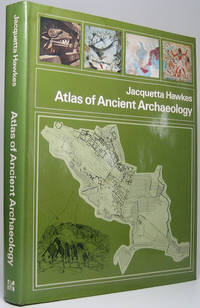
Atlas of Ancient Archaeology
by HAWKES, Jacquetta (editor)
- Condition
- Used
- Published
- 1975
- Binding
- Hardcover
- Quantity Available
- 1
- Seller
-
Galena, Illinois, USA
- Item Price
-
$50.00
Show Details
Description:
New York: McGraw-Hill Book Company, 1975. Hardcover. 4to. Green cloth with gilt spine lettering, pictorial dust jacket. 272pp. Extensive maps and floor plans, line drawings. Fine/near fine. Tight, handsome second U.S. printing of this exceptionally useful reference, first published 1974. Item Price
$50.00
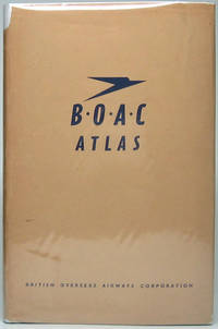
BOAC Atlas
by (BRITISH OVERSEAS AIRWAYS CORPORATION)
- Condition
- Used
- Published
- n.y.
- Binding
- Hardcover
- Quantity Available
- 1
- Seller
-
Galena, Illinois, USA
- Item Price
-
$95.00
Show Details
Description:
London: British Overseas Airways Corporation, n.y.. Hardcover. Small 8vo. Blue cloth with gilt lettering, dust jacket. (Ca. 100pp), 24pp. Extensive color maps. Near fine/very good. Mild jacket wear, mainly a slightly age-toned spine with chips at head and tail. Probable first and sole edition. Handsome and tight world atlas published by the British state-owned airline, which in 1974 became… Read more about this item Item Price
$95.00

More Photos
Atlas of American Military History
by BRADFORD, James C. (editor)
- Condition
- Used
- Published
- 2003
- Binding
- Hardcover
- Quantity Available
- 1
- Seller
-
Galena, Illinois, USA
- Item Price
-
$55.00
Show Details
Description:
New York: Oxford University Press, 2003. Hardcover. 4to. Full brown leatherette with gilt lettering, rules and pictorial stamping 248pp. All edges gilt. Extensive color maps, illustrations, brown watered silk endpapers, sewn-in gold satin page marker. Near fine. Wonderfully tight and handsome first edition covering the early 16th century to the late 20th century. Item Price
$55.00
Atlas of the First World War
by GILBERT, Martin
- Condition
- Used
- Published
- 1994
- Binding
- Hardcover
- ISBN
- 9780195210750
- Quantity Available
- 1
- Seller
-
Galena, Illinois, USA
- Item Price
-
$45.00
Show Details
Description:
New York: Oxford University Press, 1994. Hardcover. Small 4to. Blue cloth with gilt spine lettering, pictorial dust jacket. ix, 164pp, xvii-xxxii. Extensive maps. Fine/near fine. Circular ownership blind-emboss on front and rear flyleaves. Handsome first printing of the revised second edition of this history of WWI in maps, far superior to the 1974 first edition. Item Price
$45.00

County Map of Minnesota
by (MINNESOTA -- Map)
- Condition
- Used
- Published
- 1880
- Quantity Available
- 1
- Seller
-
Galena, Illinois, USA
- Item Price
-
$60.00
Show Details
Description:
New York: S. Augustus Mitchell, Jr., 1880. Folio (12¼" X 15¼", image area 11½" X 14"). Hand colored. Very good. Mild age toning. Attractive hand colored map of the 32nd state, from the 1880 edition of "Mitchell's New General Atlas, Containing Maps of the Various Countries of the World, Plans of Cities, Etc." The 1862 printing of this map… Read more about this item Item Price
$60.00
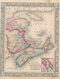
County Map of Nova Scotia New Brunswick Cape Breton Id. and Pr. Edward's Id
by (NOVA SCOTIA -- NEW BRUNSWICK -- CAPE BRETON -- PRINCE EDWARD'S ISLAND -- Map)
- Condition
- Used
- Published
- 1860
- Quantity Available
- 1
- Seller
-
Galena, Illinois, USA
- Item Price
-
$80.00
Show Details
Description:
New York: S. Augustus Mitchell, Jr., 1860. Folio (12¼" X 15¼", image area 10½" X 13½"). Hand colored. Very good. Slightly age toned, with mild soiling (mainly about edges). A nice example of this well-colored multi-province Canadian map, from the 1864 edition of "Mitchell's New General Atlas, Containing Maps of the Various Countries of the World, Plans of Cities,… Read more about this item Item Price
$80.00

Map of North America Showing Its Political Divisions, and Recent Discoveries in the Polar Regions
by (NORTH AMERICA -- Map)
- Condition
- Used
- Published
- 1860
- Quantity Available
- 1
- Seller
-
Galena, Illinois, USA
- Item Price
-
$80.00
Show Details
Description:
New York: S. Augustus Mitchell, Jr., 1860. Folio (12¼" X 15", image area 10½" X 13½"). Hand colored. Very good. Mildly age toned, with minor soiling mainly about the edges and single small discreet stain. Quite nice example of this softly-colored continent map, from the 1864 edition of "Mitchell's New General Atlas, Containing Maps of the Various Countries of… Read more about this item Item Price
$80.00
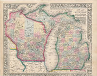
County Map of Michigan and Wisconsin
by (MICHIGAN -- WISCONSIN -- Map)
- Condition
- Used
- Published
- 1863
- Quantity Available
- 1
- Seller
-
Galena, Illinois, USA
- Item Price
-
$90.00
Show Details
Description:
New York: S. Augustus Mitchell, Jr., 1863. Folio (15¼" X 12¼", image area 13 3/4" X 11 3/4"). Hand colored. Very good. Light age toning and bit of soiling. Nice, bright map of these side-by-side Midwest states, from the 1864 edition of "Mitchell's New General Atlas, Containing Maps of the Various Countries of the World, Plans of Cities, Etc."… Read more about this item Item Price
$90.00
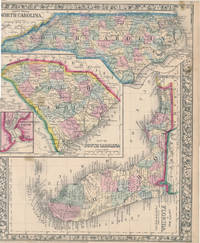
County Map of Florida / County Map of North Carolina / Map of South Carolina
by (FLORIDA -- NORTH CAROLINA -- SOUTH CAROLINA -- Map)
- Condition
- Used
- Published
- 1860
- Quantity Available
- 1
- Seller
-
Galena, Illinois, USA
- Item Price
-
$100.00
Show Details
Description:
New York: S. Augustus Mitchell, Jr., 1860. Folio (12¼" X 15¼", image area 11½" X 14"). Hand colored. Very good. Lightly age toned, with bit of faint soiling; couple of small, discreet stains. A well colored map of this southern trio, from the 1864 edition of "Mitchell's New General Atlas, Containing Maps of the Various Countries of the World,… Read more about this item Item Price
$100.00

The World in Hemispheres. With Other Projections &c. &c
by (WORLD MAP)
- Condition
- Used
- Published
- 1860
- Quantity Available
- 1
- Seller
-
Galena, Illinois, USA
- Item Price
-
$100.00
Show Details
Description:
New York: S. Augustus Mitchell, Jr., 1860. Folio (15¼" X 12¼", image area 13" X 11"). Hand colored. Very good. Some age toning and faint soiling. Delicately colored example of this world map, from the 1864 edition of "Mitchell's New General Atlas, Containing Maps of the Various Countries of the World, Plans of Cities, Etc." Centered below the "Western… Read more about this item Item Price
$100.00

More Photos
Map of Mexico, Central America, and the West Indies
by (MEXICO -- CENTRAL AMERICA -- WEST INDIES -- Map)
- Condition
- Used
- Published
- 1860
- Quantity Available
- 1
- Seller
-
Galena, Illinois, USA
- Item Price
-
$125.00
Show Details
Description:
New York: S. Augustus Mitchell, Jr., 1860. Folio (23½" X 15¼", image area 21¼" X 13¼"). Hand colored. Very good. Some age toning and minor soiling (mainly about edges), with single small inoffensive stain and single vertical fold (as issued). Wonderfully colored centerfold map of this large region, from the 1864 edition of "Mitchell's New General Atlas, Containing Maps… Read more about this item Item Price
$125.00

More Photos
County Map of the States of New York, New Hampshire, Vermont, Massachusetts, Rhode Id. and Connecticut
by (NEW YORK -- NEW HAMPSHIRE -- VERMONT -- MASSACHUSETTS -- RHODE ISLAND -- CONNECTICUT -- Map)
- Condition
- Used
- Published
- 1860
- Quantity Available
- 1
- Seller
-
Galena, Illinois, USA
- Item Price
-
$90.00
Show Details
Description:
New York: S. Augustus Mitchell, Jr., 1860. Folio (23½" X 15¼", image area 21¼" X 13½"). Hand colored. Very good. Slightly age toned and mildly soiled about the edges, with single vertical fold (as issued). Nice centerfold map of New England, from the 1864 edition of "Mitchell's New General Atlas, Containing Maps of the Various Countries of the World,… Read more about this item Item Price
$90.00

County Map of Ohio and Indiana
by (OHIO -- INDIANA -- Map)
- Condition
- Used
- Published
- 1864
- Quantity Available
- 1
- Seller
-
Galena, Illinois, USA
- Item Price
-
$65.00
Show Details
Description:
New York: S. Augustus Mitchell, Jr., 1864. Folio (15¼" X 12¼", image area 14" X 11½"). Hand colored. Very good. Mild age toning and bit of soiling. Really well colored map of these Midwest side-by-siders, from the 1864 edition of "Mitchell's New General Atlas, Containing Maps of the Various Countries of the World, Plans of Cities, Etc." A lushly--colored… Read more about this item Item Price
$65.00
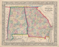
County Map of Georgia and Alabama
by (GEORGIA -- ALABAMA -- Map)
- Condition
- Used
- Published
- 1860
- Quantity Available
- 1
- Seller
-
Galena, Illinois, USA
- Item Price
-
$85.00
Show Details
Description:
New York: S. Augustus Mitchell, Jr., 1860. Folio (15¼" X 12¼", image area 13¼" X 10 3/4"). Hand colored. Very good. Lightly age toned, with faint soiling. Attractively colored map of these two side-by-side southern states, from the 1864 edition of "Mitchell's New General Atlas, Containing Maps of the Various Countries of the World, Plans of Cities, Etc." Sharp… Read more about this item Item Price
$85.00

Map of South America, Showing Its Political Divisions
by (SOUTH AMERICA -- Map)
- Condition
- Used
- Published
- 1860
- Quantity Available
- 1
- Seller
-
Galena, Illinois, USA
- Item Price
-
$85.00
Show Details
Description:
New York: S. Augustus Mitchell, Jr., 1860. Folio (12¼" X 15¼", image area 10½" X 13½"). Hand colored. Near fine. Light age toning and faint soiling. Nice, bold map of this continent, from the 1864 edition of "Mitchell's New General Atlas, Containing Maps of the Various Countries of the World, Plans of Cities, Etc." Inset at lower right contains… Read more about this item Item Price
$85.00
More Photos
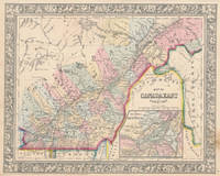
Map of Canada East in Counties / Map of Canada West in Counties
by (EASTERN CANADA -- WESTERN CANADA -- Map)
- Condition
- Used
- Published
- 1860
- Quantity Available
- 1
- Seller
-
Galena, Illinois, USA
- Item Price
-
$150.00
Show Details
Description:
New York: S. Augustus Mitchell, Jr., 1860. Each folio (15¼" X 12¼", image areas 13¼" X 10½"). Hand colored. Very good. Slightly age toned, with minor soiling. Handsome pair of maps of Canada's eastern counties and what was then her western counties, from the 1864 edition of "Mitchell's New General Atlas, Containing Maps of the Various Countries of the… Read more about this item Item Price
$150.00
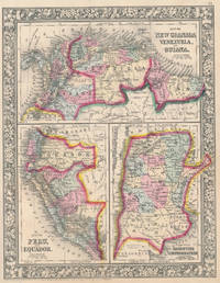
Map of New Granada, Venezuela, and Guiana / Map of Peru, and Equador / Map of the Argentine Confederation
by (NEW GRANADA -- VENEZUELA -- GUIANA -- PERU -- EQUADOR -- ARGENTINA -- Map)
- Condition
- Used
- Published
- 1860
- Quantity Available
- 1
- Seller
-
Galena, Illinois, USA
- Item Price
-
$55.00
Show Details
Description:
New York: S. Augustus Mitchell, Jr., 1860. Folio (12¼" X 15¼", image area 10½" X 13½"). Hand colored. Very good. Mild age toning and bit of faint soiling. Quite nice map of these half dozen South American countries, from the 1864 edition of "Mitchell's New General Atlas, Containing Maps of the Various Countries of the World, Plans of Cities,… Read more about this item Item Price
$55.00