Map/Atlas from OLD WORKING BOOKS & Bindery (Est. 1994)
New Arrivals

More Photos
BALTIC SEA IN ANCIENT MAPS, The.
by Spekke, Arnolds.
- Condition
- Used
- Quantity Available
- 1
- Seller
-
West Brookfield, Massachusetts, USA
- Item Price
-
$80.00
Show Details
Description:
Stockholm: M. Goppers, 1961. Translated by A. J. Grinbergs from the Latvian. Illustrated by frontis, 14 plates (10 of which are folding), 7 text maps and fragments. First edition. 1/1000 copies. tan cloth, gilt print, uncut. narrow 4to . pp. ix, [1], 75, [1], [1] colophon. Near Fine/Very Good/No price in mylar. Paper uncoated jacket has been bleached resulting in… Read more about this item Item Price
$80.00

More Photos
Road Map of FLORIDA No. 13, 1930
by Gulf.
- Condition
- Used
- Quantity Available
- 1
- Seller
-
West Brookfield, Massachusetts, USA
- Item Price
-
$25.00
Show Details
Description:
Boston et al: Gulf Refining Company, 1930. Illustrated by Three color map and ads. Folded map. 18 x 12-inches foling to 9 x 4-inches. pp. 2. Very Good. Old wrinkles, new tear repairs, still brilliant. Early Seven Sisters oil company with the familiar orange, blue and white logo making their brand a new economy business headquartered in Wellesley, Massachusetts..… Read more about this item Item Price
$25.00

More Photos
Framed Map of Boston, County of Suffolk and the Adjacent Towns 1830
by Bowen, Abel 1790-1850.
- Condition
- Used
- Quantity Available
- 1
- Seller
-
West Brookfield, Massachusetts, USA
- Item Price
-
$400.00
Show Details
Description:
Boston: Carter and Hendee, 1830. Illustrated by colored map (mostly blue). First edition. Map is from A Geography of Boston, County of Suffolk and the Adjacent Towns With Historical Notes with Maps and Plates for the Younger Class of Readers by C. H. Snow. Dark brown hardwood frame with pressed and lacquered map with only one faint fold line. map… Read more about this item Item Price
$400.00
More Photos
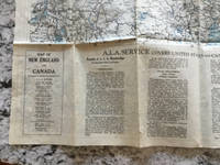
ALA MAP OF NEW ENGLAND AND CANADA.
by Thibodeau, W. A.
- Condition
- Used
- Quantity Available
- 1
- Seller
-
West Brookfield, Massachusetts, USA
- Item Price
-
$25.00
Show Details
Description:
Boston: Automobile Legal Assn, [ca. 1920's]. Illustrated by some color. unspecified edition. folded onion skin map. 32.75 x 26.25 inches folding to 6.75 x 4.25-inches. pp. 2. Near Fine. Two tiny repaired edge tears. Recto is New England and part of New York; Verso is Quebec, Northern Maine and Maritime Provinces.. Item Price
$25.00

More Photos
NEW ENGLAND TOUR MAP: Main Traveled Routes with detail maps of principle cities.
by ALA.
- Condition
- Used
- Quantity Available
- 1
- Seller
-
West Brookfield, Massachusetts, USA
- Item Price
-
$35.00
Show Details
Description:
Boston: Walker Lith. & Pub. Co, [1912 May & August printings]. Illustrated by Walker ad and maps. unspecified edition. folded thick paper issue map. 24 x 19.25 inches folding to 8.5 x 4-inches. pp. 2. About Very Good. Repaired fold tears with tiny bit of text missing from NY border under Saratoga. A bit misfolded. According to Pierce and Slautterback,… Read more about this item Item Price
$35.00

More Photos
DIETFURT (E) Sheet No. 47E. Bavaria 1:50,000.
by MAP.
- Condition
- Used
- Quantity Available
- 1
- Seller
-
West Brookfield, Massachusetts, USA
- Item Price
-
$30.00
Show Details
Description:
N. P: Published by War Office 1944, 4/APR 45/661E/GAG 7691. Stated First edition. copied from Bavaria 1:50,000 Sheet 47E 1935. Broadside colored map. 22.375 by 20-inches folded to 11.25 x 5.25-inches. Good+. Several archival tear repairs, color bright. English legend which includes hopfields.. Item Price
$30.00

More Photos
Leinen Folding Karte von Nordšstliches, Frankreich und Belgien (Linen Folding Map of Northeastern France and Belgium) .
- Condition
- Used
- Quantity Available
- 1
- Seller
-
West Brookfield, Massachusetts, USA
- Item Price
-
$25.00
Show Details
Description:
New York: C. S Hammond Publishers, n.d. (ca.1917). Illustrated by Geographiche Anstall von Velhagen und Klafing, Leipzig. Linen backed color folding map. 27.75x27 folding to 9.25x5.5 inches (70.5x68.5 folding to 23.5x14 cm). Very Good. Handwritten paper label of C. F. Hinck. Repaired with archival linen tape and filmplast, shaved tears at cuts but still a functional map.. Item Price
$25.00

Map of Roman Britain scale 10 miles to one inch.
by Ministry of agriculture and Fisheries.
- Condition
- Used
- Quantity Available
- 1
- Seller
-
West Brookfield, Massachusetts, USA
- Item Price
-
$30.00
Show Details
Description:
Southampton: Ordnance Survey Office, 1931. Illustrated by color. Second edition. Linen backed map in printed paper wrappers. pp. 16, map. Very Good. Archival repairs to wrappers, map fine.. Item Price
$30.00

More Photos
WEATHER MAP.
by Kao, Channing Rwen, Ph.D., Ed.
- Condition
- Used
- Quantity Available
- 1
- Seller
-
West Brookfield, Massachusetts, USA
- Item Price
-
$15.00
Show Details
Description:
Baltimore: Ottenheimer Publishers, Inc, 1962. Illustrated by color by editor/author. First edition. No. 5904. Folded map. 25.3x16cm folded; 63x96xcm open. Near Fine. Traces of wear to one fold. Plethora of information: Cold front, Warm front, Occluded front, Tornado, Hurricane or Typhoon, General circulation of the air, Solar radiation, North American air masses & their usual paths, Some weather instruments, Selected… Read more about this item Item Price
$15.00

More Photos
WORLD MAP in Equal Area Presentation: PETERS PROJECTION.
by UNDP (United Nations Development Program), produced with support of.
- Condition
- Used
- Quantity Available
- 1
- Seller
-
West Brookfield, Massachusetts, USA
- Item Price
-
$150.00
Show Details
Description:
Oxford: Oxford Cartographers, Ltd. (Friendship Press, New York), 1983. Stated First English Version edition. Copyright by Akademische Verlagsanstalt, FL-9490 Vaduz, Aeulestr. 56. One color map folded to 30x22cm. 90x132cm. Fine. Unopened condition. Seven illustrated maps with text explaining distortions under (72 x 113cm) map. Folded sides are pictured. Scarce and true first English Version of the controversial map (also featured… Read more about this item Item Price
$150.00

Civil War Battlefields 1861-1865, Civil War Chronological History.
by Map.
- Condition
- Used
- Quantity Available
- 1
- Seller
-
West Brookfield, Massachusetts, USA
- Item Price
-
$20.00
Show Details
Description:
U.S.A: Historical Document Co, 1961. Illustrated by map and flags. Parchment broadside, folded. 40x35cm. Near Fine. Light edge stain to top corner.. Item Price
$20.00

WORLD MAP, The.
by Nitchi.
- Condition
- Used
- ISBN
- 9784527010230
- Quantity Available
- 1
- Seller
-
West Brookfield, Massachusetts, USA
- Item Price
-
$15.00
Show Details
Description:
Tokyo, Japan: Nitchi Map Publishing Co., Ltd, 1992. Illustrated by color. Later edition. c.1988. C0326 P1030E. Folded map in gloss pictorial folder. 28x40.5-inches. Fine. Unfolded for dimensions for the first time. English and Japanese. ISBN: 4527010239.. Item Price
$15.00

ELEMENTS OF MAP PROJECTION with Applications to map and chart construction: Special Publication No. 68
by Deetz, Charles H. and Oscar S. Adams.
- Condition
- Used
- Quantity Available
- 1
- Seller
-
West Brookfield, Massachusetts, USA
- Item Price
-
$30.00
Show Details
Description:
Washington, DC: GPO, 1921. Illustrated by 74 b/w map figures and 8 pull-out plates. First edition. Serial No. 146. Original wraps. Imperial 8vo. pp. 163, [1], 16 (plates). Very Good-. Top cover very chipped with several pen numbers, corner bump throughout, toning. Maps near fine.. Item Price
$30.00
Rand McNally ILLUSTRATED ATLAS, Maps, Pictures, Descriptions Covering the World.
by [Rand McNally].
- Condition
- Used
- Quantity Available
- 1
- Seller
-
West Brookfield, Massachusetts, USA
- Item Price
-
$20.00
Show Details
Description:
Chicago: Rand McNally, (1937). Illustrated by color & b/w maps, b/w photos. First thus edition. Green pebble cloth, reinforced binding, gilt print topboard title. Folio. pp. 64. VG+. Only flaws are area of darker soil on topboard, publisher's wrinkle on rear paste down. Internally fine.. Item Price
$20.00
NEW WORLD HORIZONS: Geography for the Air Age, 10th Edition.
by Lawrence, Chester H., editor.
- Condition
- Used
- Quantity Available
- 1
- Seller
-
West Brookfield, Massachusetts, USA
- Item Price
-
$15.00
Show Details
Description:
New York: Silver Burdett Co. (with arrangement with Duell, Sloan & Pearce), (1942). Illustrated by Ray Ramsey color maps, b&w photographs. Later edition. Brown cloth printed and illustrated white. Medium 4to. pp. 96. References, Index. VG/In like jacket/Unclipped price in mylar. Light edgewear, soil and creasing to jacket. Foreword by Walter W. Ristow Ph.D.. Item Price
$15.00
New Map of England & Wales showing main roads with Ministry of Transport Numbers.
by Geographia.
- Condition
- Used
- Quantity Available
- 1
- Seller
-
West Brookfield, Massachusetts, USA
- Item Price
-
$15.00
Show Details
Description:
London: "Geographia" Ltd, n.d. Paper fold-out map in printed folder with yapped edges . 100 x 75cm. VG/Unclipped price in mylar. One 9.5cm tear to top at 4 degree longitude mark.. Item Price
$15.00
Map Interpretation with Military Applications.
by Putnam, William C.
- Condition
- Used
- Quantity Available
- 1
- Seller
-
West Brookfield, Massachusetts, USA
- Item Price
-
$15.00
Show Details
Description:
New York: McGraw-Hill , 1943. Illustrated by b/w photos, maps and line drawings. Stated First edition. Burgundy cloth, Yellow print top. 4to. pp. viii, 67. VG/No jacket. Designed for Army and Navy ROTC 3-hour course on contour maps, aerial photographs, and geologic interpretation . Used in conjunction with FM 21-26 and FM 21-30. (Military History).. Item Price
$15.00
MAP READING (Field Manual FM 21-26)
by DOA.
- Condition
- Used
- Quantity Available
- 1
- Seller
-
West Brookfield, Massachusetts, USA
- Item Price
-
$15.00
Show Details
Description:
Washington, DC: HQ Department of the Army, October 1960. Illustrated by Maps: Pull-out pp. 206, [2]. First edition. (Supersedes FM 21-26, 28 Mar 1956 including C1 25 Jun 1956). Stiff-wraps, tan cover printed black. 8vo. pp. 222. Appendices, Index. VG/No jacket, as issued/Near fine.. Item Price
$15.00
New York University, Map No. 2: University Heights Campus, Medical College, Washington Square Center, Wall Street Center.
by Ohman Map Co.
- Condition
- Used
- Quantity Available
- 1
- Seller
-
West Brookfield, Massachusetts, USA
- Item Price
-
$10.00
Show Details
Description:
New York: Director of Public Occasions, 1922. 5 3/8" by 17" folded b/w street map with red and blue lines recto, 5 b/w photos and text verso. pp. [2]. VG+. Slight age darkening.. Item Price
$10.00

More Photos
CENTRAL MASSACHUSETTS, Automobile Map No.9
by Walker, (George H.).
- Condition
- Used
- Quantity Available
- 1
- Seller
-
West Brookfield, Massachusetts, USA
- Item Price
-
$50.00
Show Details
Description:
Boston: Walker Lith. & Pub ca.1915. Linen backed sectional color folding map which stores to 9.25 x 5-inches, printed cards showing front and back replace two linen sections. 34.5 x 27.5-inches opened. Map very good, some straightened folds, with edge soil when folded, linen still white. The map sections are 7 wide by 3 long equalling 21 sections… Read more about this item Item Price
$50.00