Atlas from Open Door Books
New Arrivals

'Camp's Higher Geography, Prepared To Accompany Mitchell's Series Of Outline Maps, And Designed For Grammar And High Schools, And For Higher Classes Of District Schools.
by David N. Camp
- Condition
- Used - Good to Fair
- Edition
- 1st Edition
- Published
- 1862
- Binding
- Hardcover
- Quantity Available
- 1
- Seller
-
Bath, Maine, USA
- Item Price
-
$294.00
Show Details
Description:
St. Louis, Mo.: Western Publishing And School Furnishing Co.,, 1862 Green Past-On Paper Fragile With Chips, Leather Spine Perished, Edges Of Boards Rubbed, Holding, Text Block Tight. Marking To Fep, Some Soiling. Light Owner's Inscription M. L. Harris. Hand Colored Full Page Maps, Engravings. Hints To Teachers Vi. 200 Pgs Some Light Foxing. Pgs 127-28 Torn /Repaired. Rear Past Down… Read more about this item Item Price
$294.00
Atlas Of Piscataquis County Maine 1882
by Compiled Drawn And Published From Official Plans And Actual Surveys.
- Condition
- Used - Good
- Edition
- 1st Edition
- Published
- 1882
- Binding
- Hardcover
- Quantity Available
- 1
- Seller
-
Bath, Maine, USA
- Item Price
-
$490.00
Show Details
Description:
Houlton And Dover Me.: George N. Colby & Co, 1882 Embossed Covers With Original Leather Spine, Tight, Clean. Some Edgewear. Five Early Pages Have Old Tape Repairs, Tears, Now Yellowed. A Few Red X's On Some Maps Marking Locations I Guess. All Colored Maps, Pages Present. Page 35 Has List Of Piscataquis County 1St Infantry Regiment, Reserve Militia. Lists Of… Read more about this item Item Price
$490.00
School History Of The United States, Containing Maps, A Chronological Chart And An Outline Of Topics For A More Exrensive Course Of Study.
by Hall, S. R. Baker, A. R.
- Condition
- Used - Very Good
- Edition
- Early American Edition.
- Published
- 1845
- Binding
- Hardcover
- Quantity Available
- 1
- Seller
-
Bath, Maine, USA
- Item Price
-
$73.50
Show Details
Description:
Boston: Benjamine B. Mussey, 1845 Period Leather With Black Title Plate Gilt Banded Spine. Light Rubbed, Boards Tight. Missing Fep And Chart. 8 Maps Very Good Detail. Pencil Notes And Marks. 368 Pgs.Comprehensive History.. 12mo - over 6¾ - 7¾" tall. Owner's Name. Early American Edition.. Full-Leather. Very Good. Item Price
$73.50
System Of Modern Geography, On The Principles Of Comparison And Classification. Illustrated With Maps And Engravings And Accompanied By An Atlas, .
by Woodbridge, William Channing ; Willard, Emma.
- Condition
- Used - Near Fine
- Edition
- 1st Edition
- Published
- 1844
- Binding
- Hardcover
- Quantity Available
- 1
- Seller
-
Bath, Maine, USA
- Item Price
-
$98.00
Show Details
Description:
Hartford: Belknap And Hamersley, 1844 Black Leather Gilt Banded Spine, Red Card Printed Covers, Tight. New Edition Revised And Enlarged. Xvii Preface, By Mrs Wilard.Analysis Of The Contents;Exercises On The Maps. 474 Pgs. 9 Pgs Of Engravings. Bound With : Ancient Geography As Connected With Chronology, And Preparatory To Ancient History Accompanied By An Atlas By Emma Willard. 96 Pgs,… Read more about this item Item Price
$98.00
M'culloch's Universal Gazetter. A Dictionary, Geographical, Statistical And Historical Of The Various Countries, Places And Principle Objects In The World Illustrated With Seven Large Maps In Two Volumes Vol. I Only
by M'culloch, J. R. Esq.
- Condition
- Used - Very Good
- Edition
- 1st Edition
- Published
- 1847
- Binding
- Hardcover
- Quantity Available
- 1
- Seller
-
Bath, Maine, USA
- Item Price
-
$147.00
Show Details
Description:
New York: Harper& Brothers, 1847 Brown Period Calf, With Black Title Plates Banded Spine, Marbled Fore Edges. All 4 Foldout Maps Present. Maps Engraved By Charles Copley, 25 X 22 Inches, Are Suitable For Framing. Three Have Not Been Folded Properly, Thus Are Crumpled With Short Tears At Margins. Binding Tight. Marbled End Pages. 1148 Pgs.. 4to - over 9¾… Read more about this item Item Price
$147.00
More Photos
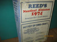
Reed's Nautical Almanac 1974 American East - Coast Edition
by Atts, Oswald M. Editiorial Consultant
- Condition
- Used - Very Good
- Edition
- First Edition.
- Published
- 1974
- Binding
- Hardcover
- Quantity Available
- 1
- Seller
-
Bath, Maine, USA
- Item Price
-
$37.24
Show Details
Description:
New York: Thomas Reed Publications Limited, 1974 Slight soiling covers, o/w tight clean 838 pgs advertisments. Scarce Size: 12mo - over 6¾" - 7¾" tall. First Edition.. Stiff Card w/color Paste-on. Very Good. Item Price
$37.24
More Photos
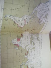
The American Universal Geography:Or a View of the Present State of All the Empires, Kingdoms, States and Republics in the Known World, and of the United States in Particular. In Two Parts to Which is Added,. System of Modern Geography. General Atlas of
by Morse, Jedidiah D. D.
- Condition
- Used - Good
- Edition
- Fifth Edition Corrected and Improved.
- Published
- 1805
- Binding
- Hardcover
- Quantity Available
- 1
- Seller
-
Bath, Maine, USA
- Item Price
-
$318.50
Show Details
Description:
Boston: Printed By J. T. Buckingham, for Thomas & Andrews., 1805 Brown calf, normal wear, boards holding good, spine split top 1 1/2 inch. Moses Emerson bookplate. First foldout map from Arrowsmith Map of the World, Published by Thomas & Andrews, Vol. 1. 6, [3], 18-864 p. 3 folded leaves of plates. Addenda v.1 [7] includes index. Foxing, dampstain top… Read more about this item Item Price
$318.50
Luzern Vierwaldstattersec Und
- Condition
- Used - Very Good
- Edition
- Deluxe Edition.
- Published
- 1893
- Binding
- Hardcover
- Quantity Available
- 1
- Seller
-
Bath, Maine, USA
- Item Price
-
$98.00
Show Details
Description:
Luzern: J. Glig. Buehblnderel Luzern, 1893 Brown/gilt leather. With many colored fold out maps, illustrated. Rare Size: 16mo - over 5¾" - 6¾" tall. Deluxe Edition.. Full-Leather. Very Good. Item Price
$98.00
More Photos
Sailing Directions for the Coasts of France, Belgium, and Holland, Between Cape Gris Nez and the Texel, Compiled from Recent Surveys
- Condition
- Used - Very Good
- Edition
- First Edition.
- Published
- 1871
- Binding
- Paperback
- Quantity Available
- 1
- Seller
-
Bath, Maine, USA
- Item Price
-
$142.10
Show Details
Description:
London: James Imray and Son, 1871 Blue/black covers, Charts ad rear cover, clean tight. ** That part of the North Sea which is included between Rivers Thames and Schelde 92 pgs. Illustrations, data, Appendix, Glossary. Scarce. Size: 8vo - over 7¾" - 9¾" tall. First Edition.. Original Stiff Paper. Very Good. Item Price
$142.10
Short Notes and Sailing Directions with Remarks on Making Passages; to Accompany a Chart of the South Atlantic
by Rosser, W, H,
- Condition
- Used - Good
- Edition
- First Edition.
- Published
- 1866
- Binding
- Paperback
- Quantity Available
- 1
- Seller
-
Bath, Maine, USA
- Item Price
-
$142.10
Show Details
Description:
London: James Imray and Son, 1866 Blue/black card,w/ some stains, wear, esp at spine. 32 pgs. Ad rear cover. Tables, measurments, data, includes: Doubtful Islands, Rocks, and Shoals list with coordinates of supposed locations, but recomends removal from charts. Deep sea Soundings ect. Rare OCLC finds 9 copies. Size: 8vo - over 7¾" - 9¾" tall. First Edition.. Original Wraps.… Read more about this item Item Price
$142.10
Bennett's Handbook for Travellers in Norway with Through Routes to Sweden and Denmark with Route Map and Four Plans
- Condition
- Used - Very Good
- Edition
- Thirty First Edition Revised
- Published
- 1925
- Binding
- Hardcover
- Quantity Available
- 1
- Seller
-
Bath, Maine, USA
- Item Price
-
$31.36
Show Details
Description:
Oslo (Norway): Bennett's Travel Bureau, 1925 Red/gilt cloth x index 293 pgs. Hotel Advertising Guide Alphabetically Arranged According to Places xiv liv. Scarce copy of clean tight guide. Size: 16mo - over 5¾" - 6¾" tall. Thirty First Edition Revised. Cloth. Very Good. Item Price
$31.36
Geography Made Easy Being an Abridgement of the American Universal Geography to Which are Prefixed Elements of Geography For the Use of Schools and Academies in the United States of America Ect.
by Morse, Jedidiah D. D.
- Condition
- Used - Good-fair
- Edition
- Early American Edition.
- Published
- 1816
- Binding
- Hardcover
- Quantity Available
- 1
- Seller
-
Bath, Maine, USA
- Item Price
-
$83.30
Show Details
Description:
Boston: Thomas & Andrews, 1816 Brown leather w/5 gilt bands and title plate. Inscription on fep Phebe Severy Dixfield January 15th, 1819. Illustrated by maps of the world, and of North America, ect. 2 partial maps present. Boards have edgewear, holding fine. Eighteenth Edition, and Sixth of this New Abridgement. 369 pgs. 362 pgs. only of Appendix. A good working… Read more about this item Item Price
$83.30
Plano - Guia "Trio" De La Ciudad De Buenos Aires
by Par El Ing. David F. Rodriguez-Trio
- Condition
- Used - Very Good
- Edition
- 2nd Edition.
- Published
- 1960
- Binding
- Hardcover
- Quantity Available
- 1
- Seller
-
Bath, Maine, USA
- Item Price
-
$931.00
Show Details
Description:
J. Hector Matera Impresor, 1960 Plano actualizado, escala 1:25.000, de la Capital; y 4 planitos esquematicos de sus divisiones: policial, sanitaria, civil y postal. Buenos Aires City and Transportation Maps. 2 maps both sides, 55cm x 70 cm and 55cm x 62cm. Extremely Rare OCLC finds 3 copies. Size: Folio - over 12" - 15" tall. 2nd Edition.. Hardcover. Very… Read more about this item Item Price
$931.00
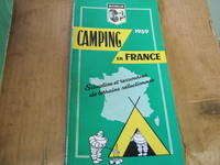
Michelin Camping in France 1959 Situation et Ressources De Terrains selectionnes
- Condition
- Used - Very Good
- Edition
- Third Edition.
- Published
- 1959
- Binding
- Paperback
- Quantity Available
- 1
- Seller
-
Bath, Maine, USA
- Item Price
-
$49.00
Show Details
Description:
Paris: Michelin, 1959 Green/yellow cover art, colored maps, 109 pgs. In French and English Scarce copy. 4to - over 9¾" - 12" tall. 4to - over 9¾" - 12" tall. Third Edition.. Decorative Paper. Very Good. Item Price
$49.00
More Photos
Atlas Colonial Portugues 1909
by Edicao Reduzida 2
- Condition
- Used - Very Good
- Edition
- 1st Edition.
- Published
- 1909
- Binding
- Paperback
- Quantity Available
- 1
- Seller
-
Bath, Maine, USA
- Item Price
-
$735.00
Show Details
Description:
Ministerio Da Marinha e Ultramar - Commissao De Cartographia, 1909 Brown paper covers w/ seal : Commissao de Cartographia top front. Color maps of Portugese colonies in Portugese with data and symbols. Convencoes, Colonias Portuguezas e Paizes de Immigracao, Guine Portugueza, Ilmas de S. Thome E Principe, ect. some spine wear, in original envelope. Signed and Very Rare OCLC finds… Read more about this item Item Price
$735.00
The North American Almanac 1926 the Aristocrat of Almanacs
- Condition
- Used - Very Good
- Edition
- First Edition.
- Published
- 1926
- Binding
- Paperback
- Quantity Available
- 1
- Seller
-
Bath, Maine, USA
- Item Price
-
$17.64
Show Details
Description:
Chicago: The North American Almanac Co, 1926 Scarce Hardcover. Wolf howing at moon cover art, ad for W. B. Hunt Co. Four Stores below wolf. 142 pgs. another 30 or so pages of advertisments. clean tight. First Edition.. Pictorial Cover. Very Good. Item Price
$17.64
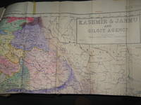
Survey of Pakistan Kashmir
- Condition
- Used - Very Good
- Edition
- 1st Edition
- Published
- 1940
- Binding
- Paperback
- Quantity Available
- 1
- Seller
-
Bath, Maine, USA
- Item Price
-
$980.00
Show Details
Description:
Jammer & Gilgit Agency, 1940 Government of Pakistan Full color Map 1 Inch = 16 miles. Extremely RARE OCLC locates 0 copies. 0 copies LOC. Oblong, no tears, or markings.. Oblong. 1st Edition. Soft cover. Very Good. Item Price
$980.00