H. Books--Travel & Exploration from The Prime Meridian: Antique Maps & Books
New Arrivals
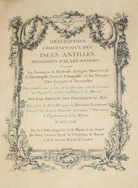
(History of Cartography, Geographic description of the Antilles): Description geographique des isles Antilles possédées par les Anglois
by Bellin, Jacques Nicolas
- Condition
- Used - Very Good
- Edition
- First Edition
- Published
- 1758
- Binding
- Hardcover
- Quantity Available
- 1
- Seller
-
Crozet, Virginia, USA
- Item Price
-
$7,575.00
Show Details
Description:
A Paris: De l'imprimerie de Didot, 1758. This 10.5 inch quarto is in very good condition, sound hinges, 171 pp. with all 22 maps (several folding), plans and views in very good or better condition on heavy paper. Contemporary calf boards with original marbeled pastedowns, two title pages (one decorative with attribution to Bellin), "Tables des Titres" and "Table… Read more about this item Item Price
$7,575.00

The Shape of the World: The Mapping and Discovery of the Earth
by Berthon, S. and Robinson, A
- Condition
- Used
- Quantity Available
- 1
- Seller
-
Crozet, Virginia, USA
- Item Price
-
$25.00
Show Details
Description:
George Philip Ltd., London, 1991. As new w/minimal chipping to dust cover edge due to storage. 4vo., this is the companion volume to Britain's Granada Televion series of the same name. Many beautiful color map reproductions, including sattelite images, dating from the earliest crud e maps to pictures taken from Apollo 8 in 1968. Endpapers are reproductions from major… Read more about this item Item Price
$25.00
(History, Cartography): Geography and Some Explorers
by Conrad, Joseph
- Condition
- Used
- Published
- 1924
- Quantity Available
- 1
- Seller
-
Crozet, Virginia, USA
- Item Price
-
$180.00
Show Details
Description:
Washington DC: The National Geographic Magazine, 1924. This is the complete March 1924 issue, but the article of note is a late article of Joseph Conrad's from pp. 239-274, by the title above. The other articles are all present (vol XLV, number 3). Conrad's article has 13 illustrations, including maps, ships and antarctic views. This article divides the history of… Read more about this item Item Price
$180.00
(History, Colonial America, Norumbega): Discourse on Western Planting, Written in the Year 1584, By Richard Hakluyt
by Hakluyt, Richard (preface by Leonard Woods, edited with notes by Charltes Deane)
- Condition
- Used
- Edition
- First Edition
- Published
- 1877
- Binding
- Hardcover
- Quantity Available
- 1
- Seller
-
Crozet, Virginia, USA
- Item Price
-
$200.00
Show Details
Description:
Cambridge: John Wilson and Son, 1877. This volume was sponsored by the Maine Historical Society, and published as part of the "Documentary History of the State of Maine" vol. II, second series). Dr. Woods had previously been president of Bodin College. Original dark brown cloth, original endpapers, first edition, lxi, 253pp (including index) with the a facsimile of the first… Read more about this item Item Price
$200.00
Description Geographique, Historique et Archeologique De La Palestine Accompagnee De Cartes Detaillees
by Guerin, Victor
- Condition
- Used - Very Good
- Jacket Condition
- No Jacket
- Edition
- Reprint
- Published
- 1969
- Binding
- Hardcover
- Quantity Available
- 1
- Seller
-
Crozet, Virginia, USA
- Item Price
-
$400.00
Show Details
Description:
Amsterdam: Oriental Press, 1969. All 7 volumes are reprints of the 1868 Paris edition. This is a major reference work,(in French) on this region, with several volumes containing folded facsimile maps from the original edition. A few of the covers show some edgewear and rubbing, but generally a very good set with uniformly tight binding and clean text. Appears barely… Read more about this item Item Price
$400.00
Lewis Evans...To Which is Added Evans' A Brief Account of Pennsylvania
by Gipson, Lawrence Henry
- Condition
- Used - Very Good
- Jacket Condition
- No Jacket
- Published
- 1939
- Binding
- Hardcover
- Quantity Available
- 1
- Seller
-
Crozet, Virginia, USA
- Item Price
-
$150.00
Show Details
Description:
Philadelphia: The Historical Society of Pennsylvania, 1939. VG copy of this excellent work. Has 5 facsimle maps: A Map of the Indian walking Purchase, A Map of Pennsylvania, New Jersey, New York..., A Revision of the 1752 Edition of this foregoing Map of 1749, Evans'[ Map of the Middle Atlantic Region..for Peter Kalm..., A Map of the Area in dispute… Read more about this item Item Price
$150.00
The Life and Labors of David Livingstone, LL.D., D.C.L., Covering His Entire Career in Southern and Central Africa
by Chambliss, Rev. J. E
- Condition
- Used
- Quantity Available
- 1
- Seller
-
Crozet, Virginia, USA
- Item Price
-
$130.00
Show Details
Description:
Hubbard Bros., Philadelphia, 1875. 8vo., HB, 853pp, G+ w/ decorative cloth cover. ront cover a bit loose but bindings generally tight. Some soiling and foxing.Over 100 nice b&w steel-plate engravings> Map towards end of text with nice outline color, clean paper, small tear near left side fold not significantly affecting image: Map of Southern and central Africa, Based on… Read more about this item Item Price
$130.00
(History of Cartography): Historical Atlas of the Pacific Northwest
by Hayes, Derek
- Condition
- As New
- Jacket Condition
- As New
- Edition
- First Edition
- Published
- 1999
- Binding
- Hardcover
- Quantity Available
- 1
- Seller
-
Crozet, Virginia, USA
- Item Price
-
$40.00
Show Details
Description:
Seattle: Sasquatch Books, 1999. As new copy of the first edition this wonderful recent production, already increasingly difficult to find. Hard to beat this quality for the price. This has already received rave reviews from several sources, and reproduces 320 maps over four centuries (ranging from Sir Francis Drake's 1579 voyages through the Klondike goldrush and Canadian Pacific Railways maps/surveys).… Read more about this item Item Price
$40.00
(Maps / Charts Mackenzie Basin- Dawson Report- Yukon, Alaska, Canada): Annual Report (New Series) Volume IV. 1888-89 (with 12 sheet map case)
by Selwyn, Alfred R. C. (Director, Geological and Natural History Survey of Canada)
- Condition
- Used - Very Good
- Published
- 1890
- Binding
- Paperback
- Quantity Available
- 1
- Seller
-
Crozet, Virginia, USA
- Item Price
-
$550.00
Show Details
Description:
Montreal : William Foster Brown & Co., 1890. Two volumes; interiors very good or better. A massive production, with the map case covers showing owners plate from the Geological Survey Department, Ottawa, Canada. The map case is chipped and split, but the large folding maps with original printed color are near fine, and include 9 sheets of the Mackenzie Yukon… Read more about this item Item Price
$550.00
(Political, Economic,Historical Descriptions- USA): Description Statistique, Historique et Politique Des Etats-Unis De l'Amerique Septentrionale, Depuis L'epoque Des Premiers Etablissemens...(5 Vols incl.Tardieu Map USA)
by Warden, David Baillie
- Condition
- Used - Very Good
- Edition
- First Edition Thus
- Published
- 1820
- Binding
- Hardcover
- Quantity Available
- 1
- Seller
-
Crozet, Virginia, USA
- Item Price
-
$850.00
Show Details
Description:
Paris: Chez Rey et Gravier, 1820. First French edition (translated from 3 volume 1819 Edinburgh edition), full five thick octavo volumes, early half leather bindings tight with minimal restorations (esp. Vol. 1). Frontispiece of capitol, small folding early city plan of Washington DC, and the scarce map by Tardieu (original hand colored outlines, titled 'Carte des Etats-Unis de L'Amerique Septentrionale',… Read more about this item Item Price
$850.00
(Suez Canal History; Full Text & 5 Maps / Plans): Actes Constitutifs De La Compagnie Universelle Du Canal De Suez
by Compagnie Nouvelle Du Canal De Suez (Count Ferdinand Lesseps)
- Condition
- Used - Very Good
- Published
- 1866
- Quantity Available
- 1
- Seller
-
Crozet, Virginia, USA
- Item Price
-
$695.00
Show Details
Description:
Paris: Henri Plon, 1866. Very good overall, 9 inch 8vo., 146 pp, original endpapers, title and half title, contemporary marbled boards, quarter leather. No major text browning. Small library withdrawl stamp on title page. Covers a bit chipped at the edges. Rebacked with red leather, gilt lettered, 4 band spine in nice condition. All 5 plans present, several very large… Read more about this item Item Price
$695.00
Mexiko. Landskapsbilder Och Skizzer Ur Folklifvit, Affattade I Skrift
by Sartorius, C
- Condition
- Used - Very Good
- Jacket Condition
- No Jacket
- Published
- 1862
- Binding
- Hardcover
- Quantity Available
- 1
- Seller
-
Crozet, Virginia, USA
- Item Price
-
$650.00
Show Details
Description:
Stockholm : PA Huldberg, 1862. Large 8vo., with cover title "Mexiko och Mexikanarne". This is the Swedish edition of this book, with the 18 engraved b&w plates, plus frontispiece. The plates are titled in English, and include the frontal view of Stockholm plus the numerous text views of Mexican coastal and landscape sites, streetviews, monuments, etc. Spine is sunned, rubbed… Read more about this item Item Price
$650.00
(Book-- Cartography, Exploration): The Louisiana Purchase and Our Title West of the Rocky Mountains, with A Review of Annexation by the United States
by Hermann, Binger (Commissioner of the General Land Office)
- Condition
- Used
- Quantity Available
- 1
- Seller
-
Crozet, Virginia, USA
- Item Price
-
$100.00
Show Details
Description:
Gov't Printing Office, Washington DC, 1900. G, large 8vo HB, due to bumped and rubbed cover and early splitting of front interior binding. The book is still reasonably tight (no DJ) and the interior caontents are very good; the 5 maps (4 folding, 3 double page-- Territorial Growth of the Uni ted States, Map by Franquelin in 1684, Moll's… Read more about this item Item Price
$100.00
The First Explorations of the Trans-Allegheny Region By the Virginians 1650-1674
by Alvord, Clarence Walworth; Bidgood, Lee
- Condition
- Used - Very Good
- Jacket Condition
- No Jacket
- Published
- 1912
- Binding
- Hardcover
- Quantity Available
- 1
- Seller
-
Crozet, Virginia, USA
- Item Price
-
$230.00
Show Details
Description:
Cleveland: Arthur H. Clark Company, 1912. Large 8vo, minor rubbing covers, internally in excellent condition. There is a private owner's bookplate pasted inside the front cover. Alvord was at the Univ. of Illinois when he wrote this, with the intent of giving credit to early Virginians in these explorations. Sections include the dicovery of the Ohio waters, discovery of… Read more about this item Item Price
$230.00
(Geographical Text: 7 maps by Thomas Kitchen): A View of the Earth, as Far as it Was Known to the Ancients. Being a Short But Comprehensive System of Classical Geography...Adapted to the Use of Schools and Academies
by Turner, R. Junior
- Condition
- Used
- Published
- 1779
- Quantity Available
- 1
- Seller
-
Crozet, Virginia, USA
- Item Price
-
$950.00
Show Details
Description:
London: J. Dodsley, in Pall-Mall, 1779. Very good overall. Contemporary scuffed leather boards, 8.75 inch 8vo., rebacked with red gilt-lettered spine label and new end-papers. Frontispiece map (The World as far as known to the Ancients), title page, dedication to Francis North (Lord Bishop of Worcester), table of contents, 99 pp text with individual section titles. The other six maps… Read more about this item Item Price
$950.00
Great Britain (Handbook for Travellers)
by Baedeker, Karl
- Condition
- Used
- Published
- 1910
- Quantity Available
- 1
- Seller
-
Crozet, Virginia, USA
- Item Price
-
$30.00
Show Details
Description:
London: T Fisher Unwin, Ltd., 1910. 7th ed. (revised and augmented), original binding. Small 8vo, binding worn and loose w/some damage to upper and lower spine, and some splitting inside front cover. Rest of internal contents VG. the panorama, 28 maps and 65 plans (color printed) are generally VG+. 624pp w/endplate map of Great Britain.. Item Price
$30.00
(King Arthur Legends; Topography and Geography): Arthurian Localities; Their Historical Origin, Chief Country, and Fingalian Relations; with a Map of Arthurian Scotland
by Glennie, John S
- Condition
- Used
- Published
- 1869
- Quantity Available
- 1
- Seller
-
Crozet, Virginia, USA
- Item Price
-
$195.00
Show Details
Description:
Edinburgh: Edmonston and Douglas , 1869. Original dark blue cloth covers scuffed and rubbed; inner hinges starting; small pasted library label at base of spine with upper spine chipped; bookplate of The Minnesota Historical Society on front paste-down, which is beginning to separate. Binding is reasonably tight. Glennie was a barrister and a fellow of the Royal Astronomical Society, and… Read more about this item Item Price
$195.00
Italie Septentrionale Jusqu'a Livourne, Florence et Ravenne
by Baedeker, Karl
- Condition
- Used
- Published
- 1913
- Quantity Available
- 1
- Seller
-
Crozet, Virginia, USA
- Item Price
-
$30.00
Show Details
Description:
Paris: Paul Ollendorff, 1913. Small 8vo, original bindings a bit rubbed, some browning, but generally VG, 36 maps and 36 plans. This is the 18th edition, in French. 690pp + maps/plans. Endplate map of region. Maps generally VG+.. Item Price
$30.00
(Cartographic History): America- 1667
by Bloch, LM (editor)
- Condition
- Used - Very Good
- Jacket Condition
- Good
- Edition
- First Edition
- Published
- 1959
- Binding
- Hardcover
- Quantity Available
- 1
- Seller
-
Crozet, Virginia, USA
- Item Price
-
$60.00
Show Details
Description:
Cleveland: Bloch & Company , 1959. DJ a bit worn and chipped, but servicable. Cloth cover VG with minimal rubbing. Small stamp of "Puritas School" inside of front and rear boards, but no other markings. Interior contents excellent. There are 4 double-page small map reproductions (of Sanson d'Abbeville's) on heavy paper with outline color: North America (Amerique Septentrionale), Canada or… Read more about this item Item Price
$60.00
(Naval History, Britain- 6 maps; 4 volume set): Lives of the Admirals, and Other Eminent British Seamen; Containing Their Personal Histories, and a Detail of All Their Public Services
by Campbell, John (maps by Thomas Jefferys)
- Condition
- Used
- Edition
- 3rd
- Published
- 1761
- Quantity Available
- 1
- Seller
-
Crozet, Virginia, USA
- Item Price
-
$625.00
Show Details
Description:
London: T. Osborne (et al), 1761. All 4 volumes, contemporary banded calf, banded spines (some legibility difficult). Most hinges loose and starting. Gilt-ruled coves. Ex-library with plate of the Theological Seminary Library (Gettysburg, Pa.), with de-acquisition stamp; numerous library markings, including on spine. All 6 folding, copperplate engraved maps by Thomas Jefferys (Europe, Africa, Madagascar & Zanzibar, Asia, North America,… Read more about this item Item Price
$625.00