D. Maps--General from
New Arrivals

(Railroad Map): London and Birmingham Railway
by Stephenson, Robert (engineer)
- Condition
- Used - Very Good
- Edition
- First Edition Thus
- Published
- 1838
- Quantity Available
- 1
- Seller
-
Crozet, Virginia, USA
- Item Price
-
$575.00
Show Details
Description:
London: C. F. Cheffins, 9 Southampton Buildings, 1838. Map with folds as issued, overall very good condition with original hand color, a few fold separations (no image loss) with a couple of partial repairs verso (clear, archival paper tape, so verso text completely legible). Two sheets folded into the stiff, green paper boards (title on boards "Map of the London… Read more about this item Item Price
$575.00
![[World Map, Bible]: A Map of all the Earth and how after the Flood it was divided among the Sons of Noah](https://d3525k1ryd2155.cloudfront.net/h/880/450/438450880.0.m.jpg)
[World Map, Bible]: A Map of all the Earth and how after the Flood it was divided among the Sons of Noah
by Moxon, Joseph
- Condition
- Used
- Published
- 1685
- Quantity Available
- 1
- Seller
-
Crozet, Virginia, USA
- Item Price
-
$1,975.00
Show Details
Description:
Amsterdam: Visscher, Nicholas (Nicolaus), 1685. Very good, early color (perhaps some recent enhancement), few tiny worm holes, minor restoration at lower right (no image loss) and flattened center fold. Minmial browning margins. The date is approximate. Numerous biblical vignettes, some with Hebrew lettering. This was done for a Dutch bible, this one published by Visscher in Amsterday. Shirley's entry… Read more about this item Item Price
$1,975.00
(3 Sheet Map Middle East, Western Asia, India): Imperia Antiqua, pars Orientalis, pars Media, pars Occidentalis
by Bonne Rigobert
- Condition
- Used
- Published
- 1787
- Quantity Available
- 1
- Seller
-
Crozet, Virginia, USA
- Item Price
-
$165.00
Show Details
Description:
Paris: Hotel De Thou, Rue Des Poitevins, 1787. Near fine three-sheet map set, copperplate engravings, b&w as issued, each image measuring approximately 23 x 33 cm. Engraved by Gaspar André. These are sheets 5, 6 and 7 from Bonne and Desmarest's "Atlas Encyclpedique..." Several wind diagrams present. The eastern sheet shows India and "Taprobana" Island. The western sheet shows portions… Read more about this item Item Price
$165.00
(Two Map Set: Roman Empire, east and west sheets): Imperii Romani Distracta, pars Orientalis [and] pars Occidentalis
by Bonne Rigobert
- Condition
- Used
- Published
- 1787
- Quantity Available
- 1
- Seller
-
Crozet, Virginia, USA
- Item Price
-
$135.00
Show Details
Description:
Paris: Hotel De Thou, Rue Des Poitevins, 1787. Near fine, two sheet copperplate engraved set, plates 18 and 19, b&w as issued from the "Atlas Encyclopedique..." by Bonne and Desmarest. Engraved by Gaspar André. A nice wind rose is present on the lower left of sheet 18 (the western sheet). Each image measures approximately 23 x 33 cm.. Item Price
$135.00
(Map of Italy): Italie
by Bonne Rigobert
- Condition
- Used
- Published
- 1787
- Quantity Available
- 1
- Seller
-
Crozet, Virginia, USA
- Item Price
-
$85.00
Show Details
Description:
Paris: Hotel De Thou, Rue Des Poitevins, 1787. Near fine map of Italy from Bonne and Desmarest's "Atlas Encylopedique..." Engraved by Gaspar André. Prime meridians are Paris and the Isle de Fer. Nine separate scales. B&W, as issued. This is plate 51 from the atlas. The copperplate engraved image measures 33 x 23 cm. Sicily, Sardinia and Corsica are shown..… Read more about this item Item Price
$85.00
(Map of Northern Hemisphere): Mappe - Monde, sur le Plan de L'Equateur, Hemisphere Septentrional
by Bonne Rigobert
- Condition
- Used
- Published
- 1787
- Quantity Available
- 1
- Seller
-
Crozet, Virginia, USA
- Item Price
-
$135.00
Show Details
Description:
Paris: Hotel De Thou, Rue Des Poitevins, 1787. Very good, copperplate engraved map, b&w as issued, with some generalized browning. Engraved by Gaspar André. Several tables with climactic information present, and a spherical represenation of climactic zones in the lower right corner. This is plate 22 from the "Atlas Encyclopedique..." by Bonne and Desmarest. The image measures approximately 23 X… Read more about this item Item Price
$135.00
(Map of Spain and Portugal): Le Royaume D'Espagne et celui de Portugal
by Bonne Rigobert
- Condition
- Used
- Published
- 1787
- Quantity Available
- 1
- Seller
-
Crozet, Virginia, USA
- Item Price
-
$85.00
Show Details
Description:
Paris: Hotel De Thou, Rue Des Poitevins, 1787. Near fine copperplate, engraved map, b&w as issued. Engraved by Gaspar André. From Bonne and Desmarest's 1787 "Atlas Encyclopedique..." This is plate 44 from the atlas. Seven separate scales. Prime meridians Paris and Isle de Fer. The image measures 23 x 33 cm.. Item Price
$85.00

(Satirical political map of Franco-Prussian War): Karte von Europa im Jahre 1870 nach einem französischen Holzschnitte
by Hadol (Paul)
- Condition
- Used
- Edition
- First Edition Thus
- Published
- 1914
- Quantity Available
- 1
- Seller
-
Crozet, Virginia, USA
- Item Price
-
$1,875.00
Show Details
Description:
Hamburg: Fuchs, 1914. Very good, on thin paper, with original color, folds as issued (now flattened with some archival tape repair at folds on verso). Mild foxing most evident n lower margin. These maps, often ephemeral in nature, are now all increasingly scarce. Although the date on the map is 1870, it was published by Fuchs ("Verlag von Chs. Fuchs'… Read more about this item Item Price
$1,875.00

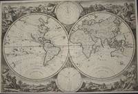
(Old World hemispheric map with climatic zones): Hemisphaerium Orbis Antiqui, Cumzonis, Circulis, Et Situ Populorum Diverso
by Valk, Gerard and Schenk, Petrus [Cellarius, Andreas]
- Condition
- Used
- Published
- 1708
- Quantity Available
- 1
- Seller
-
Crozet, Virginia, USA
- Item Price
-
$2,675.00
Show Details
Description:
Amsterdam: Schenk and Valk, 1708. Very good, minimal foxing, early color copperplate from this 1708 (original version published in 1660 by Jansson) Schenk/Valk issue of (Andreas Cellarius') "Harmonia Macrocosmica Seu Atlas Universalis Et Novus." The striking image measures 41 x 51 cm on a sheet 50 x 59 cm. Numerous cherubim surrond the eastern hemispheric view, which is also divided… Read more about this item Item Price
$2,675.00

(Celestial chart, lunar orbits and eclipses): Theoria Lunae, Eius Motum Per Eccentricum Et Epicyclum Demonstrans
by Valk, Gerard and Schenk, Petrus [Cellarius, Andreas]
- Condition
- Used
- Published
- 1708
- Quantity Available
- 1
- Seller
-
Crozet, Virginia, USA
- Item Price
-
$2,675.00
Show Details
Description:
Amsterdam: Schenk and Valk, 1708. Very good, minimal foxing, early color (with more recent enhancement) copperplate from this 1708 (original version published in 1660 by Jansson) Schenk/Valk issue of (Andreas Cellarius') "Harmonia Macrocosmica Seu Atlas Universalis Et Novus." The striking image measures 43 x 52 cm on a sheet 51 x 60 cm. Numerous cherubim surrond the circular view, as… Read more about this item Item Price
$2,675.00
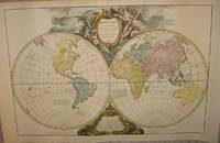
(Word Map): Orbis vetus in utrâque continente juxta mentem Sansonianam distinctus, nec non observationibus astronomicis redactus, accurante
by Robert de Vaugondy, Didier; Robert de Vaugondy, Gilles
- Condition
- Used
- Published
- 1752
- Quantity Available
- 1
- Seller
-
Crozet, Virginia, USA
- Item Price
-
$1,895.00
Show Details
Description:
Paris: apud autorem and Aut. Boudet, 1752. Very good, early hand color, wide margins on laid paper. This is a rather decorative double hemisphere (eastern and western) image.Two watermarks visible verso. Two cartouches upper (title) and lower (notes) central map. The date on the map is 1752, but this is from an "Atlas Universel..." ca. 1757. An image of the… Read more about this item Item Price
$1,895.00

(World Map): Planiglobii terrestris mappa universalis utrumq hemisphærium orient. et occidentale repræsentans ex IV mappis generalibus (Mappe-monde qui represente les deux hemispheres savoir celui de l'orient et celui de l'occident ...
by Homann Heirs (Johann Matthias Hase; G M Lowitz)
- Condition
- Used
- Published
- 1746
- Quantity Available
- 1
- Seller
-
Crozet, Virginia, USA
- Item Price
-
$2,950.00
Show Details
Description:
Nuremberg: Homann Heirs, 1746. Very good, heavy paper, early color, dual hemisphere world map. This is rather decorative, with the four additional smaller polar spheric projections on the map, and two diagrams relating to the position of the sun. Each of the main hemispheric images is 27 cm in diameter, with the full image measuring 46 x 54 cm, on… Read more about this item Item Price
$2,950.00
(WW I, Military): Rand McNally War Map of the French Front Northern Section, A Strategic Map of the Battle Ground in France from St. Mihiel to the Swiss Border Showing the Farthest Advance of the Germans in 1914...Battle Line 1917
by Rand McNally & Co
- Condition
- Used - Very Good
- Published
- 1917
- Binding
- Paperback
- Quantity Available
- 1
- Seller
-
Crozet, Virginia, USA
- Item Price
-
$110.00
Show Details
Description:
Chicago: Rand McNally & Co., 1917. Very good lithographic color, folds as issued, with virtually no fold separations (vertical cut extending approximately 7 inches lower map, without image loss, repaired verso with archival paper tape). Original paper lettered wraps intact. Inset: General War Map, lower left corner. Very detailed, with coded city/town locations verso for France and a small portion… Read more about this item Item Price
$110.00
(WW I, Military): Rand McNally War Map of the French Front Northern Section, A Strategic Map of the Battle Ground in France from St. Quentin to St. Mihiel Showing the Farthest Advance of the Germans in 1914...Battle Line 1917
by Rand McNally & Co
- Condition
- Used - Very Good
- Published
- 1917
- Binding
- Paperback
- Quantity Available
- 1
- Seller
-
Crozet, Virginia, USA
- Item Price
-
$120.00
Show Details
Description:
Chicago: Rand McNally & Co., 1917. Very good lithographic color, folds as issued, with virtually no fold separations. Original paper lettered wraps intact, with rear cover trimmed a bit at outer edge. Inset: General War Map, lower left corner. Very detailed, with coded city/town locations verso for Belgium, Luxemburg and France. The image measures 20.5 x 30.5 inches (52 x… Read more about this item Item Price
$120.00
(World Map from Keur bible): Wereldkaart
by Jagen, Jan Van
- Condition
- Used - Very Good
- Published
- 1748
- Quantity Available
- 1
- Seller
-
Crozet, Virginia, USA
- Item Price
-
$2,950.00
Show Details
Description:
Dordrecht: Keur, 1748. Very good double hemisphere world map from a Keur bible, b&w as issued. The engraver/designer for this map was J. v. Jagen (sculps. et dir.; engraved on lower central edge of plate just inside neatline). Folds as issued. Two smaller spheres upper (Polus Arcticus) and lower (Polus Antarcticus) center. The majority of place names and verso text… Read more about this item Item Price
$2,950.00
(Map) Chart of the Baltic from Admiralty & Russian Surveys
by Desilver, Charles
- Condition
- Used
- Published
- 1856
- Quantity Available
- 1
- Seller
-
Crozet, Virginia, USA
- Item Price
-
$185.00
Show Details
Description:
Philadelphia: Charles Desilver, 1856. Very good lithographed map in original duall-tone color, with the Baltic Sea central to the imate. Decorative border, with image measuring 14.75 x 23.5 inches, and insets of: Cronstadt and St. Petersburg, Sveaborg, Port Baltic, Chart of Reval and Riga. Minimal browning at margins, centerfold as issued, from Desilver's "A New Universal Atlas" in 1856 (largely… Read more about this item Item Price
$185.00
(Map of Middle east- Egypt): Carte De L'Egypt Ancienne
by Joly, Joseph-Romain
- Condition
- Used
- Published
- 1801
- Quantity Available
- 1
- Seller
-
Crozet, Virginia, USA
- Item Price
-
$65.00
Show Details
Description:
Paris (en La Cite): Andre-Augustin Lottin, 1801. VG, scarce, b&w as issued. A nice small view of northern Egypt, with some vague cartographic detail, with the regional course of the Nile River central to the map. Heavy, hand made paper, with folds as issued. Joly was a monk, and a prolific publisher. This is from the scarce "Atlas de L'Ancienne… Read more about this item Item Price
$65.00
(Map of South America): Amerique Meridionale
by Malte-Brun (JJN Huot)
- Condition
- Used
- Published
- 1880
- Quantity Available
- 1
- Seller
-
Crozet, Virginia, USA
- Item Price
-
$60.00
Show Details
Description:
Paris: Garnier Freres, 1880. Very good, hand colored outlines, later Malte-Brun map from "Atlas de Geographie Universelle...". The above date is approximate. The attractive image measures 8.75x12 inches.. Item Price
$60.00
(Map of Europe- Rainfall): Regen-Karte Von Europa
by Berghaus, Heinrich
- Condition
- Used
- Published
- 1850
- Quantity Available
- 1
- Seller
-
Crozet, Virginia, USA
- Item Price
-
$65.00
Show Details
Description:
Gotha: Justus Perthes, 1850. VG+, engraved, hand-colored outlines. Map of European rainfall distribution. Quite elaborate for such a small map. Scarce offering from Berghaus' PHYSIKALISCHER SCHUL-ATLAS... (1850 edition, issued shortly after the second volume of the larger Physikalischer Atlas appeared in 1848). Berghaus was a major force in thematic maps, and these atlases had their orgins in the works… Read more about this item Item Price
$65.00
(Map of Ancient World- 2nd century): Le Monde Donnu Des Anciens
by Vivien De Saint-Martin
- Condition
- Used
- Published
- 1874
- Quantity Available
- 1
- Seller
-
Crozet, Virginia, USA
- Item Price
-
$50.00
Show Details
Description:
Paris: Librairie Hachette et Cie, Boulevard Saint-Germain, 1874. VG, with two-toned printed color and modest topographic detail. Some outline hand-color of various major regions. This is from Vivien's scarce "Atlas Dresse Pour L'Histoire de la Geographie et Decouvertes Geographiques...". A nice, double-folio image measuring 14x18 inches. . Item Price
$50.00