Cartography from William Chrisant & Sons' Florida Book Shop, ABAA, ILAB, FABA
New Arrivals

Systema Solare et Planetarium
by Johann Gabriel Doppelmayr
- Condition
- Used - Very Good
- Published
- 1742
- Quantity Available
- 1
- Seller
-
Fort Lauderdale, Florida, USA
- Item Price
-
$1,000.00
Show Details
Description:
Original hand coloring. The page measures 24 x 20 in, with the image measuring 22 x 19in. Ink stain to center (see image). Separation at centerfold. Item Price
$1,000.00

More Photos
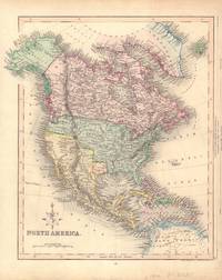
Carta Generale dell' America Settentrionale
by Benedetto Marzolla
- Condition
- Used
- Published
- 1842
- Quantity Available
- 1
- Seller
-
Fort Lauderdale, Florida, USA
- Item Price
-
$1,200.00
Show Details
Description:
A fine impression on bright white paper featuring a blue Republic of Texas and the wishful c. 54-40 oregon border. Paper size: 20.25 x 27.5 inches; image size: 15.75 x 19.75 inches. Closed tear to top far from imprint (see image). Item Price
$1,200.00

More Photos
Carte Reduite du Golphe du Mexique et des Isles de l'Amerique.
by Jacques Nicolas Bellin
- Condition
- Used
- Edition
- Second
- Published
- 1774
- Quantity Available
- 1
- Seller
-
Fort Lauderdale, Florida, USA
- Item Price
-
$3,330.00
Show Details
Description:
This is the second edition of Bellin's original of 1749 but whereas the earlier map rightly showed Florida as a peninsula, this second edition portrays it an archipelago, each island with its own distinctive coast. Seal of the prestigious Depot de la Marine to lower left. Overall 60 x 80 cm; 23.5 x 31.5 inches. Item Price
$3,330.00

More Photos
Peutingeriana tabula itineraria : ex Bibliotheca Caesarea Vindobonensi cura Franc. Christ. de Scheyb edita MDCCLIII.
by Matija Katancic after Franz Christoff Scheyb
- Condition
- Used - Very Good
- Published
- 1825
- Quantity Available
- 1
- Seller
-
Fort Lauderdale, Florida, USA
- Item Price
-
$2,200.00
Show Details
Description:
Twelve hand-colored 45 x 60.4 cm sheets. Sheets previously folded with some loss to fold intersections; green coloring oxidized to olive-brown in plates 2-8 (see images). Each sheet corner-mounted on acid free 20 x29 inch mat with mylar cover and mat overlay. Item Price
$2,200.00

More Photos
Asia. Constructed & Engraved By W. & A.K. Johnston, Limited. Geographers, Engravers & Printers.
by W. & A.K. Johnston
- Condition
- Used
- Quantity Available
- 1
- Seller
-
Fort Lauderdale, Florida, USA
- Item Price
-
$3,200.00
Show Details
Description:
Modified Orthographic Projection. A well preserved large format (nearly 5 x 6 feet) map of post World War I Asia. Slight foxing, otherwise a remarkably well preserved image of the Asian continent. Four joined sheets with overall fine linen backing; attached to a springed roller bar and so spared ever being folded. (image: 180 cm (71 inches) wide x… Read more about this item Item Price
$3,200.00

Europe. Constructed & Engraved by W. & A.K. Johnston, Limited. Geographers, Engravers & Printers.
by W. & A.K. Johnston
- Condition
- Used
- Published
- . 1928
- Quantity Available
- 1
- Seller
-
Fort Lauderdale, Florida, USA
- Item Price
-
$1,400.00
Show Details
Description:
A remarkably well preserved large format (nearly 5 x 6 feet) map of post World War I Europe. Slight foxing, otherwise a remarkably well preserved image of the European continent. Four joined sheets with overall fine linen backing on a roller & so without folds. Modified Orthographic Projection. (image: 180 cm (71 inches) wide x 155 cm (61 inches) high.… Read more about this item Item Price
$1,400.00

Moscovy. Corrected from ye Observations communicated to the Royal Society of London and Paris
by John Senex
- Condition
- Used
- Edition
- First Edition
- Published
- 1712
- Quantity Available
- 1
- Seller
-
Fort Lauderdale, Florida, USA
- Item Price
-
$1,500.00
Show Details
Description:
Large two panel conjoined full original color map published during the reign of Peter the Great. Archival reinforcement at folds. Item Price
$1,500.00

More Photos
L' Empire du Japon, divise en sept principales parties, et subdivise en soixante et six Royaumes.
by Robert Vaugondy
- Condition
- Used - Very Good
- Published
- 1750
- Quantity Available
- 1
- Seller
-
Fort Lauderdale, Florida, USA
- Item Price
-
$500.00
Show Details
Description:
Map of Japan dry-mounted to acid free foam-board. Original hand coloring in outline.
Image size: 21 x 19 in
Paper size: 26.25 x 20 in
Board size: 28.75 x 27.25 in Item Price
$500.00

More Photos
Exposition de la Cartographie Belge aux XVI, XVII, et XVIII Siecles, Organisee au Musee Plantin-Moretus a l'ocassion du Cinquantenaire de la Societe Royale de Geographie d'Anvers. Tentoonstelling van de Belgische Kaartmalerskunde.
by Fernand van Ortroy
- Condition
- Used - Very Good
- Published
- 1926
- Quantity Available
- 1
- Seller
-
Fort Lauderdale, Florida, USA
- Item Price
-
$110.00
Show Details
Description:
An attractive full dark blue polished calf with gilt title and designs to spine. Written in French and Dutch. Gilt borders to covers. Five raised bands. Marbled endpapers. Black and white plates, some of which fold-out. No previous owner's names or other markings. Pp. [lv] 59
7.5 x 10.5 Item Price
$110.00
More Photos
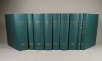
Geographical Atlases in the Library of Congress
by Philip Lee Phillips, F. R. G. S.
- Condition
- Used - Fine
- Edition
- Limited Edition
- Quantity Available
- 1
- Seller
-
Fort Lauderdale, Florida, USA
- Item Price
-
$275.00
Show Details
Description:
Nine volume set. Limited edition facsimile of the original 1909 edition. Green cloth with gilt titles on spines. A nice clean set with no previous owner's names or other markings. This set was a multiple bought by us when published and never used. Please expect extra postage.
7.25 x 9 in Item Price
$275.00

The Road from Glocester to Coventrey
by John Ogilby
- Condition
- Used - Very Good
- Published
- C. 1675
- Quantity Available
- 1
- Seller
-
Fort Lauderdale, Florida, USA
- Item Price
-
$305.00
Show Details
Description:
Hand colored map. 19 1/4 15 1/4 inches. Item Price
$305.00

More Photos
La Louisiana, Parte Settentrionalle, Scoperta sotto la Protettione di Luigi XIV, Ré di Francia, etc. Descritta, e Dedicata.
by Vincenzo Maria Coronelli
- Condition
- Used
- Edition
- First Edition
- Published
- c 1695
- Quantity Available
- 1
- Seller
-
Fort Lauderdale, Florida, USA
- Item Price
-
$6,000.00
Show Details
Description:
Burden, 701. River de Chekagou as eponym for Chicago. An unusually exact 17th century portrayal of the Great Lakes albeit with such anomalies as an alligator's eating one of the indigenous folk near the border of later day Minnesota and Canada. Neatline: 26 x 42 cm. This map is archivally framed in ruled mahogany with removable… Read more about this item Item Price
$6,000.00
More Photos
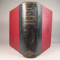
The Discovery of North America, A Critical, Documentary, and Historic Investigation,
by Henry Harrisse
- Condition
- Used - Very Good
- Edition
- First Edition
- Published
- 1892
- Quantity Available
- 1
- Seller
-
Fort Lauderdale, Florida, USA
- Item Price
-
$1,450.00
Show Details
Description:
Quarter morocco over pictorial maroon cloth board with gilt particulars to spine. Top edge gilt. Limited edition copy No. 91 of 380 issued, this being the English Toned Paper edition. Hors textes plates with tissue guards throughout. Black and white illustrations throughout text as well. Title continued: "to which are added a chronology of one hundred voyages westward, projected, attempted,… Read more about this item Item Price
$1,450.00
Hand-Colored Map of North America (Texas as an Independent Republic)
by James Gilbert
- Condition
- Used - Very Good
- Edition
- First Edition
- Published
- ca. 1840
- Quantity Available
- 1
- Seller
-
Fort Lauderdale, Florida, USA
- Item Price
-
$850.00
Show Details
Description:
A nice, clean engraving in original hand-color. Measures 10 3/8 x 13 in. Item Price
$850.00
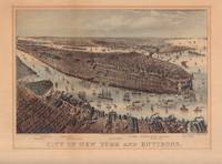
City of New York and Environs.
- Condition
- Used - Very Good
- Published
- 1875
- Quantity Available
- 1
- Seller
-
Fort Lauderdale, Florida, USA
- Item Price
-
$1,200.00
Show Details
Description:
Hand-colored lithograph. Mat burn to edges (see image). 12.2 x 17 in, image size 8 1/2 x 13 1/16, frame 17.9 x 14 in. Item Price
$1,200.00
More Photos
Descriptio orbis antiqui in XLIV tabulis.
by Johann Davide Koelero, John David Kohler. Koehler. Christoph Weigel.
- Condition
- Used
- Edition
- First Edition
- Published
- 1720
- Quantity Available
- 1
- Seller
-
Fort Lauderdale, Florida, USA
- Item Price
-
$3,000.00
Show Details
Description:
Full limp calf. Engraved title & forty-four double page hand colored maps, plans and views on stout paper. Plate 1 (Eastern hemisphere map) separated at fold; Plates 2 & 3 (Europe & Iberia) top dampstained; map of Roman Britain rather poorly colored. Occasional splits at gutter fold (please ask for details); thumbing. 355 x 240 mm. Ex… Read more about this item Item Price
$3,000.00