Description:
Vanity Fair, April 20, 1878. Drawn by Spy. Original chromolithograph. Page size approx. 38 x 26.5cm. Image size approx. 31 x 18.5cm. With original leaf of biographical text.
Search Results: Authors starting with N from Robert Frew Ltd
You searched for:
- Bookseller inventory: Robert Frew Ltd (authors starting with N)
- Bookseller: Robert Frew Ltd
Results 1 - 20 of 282

the British Expedition". Men of the Day. No. 177.
by NAPIER, General Lord of Magdala.
- Used
- Condition
- Used
- Quantity Available
- 1
- Seller
-
London, London, United Kingdom
- Item Price
-
$31.60$11.31 shipping to USA
Show Details
Item Price
$31.60
$11.31
shipping to USA
L'Indicateur g�n�ral. Ile Ste H�l�ne.
by (NAPOLEON)
- Used
- Condition
- Used
- Quantity Available
- 1
- Seller
-
London, London, United Kingdom
- Item Price
-
$315.95$11.31 shipping to USA
Show Details
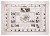
Description:
[c.1842]. Map of St. Helena surrounded by 11 vignettes of scenes documenting Napoleans time on the island, further surrounded by 22 portaits in medallions of Napoleon's generals on his various campaigns, engraved by Doornich. (Overall 60 x 85 cm.) 3 vertical creases. Imprint scratched out.
Item Price
$315.95
$11.31
shipping to USA

Napol�on et son �poque
by [NAPOLEON]
- Used
- Condition
- Used
- Quantity Available
- 1
- Seller
-
London, London, United Kingdom
- Item Price
-
$473.92$11.31 shipping to USA
Show Details
Description:
Paris Typographie de Firmin-Didot Fr�res, Rue Jacob, no. 24 [c. 1835]. 97 x 65 cm. Divided into 17 sections detailing aspects of Napoleons life and legacy, each of which has been given a water-colour wash. A portrait of a statue of Napoleon features prominently in the upper-central portion of the print, along with three small vignettes. Framed by a decorative border. Damage to the lower right-hand corner, and a slight tear near the upper-mid portion. 4th �dition. �diteur: C. Pain, Place Dauphine, no. 13.
Item Price
$473.92
$11.31
shipping to USA

Plon-Plon". Princes. No. 7.
by NAPOLEON, Jerome, Prince.
- Used
- Condition
- Used
- Quantity Available
- 1
- Seller
-
London, London, United Kingdom
- Item Price
-
$25.28$11.31 shipping to USA
Show Details
Description:
Vanity Fair, July 26, 1879. Drawn by T. Original chromolithograph. Page size approx. 38 x 26.5cm. Image size approx. 31 x 18.5cm. With original leaf of biographical text.
Item Price
$25.28
$11.31
shipping to USA

Mansions of England in the Olden Time. Re-edited by J. Corbett Andersen with the original one hundred and four illustrations carefully reduced and executed in lithography by M & N. Hanhart.
by NASH, Joseph.
- Used
- Hardcover
- Condition
- Used
- Binding
- Hardcover
- Quantity Available
- 1
- Seller
-
London, London, United Kingdom
- Item Price
-
$8,214.70$11.31 shipping to USA
Show Details
Description:
London: Henry Sotheran, 1869-1872.. 4 large portfolios (57 x 47 cm) . Vol I: printed title page, list of illustrations, pp.16 text, lithographed title and 25 plates ; Vol II: printed title page, pp.17-32 text, lithographed title and 25 plates; Vol III: printed title page, p.35-55 text, lithographed title and 25 plates; Vol IV: printed title, pp.59-74 text, lithographed title and 25 plates. In original morocco-backed green cloth boards, gilt titles on upper covers, spines renewed. Altogether 106 fine hand coloured lithograph plates (c. 19 x 25 cm.) mounted on 104 leaves (2 leaves with 2 plates per leaf) , three backing sheets renewed. Intermittent light marginal spotting and soiling, a few corners and extremities slightly worn, generally very good. The Mansions' combination of architectural and antiquarian accuracy with contemporary values was incredibly effective. Nash's plates were immediately engraved for mass circulation in the Saturday Magazine and widely copied and plagiarized in the popular…
Read More Item Price
$8,214.70
$11.31
shipping to USA

Africa and the Arabian Penninsula Compiled and Drawn in the Cartographic Section of the National Geographic Society for the National Geographic Magazine, Gilbert Grosvenor, Editor. Chamberlain Trimetric Projection, Scale 1:12,000,000 or 189.4 Miles to the Inch.
by [NATIONAL GEOGRAPHIC], GROSVENOR, Gilbert (ed.)
- Used
- Condition
- Used
- Quantity Available
- 1
- Seller
-
London, London, United Kingdom
- Item Price
-
$126.38$11.31 shipping to USA
Show Details
Description:
Baltimore, Md: Printed by A. Hoen and Co., Lithographers. March 1950.. Colour printed map of Africa and the Arabian Penninsula (78 x 72 cm) folding to 24 x 16 cm. Showing railways, roads, caravan routes, canals, oil pipelines, oil fields, wells, airports, ruins, passes, sandy desert, dry salt lakes, wadies, areas below sea level, volcanic debris, heights in feet. Inset map of Cape Verde Islands and inset physical map of Africa. Old fold creases, trivial light browning to bottom right corner. Generally a very good example. "Gilbert Grosvenor was elected president of the National Geographic Society in 1920. During his administration, greatly increased revenues enabled the society to send out numerous expeditions to the North and South poles, into the stratosphere, and to the ocean depths and to conduct a myriad of other investigations." (Britannica)
Item Price
$126.38
$11.31
shipping to USA

The Philippines Compiled and Drawn in the Cartographic Section of the National Geographic Society for the National Geographic Magazine, Gilbert Grosvenor, Editor. Polyconic Projection, Scale 1:3,000,000 or 47.35 Miles to the Inch.
by [NATIONAL GEOGRAPHIC], GROSVENOR, Gilbert (ed.)
- Used
- Condition
- Used
- Quantity Available
- 1
- Seller
-
London, London, United Kingdom
- Item Price
-
$63.19$11.31 shipping to USA
Show Details
Description:
Baltimore, Md: Lithographed by A. Hoen and Co. March 1945.. Colour printed map of The Philippines (65.5 x 44.5 cm) folding to 22.5 x 16.5 cm. Showing railways, roads, airfields, provincial capitals. Also with inset maps of Manila, Lingayen Gulf and Location Map of the Philippines. Old fold creases, generally an excellent example. "Gilbert Grosvenor was elected president of the National Geographic Society in 1920. During his administration, greatly increased revenues enabled the society to send out numerous expeditions to the North and South poles, into the stratosphere, and to the ocean depths and to conduct a myriad of other investigations." (Britannica)
Item Price
$63.19
$11.31
shipping to USA

Western Soviet Union Compiled and Drawn in the Cartographic Section of the National Geographic Society for the National Geographic Magazine, Melville Bell Grosvenor, Editor.Transverse Mercator Projection, Scale 1:6,336,000 or 100 Miles to the Inch.
by [NATIONAL GEOGRAPHIC], GROSVENOR, Melville Bell (ed.)
- Used
- Condition
- Used
- Quantity Available
- 1
- Seller
-
London, London, United Kingdom
- Item Price
-
$31.60$11.31 shipping to USA
Show Details
Description:
Baltimore, Md: Lithographed by A. Hoen and Co. September 1959. Colour printed map of the Western Soviet Union (63 x 48 cm) folding to 24.5 x 16 cm. Showing railroads, roads, places with scheduled air service, canals, oil pipe lines, oil fields, ruins, desert, tundra, swamp. Old fold creases, trivial browning along some folds. Generally in excellent condition.
Item Price
$31.60
$11.31
shipping to USA

Bible Lands and the Cradle of Western Civilisation Compiled and Drawn in the Cartographic Section of the National Geographic Society for the National Geographic Magazine, Gilbert Grosvenor, Editor. Conical Projection, Scale 1:3,000,000 or 47.35 Miles to the Inch.
by [NATIONAL GEOGRAPHIC], GROSVENOR, Gilbert (ed.)
- Used
- Condition
- Used
- Quantity Available
- 1
- Seller
-
London, London, United Kingdom
- Item Price
-
$126.38$11.31 shipping to USA
Show Details
Description:
Baltimore, Md: Lithographed by A. Hoen and Co. December 1938.. Colour printed map of the Bible Lands and the Cradle of Western Civilisation (84 x 63 cm) folding to 22 x 16 cm. Showing capitals of countries, other capitals, cities and towns, ruins, principal archaeological sites, railways, airways, desert bus routes, oil fields, oil pipe lines, pumping stations, battles, passes, canals, swampy regions, volcanic debris, areas below sea level, areas subject to inundation, sandy deserts and dunes. Also with historical and biblical inset maps showing Jerusalem, The Holy Land, Economic Development, Route of the Exodus, St. Paul's Travels, The Crusades, Alexander the Great (boundary of empire and route of army). Old fold creases, some trivial tearing to bottom left corner. Generally a very good example. "Gilbert Grosvenor was elected president of the National Geographic Society in 1920. During his administration, greatly increased revenues enabled the society to send out numerous expeditions to the…
Read More Item Price
$126.38
$11.31
shipping to USA

Asia and Adjacent Areas Compiled and Drawn in the Cartographic Section of the National Geographic Society for the National Geographic Magazine, Gilbert Grosvenor, Editor. Scale 1:17,500,000 or 276.2 Miles to the Inch.
by [NATIONAL GEOGRAPHIC], GROSVENOR, Gilbert (ed.)
- Used
- Condition
- Used
- Quantity Available
- 1
- Seller
-
London, London, United Kingdom
- Item Price
-
$126.38$11.31 shipping to USA
Show Details
Description:
Baltimore, Md: Lithographed by A. Hoen and Co. December 1942.. Colour printed map of Asia and Adjacent Areas (101 x 66.5 cm) folding to 25 x 16 cm. Showing capitals, canals, ruins, passes, relief, principal railways, oil pipe lines, important roads, trails, railways underconstruction, Great Wall of China, areas below sea level, deserts, glaciers. International borders are "as of September 1, 1939, the day Germany invaded Poland". Old fold creases, trivial tears at folds, minor light browning. Generally a very good example. "Gilbert Grosvenor was elected president of the National Geographic Society in 1920. During his administration, greatly increased revenues enabled the society to send out numerous expeditions to the North and South poles, into the stratosphere, and to the ocean depths and to conduct a myriad of other investigations." (Britannica)
Item Price
$126.38
$11.31
shipping to USA

Countries of the Caribbean Including Mexico, Central America and the West Indies Compiled and Drawn in the Cartographic Section of the National Geographic Society for the National Geographic Magazine, Gilbert Grosvenor, Editor. Transverse Mercator Projection, Scale 1:6,000,000 or 94.7 Miles to the Inch.
by [NATIONAL GEOGRAPHIC], GROSVENOR, Gilbert (ed.)
- Used
- Condition
- Used
- Quantity Available
- 1
- Seller
-
London, London, United Kingdom
- Item Price
-
$126.38$11.31 shipping to USA
Show Details
Description:
Baltimore, Md: Printed by A. Hoen and Co., Lithographers. October 1947.. Colour printed map of Countries of the Caribbean Including Mexico, Central America and the West Indies (103.5 x 63 cm) folding to 21.5 x 16 cm. Showing principal railways, roads, Pan-American highway, canals, ruins, airports with scheduled transport service, elevation and depths in feet. Inset maps of Trinidad, Jamaica, Cuba, Exuma (Bahama 15.), St. Lucia, Antigua, Bermuda Islands, Puerto Rico, St. Thomas & St. John, St. Croix, Canal Zone. Old fold creases, trivial light browning along some folds. Trivial tearing. Generally a very good example. "Gilbert Grosvenor was elected president of the National Geographic Society in 1920. During his administration, greatly increased revenues enabled the society to send out numerous expeditions to the North and South poles, into the stratosphere, and to the ocean depths and to conduct a myriad of other investigations." (Britannica)
Item Price
$126.38
$11.31
shipping to USA

Mexico, Central America and The West Indies Compiled and Drawn in the Cartographic Section of the National Geographic Society for the National Geographic Magazine, Gilbert Grosvenor, Editor. Conformal Conic Projection, Scale 1:5,702,400 or 90 Miles to the Inch.
by [NATIONAL GEOGRAPHIC], GROSVENOR, Gilbert (ed.)
- Used
- Condition
- Used
- Quantity Available
- 1
- Seller
-
London, London, United Kingdom
- Item Price
-
$94.78$11.31 shipping to USA
Show Details
Description:
Baltimore, Md: Lithographed by A. Hoen and Co. December 1939.. Colour printed map of Mexico, Central America and The West Indies (103 x 60.5 cm) folding to 21 x 15.5 cm. Showing capitals of countries, other capitals, cities and towns, ruins, highways, Inter-American Highways, railways, canals, mountains, swampy regions, areas subject to inundation. With inset maps of Jamaica, Cuba, Bermuda Islands, Puerto Rico and the Virgin Islands, Saint Thomas, Isthmus of Panama. Old fold creases, some minor spotting, some trivial nicks along folds. Generally a very good example. "Gilbert Grosvenor was elected president of the National Geographic Society in 1920. During his administration, greatly increased revenues enabled the society to send out numerous expeditions to the North and South poles, into the stratosphere, and to the ocean depths and to conduct a myriad of other investigations." (Britannica)
Item Price
$94.78
$11.31
shipping to USA

Southwest Asia, India, Pakistan and Northeast Africa Compiled and Drawn in the Cartographic Section of the National Geographic Society for the National Geographic Magazine, Gilbert Grosvenor, Editor. Albers Conical Equal-Area Projection, Scale 1:7,500,000 or 118.4 Miles to the Inch.
by [NATIONAL GEOGRAPHIC], GROSVENOR, Gilbert (ed.)
- Used
- Condition
- Used
- Quantity Available
- 1
- Seller
-
London, London, United Kingdom
- Item Price
-
$189.57$11.31 shipping to USA
Show Details
Description:
Baltimore, Md: Lithographed by A. Hoen and Co. June 1952.. Colour printed map of Southwest Asia, India, Pakistan and Northeast Africa also showing the Arabian Peninsula and parts of Central Asia and Eastern Europe (95 x 67 cm) folding to 24 x 17 cm. Showing principal railways, roads, oil pipe lines, oil fields, canals, water holes, principal airports, passes, ruins, volcanic debris, areas below sea level, dry salt lakes, elevations in feet. Also with inset map titled The Moslem World. Old fold creases, browning to upper-right and along some folds. Some nicks, small tear to upper-right along fold. "Gilbert Grosvenor was elected president of the National Geographic Society in 1920. During his administration, greatly increased revenues enabled the society to send out numerous expeditions to the North and South poles, into the stratosphere, and to the ocean depths and to conduct a myriad of other investigations." (Britannica)
Item Price
$189.57
$11.31
shipping to USA

Eastern South America: Brazil, Paraguay, Uruguay, and the Guianas Compiled and Drawn in the Cartographic Section of the National Geographic Society for the National Geographic Magazine,John Oliver La Gorce, Editor. Chamberlin Trimetric Projection, Scale 1:5,000,000 or 78.91 Miles to the Inch.
by [NATIONAL GEOGRAPHIC], LA GORCE, John Oliver (ed.)
- Used
- Condition
- Used
- Quantity Available
- 1
- Seller
-
London, London, United Kingdom
- Item Price
-
$63.19$11.31 shipping to USA
Show Details
Description:
Baltimore, Md: Lithographed by A. Hoen and Co. March 1955.. Colour printed map of Eastern South America: Brazil, Paraguay, Uruguay, and the Guianas (103 x 73.5 cm) folding to 24.5 x 15.5 cm. Showing railways, roads, Pan American Highway, airports, oil fields, oil pipe lines, elevations in feet, depth curves and soundings in fathoms. Also with inset maps showing Continuation of Brazil on Same Scale as Main Map and Rio de Janeiro. Old fold creases, minor browning and trivial nicks along some folds. Generally a very good example.
Item Price
$63.19
$11.31
shipping to USA

Europe and the Near East Russian and Polish boundaries according to treaties and claims as of April 1, 1949, Compiled and Drawn in the Cartographic Section of the National Geographic Society for the National Geographic Magazine, Gilbert Grosvenor, Editor. Chamberlain Trimetric Projection, Scale 1:7,500,000 or 118.4 Miles to the Inch.
by [NATIONAL GEOGRAPHIC], GROSVENOR, Gilbert (ed.)
- Used
- Condition
- Used
- Quantity Available
- 1
- Seller
-
London, London, United Kingdom
- Item Price
-
$63.19$11.31 shipping to USA
Show Details
Description:
Baltimore, Md: Lithographed by A. Hoen and Co. June 1949.. Colour printed map of Europe and the Near East (81.5 x 72 cm) folding to 21 x 14.5 cm. Showing occupation zones in Germany and Austria during World War II (American, British, French, Russian), principal railways, canals, oil pipelines, oil fields, water holes, ruins, passes, desert, areas below sea level, volcanic debris, dry salt lakes, swamps, wadies, elevations. Old fold creases, trivial light browning along one fold. Generally an excellent example. "Gilbert Grosvenor was elected president of the National Geographic Society in 1920. During his administration, greatly increased revenues enabled the society to send out numerous expeditions to the North and South poles, into the stratosphere, and to the ocean depths and to conduct a myriad of other investigations." (Britannica)
Item Price
$63.19
$11.31
shipping to USA

Canada, Alaska & Greenland Compiled and Drawn in the Cartographic Section of the National Geographic Society for the National Geographic Magazine, Gilbert Grosvenor, Editor. Chamberlin Trimetric Projection, Scale 1:8,000,000 or 126.3 Miles to the Inch.
by [NATIONAL GEOGRAPHIC], GROSVENOR, Gilbert (ed.)
- Used
- Condition
- Used
- Quantity Available
- 1
- Seller
-
London, London, United Kingdom
- Item Price
-
$63.19$11.31 shipping to USA
Show Details
Description:
Baltimore, Md: Lithographed by A. Hoen and Co. June 1947.. Colour printed map of Canada, Alaska & Greenland (87.5 x 67 cm) folding to 22 x 17 cm. Showing principal railways, roads, canals, passes, winter tractor trails, northern limit of wooded country, principal airports, elevations in feet. Inscription in blue ink, "Braloane (Elizabeth)" with line pointing to Braloane, BC. Black ink inscription "Shepherd Bay" with arrow to upper margin. Some additional annotations to map in blue ink. Old fold creases, some toning throughout and browning along folds, with some nicks. "Gilbert Grosvenor was elected president of the National Geographic Society in 1920. During his administration, greatly increased revenues enabled the society to send out numerous expeditions to the North and South poles, into the stratosphere, and to the ocean depths and to conduct a myriad of other investigations." (Britannica)
Item Price
$63.19
$11.31
shipping to USA

Africa Compiled and Drawn in the Cartographic Section of the National Geographic Society for the National Geographic Magazine, Gilbert Grosvenor, Editor. Azimuthal Equal-Area Projection, Scale 1:11,721,600 or 185 Miles to the Inch.
by [NATIONAL GEOGRAPHIC], GROSVENOR, Gilbert (ed.)
- Used
- Condition
- Used
- Quantity Available
- 1
- Seller
-
London, London, United Kingdom
- Item Price
-
$126.38$11.31 shipping to USA
Show Details
Description:
Baltimore, Md: Lithographed by A. Hoen and Co. February 1943.. Colour printed map of Africa with parts of southern Europe and the Middle East (79 x 74.5 cm) folding to 24.5 x 16 cm. Showing capitals of countries, other capitals, cities and towns, ruins, wells and springs, canals, railways, automobile routes, caravan routes, mountains, passes, sandy deserts, areas below sea level, swampy regions, areas subject to inundation, wadies, oil pipe lines, elevations in feet. Inset relief map of Africa and inset map of Cape Verde Islands. International borders are "as of September 1, 1939, the day Germany invaded Poland". Minor light browning to margins and some folds. Generally a very good example "Gilbert Grosvenor was elected president of the National Geographic Society in 1920. During his administration, greatly increased revenues enabled the society to send out numerous expeditions to the North and South poles, into the stratosphere, and to the ocean depths and to conduct a myriad of other…
Read More Item Price
$126.38
$11.31
shipping to USA

Lands of the Bible Today, with Historical Notes Compiled and Drawn in the Cartographic Section of the National Geographic Society for the National Geographic Magazine, John Oliver La Gorce, Editor. Conic Projection, Scale 1:2.851,200 or 45 Miles to the Inch.
by [NATIONAL GEOGRAPHIC], LA GORCE, John Oliver (ed.)
- Used
- Condition
- Used
- Quantity Available
- 1
- Seller
-
London, London, United Kingdom
- Item Price
-
$126.38$11.31 shipping to USA
Show Details
Description:
Baltimore, Md: Lithographed by A. Hoen and Co. December 1956.. Colour printed map of Lands of the Bible Today (73.5 x 103 cm) folding to 24.5 x 16 cm. Showing roads, railways, canals, principal archaeological sites, ruins, battles, oil fields, oil pipe lines, refineries, pumping stations, water holes, passes, airports, elevations in feet, soundings in fathoms. With inset maps showing Holy Land Today, Jerusalem, Traditional Route of the Exodus, St. Paul's Four Great Journeys, The Crusades. Also with copious explanatory notes detailing points of Biblical and historical interest across the map. Old fold creases, trivial browning along some folds. Generally in excellent condition.
Item Price
$126.38
$11.31
shipping to USA

Central Europe Including the Balkan States Compiled and Drawn in the Cartographic Section of the National Geographic Society for the National Geographic Magazine, Gilbert Grosvenor, Editor. Albers Conical Equal-Area Projection, Scale 1:2,500,000 or 39.46 Miles to the Inch.
by [NATIONAL GEOGRAPHIC], GROSVENOR, Gilbert (ed.)
- Used
- Condition
- Used
- Quantity Available
- 1
- Seller
-
London, London, United Kingdom
- Item Price
-
$63.19$11.31 shipping to USA
Show Details
Description:
Baltimore, Md: Lithographed by A. Hoen and Co. September 1951.. Colour printed map of Central Europe and the Balkan States (96.5 x 73 cm) folding to 24.5 x 16 cm. Showing occupation zones in Germany and Austria, World War II (American, British, French, Russian). Russian and Polish boundaries are shown "according to treaties and claims as of July 1, 1951". Also showing principal railways, highways, autobahn, canals, oil pipe lines, oil fields, principal airports, passes, ruins. Old fold creases, minor light browning along some folds. Generally an excellent example. "Gilbert Grosvenor was elected president of the National Geographic Society in 1920. During his administration, greatly increased revenues enabled the society to send out numerous expeditions to the North and South poles, into the stratosphere, and to the ocean depths and to conduct a myriad of other investigations." (Britannica)
Item Price
$63.19
$11.31
shipping to USA

Southeast Asia and Pacific Islands from the Indies and the Philippines to the Solomons Compiled and Drawn in the Cartographic Section of the National Geographic Society for the National Geographic Magazine, Gilbert Grosvenor, Editor. Transverse Mercator Projection, Scale 1:8,000,000 or 126 Miles to the Inch.
by [NATIONAL GEOGRAPHIC], GROSVENOR, Gilbert (ed.)
- Used
- Condition
- Used
- Quantity Available
- 1
- Seller
-
London, London, United Kingdom
- Item Price
-
$126.38$11.31 shipping to USA
Show Details
Description:
Baltimore, Md: Printed by A. Hoen and Co., Lithographers. October 1944.. Colour printed map of Southeast Asia (104 x 66.5 cm) folding to 23 x 17 cm. Showing principal railroads, important roads, oil pipelines, airfields, elevations and depths. Boundaries as of September 1st, 1939. Inset maps of Shanghai, Hong Kong, Singapore, Soerabaja, Manila, Davao, Saipan and Tinian, Guam, Rota, Pescadores, Nansei Islands, Iwo Jima, Pratas, Palau Islands, Yap, Truk Islands, Chichi Jima Retto, Haha Jima Retto, Ponape, Eniwetok, Marcus. Old fold creases, trivial tear along fold in margin of upper right hand, not affecting map, minor light browning along some folds. Generally a very good example. "Gilbert Grosvenor was elected president of the National Geographic Society in 1920. During his administration, greatly increased revenues enabled the society to send out numerous expeditions to the North and South poles, into the stratosphere, and to the ocean depths and to conduct a myriad of other investigations." (Britannica)
Item Price
$126.38
$11.31
shipping to USA

Didn’t find what you’re looking for?
Try adding this search to your want list. Millions of books are added to our site everyday and when we find one that matches your search, we’ll send you an email. Best of all, it’s free.
Add to Want List

Are you a frequent reader or book collector?
Join the Bibliophile's Club and save 10% on every purchase, every day — up to $20 savings per order!

Social Responsibility
Did you know that since 2004, Biblio has used its profits to build 16 public libraries in rural villages of South America?