Description:
MAP OF RED MOUNTAINMINING DISTRICT,OURAY COUNTY,COLORADOByW. A. SHERMAN,MINING ENGINEER1891CopyrightedRand McNally & Company,Engravers, ChicagoScale: 1 inch = 1000 feetDimensions:35 inches by 21-1/2 inchesCondition: very good to very good plus; some light patina almost evenly spread throughout original map; minor conservation repair in several places.COLORADO ARTIFACTUAL
Search Results: Titles starting with M from Mt. Gothic Tomes & Colorado Artifactual
You searched for:
- Bookseller inventory: Mt. Gothic Tomes & Colorado Artifactual (titles starting with M)
- Bookseller: Mt. Gothic Tomes & Colorado Artifactual
Results 1 - 9 of 9

More Photos
MAP OF RED MOUNTAIN MINING DISTRICT, OURAY COUNTY, COLORADO
by SHERMAN, W. A., Mining Engineer
- Used
- first
- Condition
- Used - Good+
- Edition
- First Edition; original edition
- Quantity Available
- 1
- Seller
-
Crested Butte, Colorado, United States
- Item Price
-
$2,500.00$3.00 shipping to USA
Show Details
Item Price
$2,500.00
$3.00
shipping to USA

More Photos
MAP OF THE GUNNISON GOLD BELT, COLORADO 1896: NATURAL RESOURCES OF GUNNISON COUNTY, COLORADO
by Fine, W. J., Deputy Mineral Surveyor
- Used
- first
- Condition
- Used - Very good+
- Edition
- First Edition; original edition
- Quantity Available
- 1
- Seller
-
Crested Butte, Colorado, United States
- Item Price
-
$3,850.00$3.00 shipping to USA
Show Details
Description:
MAP OF THE GUNNISON GOLD BELT, COLORADO 1896W. J. Fine, U.S. Deputy Mineral SurveyorGunnison Colorado1896Scale: 1 inch to 2 milesFolding pocket map with original folder.Some light soiling; otherwise, colors are still bright. Highly detailed with towns, roads, railroad, and topography; overall, very good.Dimensions: 17-1/2 inches by 16-1/2 inchesPrice: $3,850.00 plus mailing and insurance costs
Item Price
$3,850.00
$3.00
shipping to USA

More Photos
MAP OF THE MINING DISTRICTS SURROUNDING THE TOWNSITE OF IDAHO SPRINGS, CLEAR CREEK COUNTY, COLORADO, 1881
by Lowe, Theodore H., Civil Engineer
- Used
- Very Good
- first
- Condition
- Used - Very Good
- Edition
- First Edition; original edition
- Quantity Available
- 1
- Seller
-
Crested Butte, Colorado, United States
- Item Price
-
$15,500.00$3.00 shipping to USA
Show Details
Description:
MAP OF THE MINING DISTRICTS SURROUNDING THE TOWNSITE OF IDAHO SPRINGS, CLEAR CREEK COUNTY, COLORADO, 1881Theodore H. Lowe, Civil EngineerRollandet & Van Diest, Draughtsmen, Denver, ColoradoScale = 1 inch = 500 feetDimensions:55 inches by 32-3/4 inchesMining districts include, but not limited to: Morrison, Lower Fall River, Empire, Banner, Mill Creek, Trail Run, Spanish Bar, Paynes Bar, Jackson, etc.Steel engravings include, but not limited to: Idaho Springs 1881, Idaho Springs 1866, Tropic Mine, Foxhall Tunnel, Rock-Eyrie Castle, Hukill Mine, Colorado Central Railroad Depot, Freeland Mine, etc.Map also exhibit Colorado Central Railroad Line, mining claims and mill sites, and topographic features.Paper on original linen.Condition: very good to very good plus; generally clean; a half-dollar place where paper is missing and paper exposed; otherwise, 98% complete, with little or no information missing; some light water-staining along lower two inches.Map has been removed from its original wood rollers;…
Read More Item Price
$15,500.00
$3.00
shipping to USA

More Photos
MAP OF THE CRIPPLE CREEK MINING DISTRICT, EL PASO COUNTY, COLORADO, 1893
by Gladden, J., Civil Engineer
- Used
- Condition
- Used - Very Good-
- Edition
- First Edition; original edition
- Quantity Available
- 1
- Seller
-
Crested Butte, Colorado, United States
- Item Price
-
$6,500.00$3.00 shipping to USA
Show Details
Description:
A true scarcity. It does have some damage in margins, so please take note.MAP OF THE CRIPPLE CREEK MINING DISTRICT, EL PASO COUNTY, COLORADO, 1893Published by the Gazette Printing Co.J. Gladden, Civil EngineerScale: 1 inch = 2000 feetDimensions: 39 inches by 26 inchesFramedVery good condition: noticeable pieces missing in right margin of advertising; also a thin sliver in upper advertising margin.Price: $6,500.00, plus mailing and insurance costsThis map can be shipped either framed or removed from frame. Framing is museum conservation quality; however, for mailing and safety purposes, map will be removed and mailed separately. Map cost does not include frame.COLORADO ARTIFACTUAL
Item Price
$6,500.00
$3.00
shipping to USA

More Photos
MAP OF THE OURAY GOLD BELT DISTRICT, OURAY COUNTY, COLORADO, 1890
by Wheeler & Hurlburt, F. L. Biddlecom & W. A. Sherman, Surveyors and Compilers
- Used
- Very Good
- first
- Condition
- Used - Very Good
- Edition
- First and only edition
- Quantity Available
- 1
- Seller
-
Crested Butte, Colorado, United States
- Item Price
-
$8,500.00$3.00 shipping to USA
Show Details
Description:
MAP OF THE OURAY GOLD BELT DISTRICT, OURAY COUNTY, COLORADO, 1890Surveyed and Compiled by Wheeler & Hurlburt, F. L. Biddlecom & W. A. ShermanJanuary 1, 1890, Ouray, ColoradoScale 1 inch = 500 feetLithography by Stephens Litho & Engraving Co., St. Louis, MODimensions: 64 inches by 36 inchesCondition: very good to very good plus; some light water-staining to right-hand margin; missing paper in upper-right corner, only in margin; sliver of missing paper near center of upper margin.Framed. Excellent paper.Price: $8,500.00, plus mailing and insurance costs.Map price does not include framing; however, framing can be shipped with map for only the cost required to ship frame. Map framing has been done with proper museum conservation methods.COLORADO ARTIFACTUAL
Item Price
$8,500.00
$3.00
shipping to USA

More Photos
MAP (pocket) OF WYOMING, COLORADO & UTAH
by G.W. and C.B. Colton
- Used
- Hardcover
- first
- Condition
- Used - Excellent
- Edition
- First Edition; original edition
- Binding
- Hardcover
- Quantity Available
- 1
- Seller
-
Crested Butte, Colorado, United States
- Item Price
-
$4,500.00$3.00 shipping to USA
Show Details
Description:
COLTON'S (Pocket) MAP OF WYOMING, COLORADO and UTAH, published 1877 Publisher: G. W. and C. B. Colton, 1877 Copyright: 1876 172 William Street, New York This is an original "pocket map," not a sheet from an atlas. It was designed to be folded and fit inside gold-printed, black-cloth covers, as is this specific Colton map. Folder dimensions: 3-3/4 inches by 5-3/4 inches Map dimensions, unfolded: 25-3/4 inches by 17-1/4 inches Excellent condition, as if never used. Beautiful, vibrant colors. Pin-point detail. Topographical, as well as roads, railroads, watercourses, and wagon routes. WYOMING TERITORY. UTAH TERRITORY. COLORADO TERRITORY/STATE. Many institutions list the "atlas sheet" in their collections; however, few have the original "pocket map" in their archives. COLORADO ARTIFACTUAL
Item Price
$4,500.00
$3.00
shipping to USA

More Photos
MASON MINE, CLOVER MOUNTAIN, TOMICHI DISTRICT, GUNNISON COUNTY, COLORADO
by C. H. Clark, photographer
- Used
- Hardcover
- Condition
- Used
- Binding
- Hardcover
- Quantity Available
- 1
- Seller
-
Crested Butte, Colorado, United States
- Item Price
-
$1,300.00$3.00 shipping to USA
Show Details
Description:
MASON MINE, located 1-1/2 miles from the Town of White Pine, Tomichi Mining District, Gunnison County, Colorado, near Monarch Pass. Boudoir-card sized photographs taken by Colorado photographer, C. H. Clark and published by Hardbottle & Co., Salida, Colorado. Dated 1886. The Mason Mine, as many of the mines on Clover Mountain, produced silver carbonate ore.Four (4) separate boudoir-card photographs taken of the Mason Mine and related subjects. Tones and contrasts near fine, excellent detail. One photograph -- that of Clover Mountain -- has a short, close-ended tear in the mount and photograph and has been conserved on back of original mount.Historical Tomichi Mining District, Colorado photographs exhibited by COLORADO ARTIFACTUAL & MT. GOTHIC TOMES.
Item Price
$1,300.00
$3.00
shipping to USA

More Photos
MINES AND MINING MEN OF COLORADO: Historical, Descriptive and Pictorial An Account of Principal Producing Mines of Gold and Silver The Bonanza Kings and Successful Prospectors
by JOHN G. CANFIELD
- Used
- Very Good
- Hardcover
- first
- Condition
- Used - Very Good
- Binding
- Hardcover
- Quantity Available
- 1
- Seller
-
Crested Butte, Colorado, United States
- Item Price
-
$3,500.00$3.00 shipping to USA
Show Details
Description:
MINES AND MINING MEN OF COLORADO: Historical, Descriptive and Pictorial An Account of Principal Producing Mines of Gold and Silver; The Bonanza Kings and Successful Prospectors; The Picturesque Camps and Thriving Cities of the ROCKY MOUNTAIN REGION. Denver, ColoradoJohn G. Canfield, Publisher, 1893Carson, Hurst & Harper; Art Printers, Engravers & EmbossersDenver, ColoradoBook dimensions: 14 inches by 10-1/2 inches118 pages, plus indexThis exceptionally rare book includes information on the following Colorado mining areas:LEADVILLE, ASPEN, CREEDE, BRECKENRIDGE, CRIPPLE CREEK, TELLURIDE, SILVERTON, KOKOMO, OURAY,and many other gold and silver mining districts in Colorado.Condition: good plus to very good; original binding has been conserved; internal gutters conserved; pages are clean and bright, however do show small conservation repairs; original gold-embossed burgundy leather covers; original endpapers. Complete. This is one of the most exceptional publications on general Colorado mining districts…
Read More Item Price
$3,500.00
$3.00
shipping to USA
MORRIS DISTRICT, Kansas Territory: Mining Claim Certificate
by DENVER MOUNTAINEER PRINTING ESTABLISHMENT
- Used
- first
- Condition
- Used - Very good plus
- Edition
- First Edition; original edition
- Quantity Available
- 1
- Seller
-
Crested Butte, Colorado, United States
- Item Price
-
$2,500.00$3.00 shipping to USA
Show Details
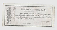
Description:
MINING CLAIM CERTIFICATE. MORRIS DISTRICT, K.T. Dated: March 25th 1861Clear Creek County, KANSAS TERRITORY (later and briefly, Jefferson Territory, and then, COLORADO TERRITORY)Imprint: DENVER MOUNTAINEER PRINTING ESTABLISHMENT. (Printer listed in Burt & Berthoud's ROCKY MOUNTAIN GOLD REGIONS, 1861, but was not long after bought out by William N. Byers' News Printing Company, Denver City, Jefferson Territory)Claim by Robert Lanilere for No. 5 West of the Elmira Lode. O. D. Montgomery, President of the Morris DistrictDimensions: 8-5/8 inches by 3-3/4 inchesCondition: very good plus to near fine; light folds most likely done in 1861; tiny chip to upper right-hand corner of certificate.Not listed in McMurtrie & Allen's EARLY PRINTING IN COLORADO, With a Bibliography of the Issues of the Press, 1859 to 1876,inclusive and a record and Bibliography of Colorado Territorial Newspapers. Hirschfeld Press, 1935Beyond exceedingly scarce Kansas - Colorado Territory imprint!!!COLORADO ARTIFACTUAL
Item Price
$2,500.00
$3.00
shipping to USA

Didn’t find what you’re looking for?
Try adding this search to your want list. Millions of books are added to our site everyday and when we find one that matches your search, we’ll send you an email. Best of all, it’s free.
Add to Want List

Are you a frequent reader or book collector?
Join the Bibliophile's Club and save 10% on every purchase, every day — up to $20 savings per order!

Social Responsibility
Did you know that since 2004, Biblio has used its profits to build 16 public libraries in rural villages of South America?