Description:
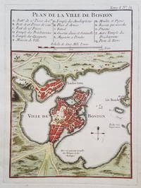
Classic Map of Boston from 1764A classic map of Boston and the immediately surrounding area published just after the French & Indian War. The map appeared in Bellin's Petit Atlas Maritime in 1764. A 16-item legend above the map identifies various public buildings, churches and fortifications.
Condition: Very good. Clear, dark impression with attractive hand color. Age toning at the edges. Wide margins. Crease in lower right margin outside of platemark.
[ICN 7512.3]


