Description:
Augsburg: Seutter, 1740. VG+, copperplate engraving with original hand coloring (color similar to Homann, with whom Seutter apprenticed before going out on his own in about 1707). There is minimal right marginal soling, but the image and color are exceptionally bright. Decorative cartouche, as usual, probably an allegorical representation of imperial Russia. The map measures 19.25x22.5 inches. .
Atlas of the Town of Hyde Park Norfolk County, Mass. From Official Plans and Actual Surveys by Anon - 1899
by Anon

Atlas of the Town of Hyde Park Norfolk County, Mass. From Official Plans and Actual Surveys
by Anon
- Used
- very good
- Hardcover
Boston: Geo. W. Stadly, 1899. Hardcover. Very Good. Large folio, 21" x 16 1/2". 12 maps of Hyde Park, all double page and colored. A few small marks and occasional thumb marks in the margins, but generally bright and quite attractive with no tears. Incorporated into the City of Boston in 1912 to become the southernmost neighborhood in the city, Hyde Park at this point was a separate city and the northernmost town in Norfolk County.
Brown cloth spine and corners over embossed cloth boards - heavily worn at corners, well through to the boards - binding shows relatively modest wear and rubbing otherwise. Binding tight, boards a little bowed.
At the time an industrial town situated at the confluence of the Neponset and the Mother Brook and connected to Boston by Hyde Park Avenue. It was home to the 54th Massachusetts Volunteer Infantry (the "Glory" division). Just one copy in OCLC at the Boston Public Library. Size: Elephant folio. Quantity Available: 1. Shipped Weight: 2-3 kilos. Category: Countries & Travel; Inventory No: 038090.
-
Bookseller
Pazzo Books
 (US)
(US)
- Format/Binding Hardcover
- Book Condition Used - Very Good
- Quantity Available 1
- Binding Hardcover
- Publisher Geo. W. Stadly
- Place of Publication Boston
- Date Published 1899
- Keywords Countries & Travel; NOISBN

(Map of Caspian Sea & Environs): Nova et Accuratissima Maris Caspii...petri Alexii Filii. Magni Russorum Emper
by Seutter, GM
- Used
- Condition
- Used
- Binding
- Unknown
- Quantity Available
- 1
- Seller
-
Crozet, Virginia, United States
- Item Price
-
$550.00
Show Details
Item Price
$550.00

More Photos
FL
by Wolff, Stephanie and Dorothy Simpson Krause.
- Used
- Signed
- Condition
- Used
- Edition
- Edition of 10 variants
- Binding
- Unknown
- Quantity Available
- 1
- Seller
-
Hoover, Alabama, United States
- Item Price
-
$800.00
Show Details
Description:
[Boca Raton, Florida]:: Jaffe Center for the Book Arts,, 2015.. Edition of 10 variants. 7.25 x 3.5"; 12 pages. Flutter book. Letterpress printed. Colophon with a map of Florida laser-printed. Cover and pages incorporate letterpress printing on a Vandercook 4 proof press using wood type, metal and collagraph plates. Blind printing of an area map. Printed on Arches 88 paper. Plant inclusion endpapers. Laid in handmade paper wrapper with slit-and-slot closure. Signed and numbered by the artists. Statement: "During Stephanie Wolff's residency at the Jaffe Center for Book Arts, she and Dorothy Krause, the first resident artist, collaborated on this brief ode to Florida. A variety of Pigment prints of vintage documents, maps, photographs and botanicals were transferred onto the pages of this edition of 10 variable copies.
Item Price
$800.00
![Penbrokshyre [Pembrokeshire],](https://d3525k1ryd2155.cloudfront.net/h/271/137/1078137271.0.m.jpg)
More Photos
Penbrokshyre [Pembrokeshire],
by John Speed
- Used
- Condition
- Used
- Quantity Available
- 1
- Seller
-
Plymouth, Devon, United Kingdom
- Item Price
-
$643.80
Show Details
Description:
Speed, John : Penbrokshyre described and the sittuations both of Penbroke and St Davids Shewed in due form as they were taken by John Speed. Sold by Bassett and Chiswell. Size approx 510mm x 380mm ( 20 x 15 inches). Early hand coloured double page copper engraved map. From Speed's "The Theatre of the Empire of Great Britain" with English text on verso with a description of the county and town listing. Inset town plans of Penbroke [Pembroke] and Saint Davids. Eleven coats of arms, scale and decorative title cartouche. Very small loss to lower blank margins not affecting printed area. An attractive Speed map in very good condition.
Item Price
$643.80

More Photos
Journal du voyage du chevalier Chardin en Perse et aux Indes orientales : par la mer Noire et par la Colchide : qui contient le voyage de Paris à Hispahan. Tome second.
by CHARDIN, John
- Used
- near fine
- Hardcover
- Condition
- Used - Near Fine
- Binding
- Hardcover
- Quantity Available
- 1
- Seller
-
COLUMBIA, Missouri, United States
- Item Price
-
$750.00
Show Details
Description:
1687 Travels of Chardin in PERSIA Middle East Iraq Turkey Iran Voyages FrenchA rare French edition of Jean Chardin's "Travels into Persia and the East Indies". This book is regarded as one of the finest works of early Western scholarship on Persia and the Near East. This printing was published at the same time as other French edition, all are considered first editions. In this book Chardin discusses his journeys from Constantinople to the Black Sea, Persia, and throughout the Middle East (Kashan, Iraq; Armenia, Crimea, and Georgia). The end of his journey took him through the Cape of Good Hope, on his way home.
Upon his return, he was considered quite a celebrity in London; though, according to Evelyn he was 'not inclined to talke wonders". He met with famous members of the Royal Society, all of whom took great interest in his voyage. He told them of his witnessing of Abbas II's coronation, and the jewels and fine ornaments he had seen.
This second volume from the 1687 French edition was… Read More
Item Price
$750.00

More Photos
Histoire des découvertes et des voyages faits dans le Nord
by FORSTER, Johann Reinhold
- Used
- near fine
- Hardcover
- first
- Condition
- Used - Near Fine
- Edition
- First
- Binding
- Hardcover
- Quantity Available
- 1
- Seller
-
COLUMBIA, Missouri, United States
- Item Price
-
$750.00
Show Details
Description:
1788 1st ed ARCTIC Voyages Johann Forster History of James Cook ATLAS Maps 2vJohann Reinhold Forster was an 18th-century Scottish naturalist who played an important role on James Cook's famous second Pacific voyage. Cook's second voyage was set to circumnavigate the world by means of going as far south as possible. This voyage, which is significantly less reported on than his third and final voyage, took Forster and crew to locations such as Easter Island, Tahiti, and the Arctic Circle. Perhaps the most important discovery from this voyage was proving that no continent existed between New Zealand and South America – a common theory amongst centuries of European navigators and historians.
Forster's 'History of Discoveries Made in the North' is one of the best accounts of voyages in the Arctic regions. He not only discusses his own experiences but covers expeditions made by Portuguese, English, French, and even Russian voyages into the Northwest Passage. He covers notable explorers such as Cabot,… Read More
Item Price
$750.00
More Photos
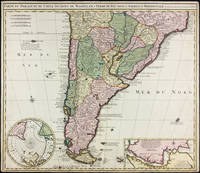
Carte du Paraguay, du Chili, Détroit de Magellan, & Terre de Feu, dans l'Amerique Meridionale par la veuve de Nicholas Visscher
by Visscher, Nicolas
- Used
- Condition
- Used - Margins trimmed but still quite ample, some small marginal stains, a handsome copy.
- Binding
- Unknown
- Quantity Available
- 1
- Seller
-
East Jewett, New York, United States
- Item Price
-
$750.00
Show Details
Description:
Amsterdam: Widow of Visscher, 1710. Single sheet copper engraved map, hand-colored. Margins trimmed but still quite ample, some small marginal stains, a handsome copy.. 515 x 595 mm. Strong image of the southern half of South America. Two insets: Carte particuliere de Detroit de Magellan and Circulus Antarcticus. Includes routes of the 18th c. explorers. Rodrigues 2556. Medina: Mapoteca Chilena, p.31, 10a (1740 ed).
Item Price
$750.00

More Photos
Rand, McNally & Co's Indexed County and Township Pocket Map and Shippers' Guide of New Jersey - Showing in Detail the Entire Railroad System, The Express Company Doing Business over Each Road, and Accurately Locating All Cities, Towns, Post Offices, Railr
by Rand McNally and Company
- Used
- Paperback
- first
- Condition
- Used - Very Good+ condition
- Edition
- 1st ed? (No additional printings listed)
- Binding
- Paperback
- Quantity Available
- 1
- Seller
-
Henderson, Nevada, United States
- Item Price
-
$695.00
Show Details
Description:
Chicago and New York: Rand McNally & Company, 1892. Very Good+ condition but for short tears at 3 or 4 of the map folds which have been neatly reinforced with archival tape on the blank side. SEE PHOTOS. A very attractive, well preserved copy. 60 pages of text, including brief information on 78 railroads, a detailed 39-page index, and ads for Rand McNally publications. Attached at the rear is a full color map (that unfolds to 13'' wide by 21" tall). Bound in the publisher's tan-color stiff printed wraps. Cover title: Rand, McNally & Co's Indexed County and Township Pocket Map and Shippers' Guide of New Jersey… Showing in Detail the Entire Railroad System, The Express Company Doing Business over Each Road, and Accurately Locating All Cities, Towns, Post Offices, Railroad Stations, Villages, Counties, Islands, Lakes, Rivers, etc… Locating… the Nearest Mailing Point of All Local Places; Designating… Telegraph Stations… Population is Given…
Read More Item Price
$695.00
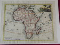
Carta Genererale dell' África.
by Delisle, Guillaume.
- Used
- Condition
- Used
- Quantity Available
- 1
- Seller
-
Florham Park, New Jersey, United States
- Item Price
-
$850.00
Show Details
Description:
Double-page hand colored engraved map, 350 x 445 mm (18" x 14", decorative cartouche. Coloring likely done at a later date, but attractively applied, wide margins, very minor aging; a bright and clear impression. Guillaume Delisle (1675-1726) was a French cartographer who was considered one of the best of his age. He has even been referred to as the father of modern geography, and was appointed Premier Geographer to Louis XV in 1718. According to Tooley and Bricker his 1700 map of Africa added a level of accuracy that would hold value for decades to come. This map of Africa is map number 84 in Norwich's Maps of Africa. The coloring was probably done at a later date, but there is an attractive cartouche with several figures, including a man spearing a crocodile. The map is from an Italian edition of Delisle’s Atlante Novissimo. Tooley & Bricker: Landmarks of Mapmaking. Norwich # 84.
Item Price
$850.00
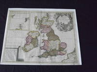
Les Isles Britanniques, qui Contiennent les Royaumes d' Angleterre, Escosse, et Irande…
by Valk, Gerard
- Used
- Condition
- Used
- Quantity Available
- 1
- Seller
-
Florham Park, New Jersey, United States
- Item Price
-
$600.00
Show Details
Description:
Copper engraved, double page, map, hand colored, cartouche uncolored, 49 x 59 cm (19 1/2" x 23"). Some minor soiling and aging; otherwise very good and quite colorful. Valk (1651-1726) was born in Amsterdam, and was also known as Valck. He was a fairly well known engraver and publisher, and would eventually go into partnership with Peter Schenk (1655-1718), and would produce an atlas and maps together. In fact, it seems they brought the property of the Blaeu firm, which gave them material for their maps. This is a very attractive map of Britain, and includes an inset of Orkney, Shetland and Faro islands. The map also contains a large cartouche that depicts angels and Poseidon. Bagrow p. 276.
Item Price
$600.00
More Photos
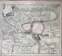
Kriegs-Expeditions-Karte in Bohmen I. Blat, in welchem die Haubtstadt Prag mit der Franzossischen und Saechsischen Belagerug und Eroberung, so den 26 Novembre 1941. / Carte des Expeditions de Guerre en Boheme, I Feuille dans laquette se voit le Plan de la Ville de Prague, assiegee et prise par les Troupes auxiliaires de France et de Saxe en l'An 1741, le 26. Novembre.
by Homann (Johann Baptist)
- Used
- Condition
- Used
- Binding
- Unknown
- Quantity Available
- 1
- Seller
-
Sidney, British Columbia, Canada
- Item Price
-
$550.00
Show Details
Description:
Nuremberg: Homann Erben (Homann Heirs), 1743. . A copper engraved map on laid paper, uncoloured decorative cartouche in upper left corner, inset maps in lower corners, text in German and French at top; text on map is in French. Map is partially coloured, inset maps coloured. Imprint at top: geschehen, vor gestellet wird. Ans Licht gestellt von Homoen Erben A1743 (and in French:) mise au jour par les Heritiers de Homan, l'An 1743. Verso blank. Plate measures 57cm x 51cm, on a sheet measuring 60cm x 54cm. Margins have been strengthened and slightly extended by pasting paper strips to the verso all the way around. Tear in upper margin, a couple of creases, tape repair on verso at top of fold, old stain to upper right corner; a clean very good copy. This map describes the 1741 Battle of Prague during the War of the Austrian Secession. The upper left cartouche prints a Legende, which contains an alphabetical key to locations and events, while the inset map at the lower right contains an alphabetical key…
Read More Item Price
$550.00

More Photos
The Sky and the Forest
by Forester, C.S
- Used
- Very Good
- Hardcover
- first
- Condition
- Used - Very Good
- Jacket Condition
- Very Good
- Edition
- First Edition
- Binding
- Hardcover
- Quantity Available
- 1
- Seller
-
Salem, Oregon, United States
- Item Price
-
$34.89$17.45Save $17.44!
Show Details
Description:
C.S. Forester: The Sky and the Forest. Little, Brown and Company, Boston. Stated First Edition First Printing Thus August, 1948. Cover price $2.75. Used. VG BOOK/VG UNCLIPPED DUST JACKET. A story of a central Africa. By C.S. Forester, author of the Admiral Hornblower series.
Item Price
$34.89$17.45
Save $17.44
!

More Photos
Plat Book: Pierce County, Wisconsin
by Rhame, A. E
- Used
- Fine
- Paperback
- Condition
- Used - Fine
- Binding
- Paperback
- Quantity Available
- 1
- Seller
-
Woodruff, Wisconsin, United States
- Item Price
-
$46.66
Show Details
Description:
1930. Soft Cover. Fine. Unpaginated. Tan colored book is in Fine condition, no sign of wear.
Item Price
$46.66
![Alaska and Klondike Region; [With inset of Klondike Region on the Upper Yukon detail] [From an...](https://d3525k1ryd2155.cloudfront.net/h/062/537/1339537062.0.m.jpg)
Alaska and Klondike Region; [With inset of Klondike Region on the Upper Yukon detail] [From an atlas, "Gazetteer of Alaska and Yukon Region " pp. 105 and 106]
by Miller, J. Martin
- Used
- Very Good
- Condition
- Used - Very Good
- Edition
- Unknown
- Quantity Available
- 1
- Seller
-
Sebastopol, California, United States
- Item Price
-
$39.00
Show Details
Description:
Chicago: J. Martin Miller, 1899. Unknown. Map. Very Good. [Map copyright 1899, printing date of Atlas later] [19.875x15.125in]; Colored map of Alaska with steamer routes from Portland and Seattle, insets of the Klondike Region on the Upper Yukon and Western portion of Aleutian Islands; On verso index of places and names with two large black and white images; Age toning to all edges, water stain marks on bottom, slight printing offset of colors, small chips and closed tears to lower edge;.
Item Price
$39.00

Last Tales
by Dinesen, Isak
- Used
- Very Good
- Hardcover
- first
- Condition
- Used - Very Good
- Jacket Condition
- Good+
- Edition
- First Edition
- Binding
- Hardcover
- Quantity Available
- 1
- Seller
-
Salem, Oregon, United States
- Item Price
-
$120.00$60.00Save $60.00!
Show Details
Description:
Dinesen, Isak: Last Tales, A Collection of Twelve New Tales of Compelling Beauty 1957, Random House. First Edition. Stated First Printing Thus. Used. Very Good/Good+ original red dust jacket, price-clipped. Jacket states 11/57 on front flap. 5 3/4 X
Item Price
$120.00$60.00
Save $60.00
!

Zemepis Sveta - Monsunova Asie
by De La Blache, P. Vidal; Gallois, L
- Used
- Hardcover
- Condition
- Used - Very Good Condition
- Jacket Condition
- No Dust Jacket
- Binding
- Hardcover
- Quantity Available
- 1
- Seller
-
Oak Point, Texas, United States
- Item Price
-
$60.00
Show Details
Description:
Aventinum, Prague, Czechoslovakia, 1931. Hardcover. Very Good Condition/No Dust Jacket. Text entirely in Czech. Geography book on Asia with numerous photographs and maps. 1930 edition also available. Size: 4mo - over 9 3/4" - 12" tall. 400 pp. Pages are yellowed, but are tight and clean. Moderate shelfwear along the spine. Corners are lightly bumped. Quantity Available: 1. Shipped Weight: 3-5 pounds. Category: Travel & Places; Non-English Language::Czech; Pictures of this item not already displayed here available upon request. Inventory No: 001228. . Additional shipping charges may apply.
Item Price
$60.00

Zemepis Sveta - Monsunova Asie
by De La Blache, P. Vidal; Gallois, L
- Used
- Hardcover
- Condition
- Used - Very Good Condition
- Jacket Condition
- No Dust Jacket
- Binding
- Hardcover
- Quantity Available
- 1
- Seller
-
Oak Point, Texas, United States
- Item Price
-
$60.00
Show Details
Description:
Aventinum, Prague, Czechoslovakia, 1930. Hardcover. Very Good Condition/No Dust Jacket. Text entirely in Czech. Geography book on Asia with numerous photographs and maps. 1931 edition also available. Size: 4mo - over 9 3/4" - 12" tall. 400 pp. Pages are yellowed, but are tight and clean. Moderate shelfwear along the spine. Corners are lightly bumped. Quantity Available: 1. Shipped Weight: 3-5 pounds. Category: Travel & Places; Non-English Language::Czech; Pictures of this item not already displayed here available upon request. Inventory No: 001227. . Additional shipping charges may apply.
Item Price
$60.00

The Adventure of Wrangel Island
by Vilhjalmur Stefansson
- Used
- Good
- Hardcover
- first
- Condition
- Used - Good
- Jacket Condition
- No DJ Included
- Edition
- First Edition
- Binding
- Hardcover
- Quantity Available
- 1
- Seller
-
Salem, Oregon, United States
- Item Price
-
$124.89$62.45Save $62.44!
Show Details
Description:
The Adventure of Wrangel Island, Alaska (1925 Macmillan 1st Edition) HISTORY OF ALASKA. EXLIB. Good Condition/ No DJ included. Fold-out map affixed to binding at the back of the book has never been opened. The story of the (unsuccessful) attempted colonization of Wrangel Island Alaska. 413 pages plus appendix, Index. Titling is still bright. A clean, solid copy. Scarce.
Item Price
$124.89$62.45
Save $62.44
!

Seven Pillars Of Wisdom, A Triumph
by Lawrence, T.E
- Used
- Good
- Hardcover
- first
- Condition
- Used - Good
- Jacket Condition
- No DJ Included
- Edition
- First American Edition
- Binding
- Hardcover
- Quantity Available
- 1
- Seller
-
Salem, Oregon, United States
- Item Price
-
$124.95$62.48Save $62.47!
Show Details
Description:
T.E. Lawrence. SEVEN PILLARS OF WISDOM, A TRIUMPH. AUTOBIOGRAPHY. Privately Printed, 1926. First Published for general circulation 1935. First American Edition. States MCMXXXVI on the title page. Doubleday, Doran & Company, Inc. Garden City, NY. GOOD CONDITION/ NO DUST JACKET IS INCLUDED. 672 pages, indexed. Beige buckram boards. Spine has darkened a bit. 6 7/8 X 9 ½.
Item Price
$124.95$62.48
Save $62.47
!

North America from the Best Authorities, Russell, ca.1800
by Russell
- Used
- Condition
- Used
- Quantity Available
- 1
- Seller
-
Plymouth, Devon, United Kingdom
- Item Price
-
$25.75
Show Details
Description:
Russell, J. : A General Map of North America from the Best Authorities. Nd but ca.1800. From "A New Geographical, Historical and Commercial Grammar and Present State of Several Kingdoms of the World." Copper engraving. Size approx 200 x 230mm. Two neat folds. Some age colouring to edges, otherwise very clean and bright.
Item Price
$25.75

Asia from the Best Authorities, Russell, ca.1800
by Russell
- Used
- Condition
- Used
- Quantity Available
- 1
- Seller
-
Plymouth, Devon, United Kingdom
- Item Price
-
$25.75
Show Details
Description:
Russell, J. : Asia from the Best Authorities. Nd but ca.1800. From "A New Geographical, Historical and Commercial Grammar and Present State of Several Kingdoms of the World". Copper engraving. Size approx 200 x 230mm. Two neat folds. Some age colouring to edges, otherwise clean and bright. Includes Arabia, India, Borneo, Japan, China and eastern Russia.
Item Price
$25.75