Description:
Nuremburg: J. B. Homann, 1730. Hand-coloured engraving. Good condition, margins re-backed to restore several minor losses and tears. A dramatic star chart by Doppelmayr illustrating the autumnal and early winter zodiacal signs: part of Libra, Scorpio, Sagittarius, and part of Capricorn. Johann Gabriel Doppelmayr (1677-1750) was a Nuremberg astronomer and mapmaker, who made globes, star charts, moon charts and completed Homann's Atlas Coelestis in 1742. This is part V of a group of six showing the entire panorama of the night sky as known and represented in the early 18th century. The stars are differentiated according to magnitude, and there is an extensive star index on each side of the chart. Johann Batiste Homann (1663-1724) began his professional life as an engraver for others, founding his own cartographical firm in 1702. He brought back to life German mapmaking, which virtually ceased in the early 16th century, using Dutch cartography as his guide and starting point.
Carey's General Atlas by CAREY, Mathew (1760-1839) - 1800
by CAREY, Mathew (1760-1839)
Similar copies are shown below.
Similar copies are shown to the right.

Carey's General Atlas
by CAREY, Mathew (1760-1839)
- Used
Philadelphia: Mathew Carey, 1800. Folio. (17 x 14 inches). 49 engraved maps, including 25 folding, and "A Map of Part of the N. W. Territory of the United States" with contemporary hand-coloring printed on heavy laid paper and dated 1796. 4 maps dated 1794, 2 dated 1795. With the title / table of contents page dated 1800, priced ten dollars, and with Philadelphia spelled "Ppiladelphia" Bound to style in half calf over contemporary speckled paper-covered boards, the flat spine divided into six compartments by double gilt fillets, red morocco lettering-piece in the second compartment with gilt title
An exceedingly rare edition of Carey's important and early General Atlas, here with remaindered US state maps dating to 1794 and 1795.
Carey, one of the most important publishers in American history, first issued his American Atlas in 1795 with 21 maps. Carey's was the first atlas printed in America. His General Atlas followed in 1796 with 45 maps. Most of the present atlas is devoted to the Americas with 27 of the 49 maps being of the New World. Of the 27, the majority concern the United States and its territories, and incorporate the latest geographical knowledge available to what was to become one of the premier mapping firms in the United States. Two additional important maps, not included in the 1796 edition, are Map 46, "Seven Ranges of Townships . . . laid out by Congress," which shows a section of what is now Ohio to be sold off by the federal government, and Map 47, "Part of the North Western Territory" by Samuel Lewis, dated 1796, which shows what is now the Greater Midwest. Beyond maps of Asia, Africa, South America, numerous European states, and even the North Pole and the whole world, there are detailed maps of each state then in the Union, including Georgia, Vermont, New Hampshire, Maine, Massachusetts, Rhode Island, Connecticut, New York, New Jersey, Pennsylvania (after Reading Howell), Delaware, Maryland, Kentucky (after Elihu Barker), South Carolina, North Carolina, a Virginia map dated 1794, one of the first printed maps of Tennessee (spelled "Tennassee"), and a map of the Ohio Territory before its naming in 1802.
Phillips, Atlases 3535. Sabin 10858. Not in Rumsey.
-
Bookseller
Donald Heald Rare Books
 (US)
(US)
- Format/Binding Folio
- Book Condition Used
- Quantity Available 1
- Publisher Mathew Carey
- Place of Publication Philadelphia
- Date Published 1800
We have 2 copies available starting at $20.81.

More Photos
[A portion of the celestial hemisphere showing part of Libra, Scorpio, Sagittarious and part of Capricorn] Globi Coelestis in Tabulas Planas Redacti Pars V in qua Longitudines Stellarum fixarum ad anum Christi completum 1730 tam Arithmetice quam Geometrice exhibentur..
by DOPPELMAYR, Johann Gabriel (1677-1750)
- Used
- Condition
- Used
- Binding
- Unknown
- Quantity Available
- 1
- Seller
-
New York, New York, United States
- Item Price
-
$1,700.00
Show Details
Item Price
$1,700.00

More Photos
Map of Massachusetts proper compiled from Actual Surveys made by Order of the General Court, and under the inspection of agents of their appointment
by CARLETON, Osgood (fl.1792-1806)
- Used
- Condition
- Used
- Binding
- Unknown
- Quantity Available
- 1
- Seller
-
New York, New York, United States
- Item Price
-
$18,000.00
Show Details
Description:
[Boston: B. & J. Loring, 1801. Copper-engraved map, with original outline colour, folded and mounted on linen. Publisher's paper label to verso, in good condition apart from some slight browning. Modern cloth chemise, within a morocco-backed cloth slipcase. A very rare and highly important early map of Massachusetts. The revised and much improved first "official" edition of the most important early map of Massachusetts. In three key ways, this edition is a great improvement over Osgood Carleton's 1798 original which was rejected for official sanction by the government of the Commonwealth. Firstly, the coastline and coastal islands have been more correctly rendered, largely due to the incorporation of information from the charts of Joseph Des Barres. Secondly, roads and streams that had been left incomplete in the earlier map were extended. Thirdly, some of the clutter of the 1798 map, engraved by Carleton's partner, John Norman, was removed, and the map is more attractive and informative, with a…
Read More Item Price
$18,000.00

More Photos
A Large Draught of the North Part of China Shewing the Passages and the Chanells into the Harbour of Chusan
by THORNTON, John (1641-1708) & Samuel (fl.1703-39)
- Used
- Condition
- Used
- Binding
- Unknown
- Quantity Available
- 1
- Seller
-
New York, New York, United States
- Item Price
-
$1,200.00
Show Details
Description:
London: William Mount & Thomas Page, 1734. Copper-engraved sea chart, in excellent condition, apart from an expertly repaired centre fold, and mild creases where the map folded. A very fine sea chart of China's Zhejiang Province, from the celebrated Third Book of 'The English Pilot.' This elegant and large sea chart captures China's modern day Zhejiang province. Located on the East China sea, just below the Yangtze Delta, this region was of major interest to European traders during the eighteenth-century. It features the major port of Zhousan (Chusan), and was the location of the entrance of the Grand Canal of China. The canal, construction of which began in the 5th-century B.C., was then the oldest and longest man-made waterway in the world, which allowed barges to travel hundreds to Beijing. In 1671, the London cartographer John Seller (fl.1664-97) commenced work on The English Pilot, a work that intended to challenge Dutch hegemony in the sea atlas market. Intended to be published in four books…
Read More Item Price
$1,200.00

More Photos
Map of Clear Creek County, Colorado. Drawn and compiled by Theo. H. Lowe and F.F. Bruné, C.E., Idaho, Colorado, Ter
by LOWE, Theodore H. and Francis F. BRUNÉ
- Used
- Condition
- Used
- Binding
- Unknown
- Quantity Available
- 1
- Seller
-
New York, New York, United States
- Item Price
-
$29,500.00
Show Details
Description:
Louisville: Hart and Mapother Lithographers, 1866. Lithographed map on six sheets unjoined, period hand-colouring in outline, three inset views (two attributed to be after Alfred E. Mathews), within an ornamental border (backed onto linen at an early date, inked library stamp on verso). An incredible, large-scale wall map of Clear Creek County, Colorado published less than a decade after the discovery of gold in the mining district and at the very outset of the area's settlement: a significant Colorado cartographic and mining rarity. Clear Creek County, located approximately 30 miles west of Denver, was one of the original 17 counties of Colorado Territory created in 1861. Settlement in the region, however, began in 1859 during the Pike's Peak Gold Rush, when prospectors settled along Clear Creek hoping to strike it rich. The large scale of this breathtaking map, projected at two thousand feet to the inch, allows for incredible detail of the county to be shown in the earliest years of its existence.…
Read More Item Price
$29,500.00
![Penbrokshyre [Pembrokeshire],](https://d3525k1ryd2155.cloudfront.net/h/271/137/1078137271.0.m.jpg)
More Photos
Penbrokshyre [Pembrokeshire],
by John Speed
- Used
- Condition
- Used
- Quantity Available
- 1
- Seller
-
Plymouth, Devon, United Kingdom
- Item Price
-
$643.80
Show Details
Description:
Speed, John : Penbrokshyre described and the sittuations both of Penbroke and St Davids Shewed in due form as they were taken by John Speed. Sold by Bassett and Chiswell. Size approx 510mm x 380mm ( 20 x 15 inches). Early hand coloured double page copper engraved map. From Speed's "The Theatre of the Empire of Great Britain" with English text on verso with a description of the county and town listing. Inset town plans of Penbroke [Pembroke] and Saint Davids. Eleven coats of arms, scale and decorative title cartouche. Very small loss to lower blank margins not affecting printed area. An attractive Speed map in very good condition.
Item Price
$643.80
More Photos
[A portion of the celestial hemisphere showing part of Libra, Scorpio, Sagittarious and part of Capricorn] Globi Coelestis in Tabulas Planas Redacti Pars V in qua Longitudines Stellarum fixarum ad anum Christi completum 1730 tam Arithmetice quam Geometrice exhibentur..
by DOPPELMAYR, Johann Gabriel (1677-1750)
- Used
- Condition
- Used
- Binding
- Unknown
- Quantity Available
- 1
- Seller
-
New York, New York, United States
- Item Price
-
$1,700.00
Show Details
Description:
Nuremburg: J. B. Homann, 1730. Hand-coloured engraving. Good condition, margins re-backed to restore several minor losses and tears. A dramatic star chart by Doppelmayr illustrating the autumnal and early winter zodiacal signs: part of Libra, Scorpio, Sagittarius, and part of Capricorn. Johann Gabriel Doppelmayr (1677-1750) was a Nuremberg astronomer and mapmaker, who made globes, star charts, moon charts and completed Homann's Atlas Coelestis in 1742. This is part V of a group of six showing the entire panorama of the night sky as known and represented in the early 18th century. The stars are differentiated according to magnitude, and there is an extensive star index on each side of the chart. Johann Batiste Homann (1663-1724) began his professional life as an engraver for others, founding his own cartographical firm in 1702. He brought back to life German mapmaking, which virtually ceased in the early 16th century, using Dutch cartography as his guide and starting point.
Item Price
$1,700.00
More Photos
Map of Massachusetts proper compiled from Actual Surveys made by Order of the General Court, and under the inspection of agents of their appointment
by CARLETON, Osgood (fl.1792-1806)
- Used
- Condition
- Used
- Binding
- Unknown
- Quantity Available
- 1
- Seller
-
New York, New York, United States
- Item Price
-
$18,000.00
Show Details
Description:
[Boston: B. & J. Loring, 1801. Copper-engraved map, with original outline colour, folded and mounted on linen. Publisher's paper label to verso, in good condition apart from some slight browning. Modern cloth chemise, within a morocco-backed cloth slipcase. A very rare and highly important early map of Massachusetts. The revised and much improved first "official" edition of the most important early map of Massachusetts. In three key ways, this edition is a great improvement over Osgood Carleton's 1798 original which was rejected for official sanction by the government of the Commonwealth. Firstly, the coastline and coastal islands have been more correctly rendered, largely due to the incorporation of information from the charts of Joseph Des Barres. Secondly, roads and streams that had been left incomplete in the earlier map were extended. Thirdly, some of the clutter of the 1798 map, engraved by Carleton's partner, John Norman, was removed, and the map is more attractive and informative, with a…
Read More Item Price
$18,000.00
More Photos
A Large Draught of the North Part of China Shewing the Passages and the Chanells into the Harbour of Chusan
by THORNTON, John (1641-1708) & Samuel (fl.1703-39)
- Used
- Condition
- Used
- Binding
- Unknown
- Quantity Available
- 1
- Seller
-
New York, New York, United States
- Item Price
-
$1,200.00
Show Details
Description:
London: William Mount & Thomas Page, 1734. Copper-engraved sea chart, in excellent condition, apart from an expertly repaired centre fold, and mild creases where the map folded. A very fine sea chart of China's Zhejiang Province, from the celebrated Third Book of 'The English Pilot.' This elegant and large sea chart captures China's modern day Zhejiang province. Located on the East China sea, just below the Yangtze Delta, this region was of major interest to European traders during the eighteenth-century. It features the major port of Zhousan (Chusan), and was the location of the entrance of the Grand Canal of China. The canal, construction of which began in the 5th-century B.C., was then the oldest and longest man-made waterway in the world, which allowed barges to travel hundreds to Beijing. In 1671, the London cartographer John Seller (fl.1664-97) commenced work on The English Pilot, a work that intended to challenge Dutch hegemony in the sea atlas market. Intended to be published in four books…
Read More Item Price
$1,200.00
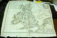
Nuova Carta dell' Isole Britanniche divise nei tre Regni d'Inghilterra, di Scozia, e d'Irlanda by [L'Isle (Guillaume de)]
by [L'Isle (Guillaume de)]
- Used
- Very Good
- Condition
- Used - Very Good
- Binding
- Unknown
- Quantity Available
- 1
- Seller
-
Binghamton, New York, United States
- Item Price
-
$205.00
Show Details
Description:
Albrizzi, 1743, Venice. Very Good. Prompt shipment, with tracking. we ship in CLEAN SECURE NEW boxes Full margins, uncolored, slight tearing to edges, folded with some repair to two folds. Very good. *
Item Price
$205.00
More Photos
Map of Clear Creek County, Colorado. Drawn and compiled by Theo. H. Lowe and F.F. Bruné, C.E., Idaho, Colorado, Ter
by LOWE, Theodore H. and Francis F. BRUNÉ
- Used
- Condition
- Used
- Binding
- Unknown
- Quantity Available
- 1
- Seller
-
New York, New York, United States
- Item Price
-
$29,500.00
Show Details
Description:
Louisville: Hart and Mapother Lithographers, 1866. Lithographed map on six sheets unjoined, period hand-colouring in outline, three inset views (two attributed to be after Alfred E. Mathews), within an ornamental border (backed onto linen at an early date, inked library stamp on verso). An incredible, large-scale wall map of Clear Creek County, Colorado published less than a decade after the discovery of gold in the mining district and at the very outset of the area's settlement: a significant Colorado cartographic and mining rarity. Clear Creek County, located approximately 30 miles west of Denver, was one of the original 17 counties of Colorado Territory created in 1861. Settlement in the region, however, began in 1859 during the Pike's Peak Gold Rush, when prospectors settled along Clear Creek hoping to strike it rich. The large scale of this breathtaking map, projected at two thousand feet to the inch, allows for incredible detail of the county to be shown in the earliest years of its existence.…
Read More Item Price
$29,500.00

Stock Photo: Cover May Be Different
The General Atlas for Carey's Edition of Guthrie's Geography Improved
by Mathew 1760-1839 Carey
- New
- Paperback
- Condition
- New
- Binding
- Paperback
- ISBN 10 / ISBN 13
- 9781014764881 / 1014764882
- Quantity Available
- 10
- Seller
-
Southport, Merseyside, United Kingdom
- Item Price
-
$20.81
Show Details
Description:
Paperback / softback. New.
Item Price
$20.81
Stock Photo: Cover May Be Different
The General Atlas for Carey's Edition of Guthrie's Geography Improved
by Carey, Mathew 1760-1839
- Used
- Good
- Paperback
- Condition
- Used - Good
- Binding
- Paperback
- ISBN 10 / ISBN 13
- 9781014764881 / 1014764882
- Quantity Available
- 1
- Seller
-
Newport Coast, California, United States
- Item Price
-
$49.51
Show Details
Description:
paperback. Good. Access codes and supplements are not guaranteed with used items. May be an ex-library book.
Item Price
$49.51

More Photos
The Sky and the Forest
by Forester, C.S
- Used
- Very Good
- Hardcover
- first
- Condition
- Used - Very Good
- Jacket Condition
- Very Good
- Edition
- First Edition
- Binding
- Hardcover
- Quantity Available
- 1
- Seller
-
Salem, Oregon, United States
- Item Price
-
$34.89$17.45Save $17.44!
Show Details
Description:
C.S. Forester: The Sky and the Forest. Little, Brown and Company, Boston. Stated First Edition First Printing Thus August, 1948. Cover price $2.75. Used. VG BOOK/VG UNCLIPPED DUST JACKET. A story of a central Africa. By C.S. Forester, author of the Admiral Hornblower series.
Item Price
$34.89$17.45
Save $17.44
!

More Photos
Plat Book: Pierce County, Wisconsin
by Rhame, A. E
- Used
- Fine
- Paperback
- Condition
- Used - Fine
- Binding
- Paperback
- Quantity Available
- 1
- Seller
-
Woodruff, Wisconsin, United States
- Item Price
-
$46.66
Show Details
Description:
1930. Soft Cover. Fine. Unpaginated. Tan colored book is in Fine condition, no sign of wear.
Item Price
$46.66
![Alaska and Klondike Region; [With inset of Klondike Region on the Upper Yukon detail] [From an...](https://d3525k1ryd2155.cloudfront.net/h/062/537/1339537062.0.m.jpg)
Alaska and Klondike Region; [With inset of Klondike Region on the Upper Yukon detail] [From an atlas, "Gazetteer of Alaska and Yukon Region " pp. 105 and 106]
by Miller, J. Martin
- Used
- Very Good
- Condition
- Used - Very Good
- Edition
- Unknown
- Quantity Available
- 1
- Seller
-
Sebastopol, California, United States
- Item Price
-
$39.00
Show Details
Description:
Chicago: J. Martin Miller, 1899. Unknown. Map. Very Good. [Map copyright 1899, printing date of Atlas later] [19.875x15.125in]; Colored map of Alaska with steamer routes from Portland and Seattle, insets of the Klondike Region on the Upper Yukon and Western portion of Aleutian Islands; On verso index of places and names with two large black and white images; Age toning to all edges, water stain marks on bottom, slight printing offset of colors, small chips and closed tears to lower edge;.
Item Price
$39.00

Zemepis Sveta - Monsunova Asie
by De La Blache, P. Vidal; Gallois, L
- Used
- Hardcover
- Condition
- Used - Very Good Condition
- Jacket Condition
- No Dust Jacket
- Binding
- Hardcover
- Quantity Available
- 1
- Seller
-
Oak Point, Texas, United States
- Item Price
-
$60.00
Show Details
Description:
Aventinum, Prague, Czechoslovakia, 1931. Hardcover. Very Good Condition/No Dust Jacket. Text entirely in Czech. Geography book on Asia with numerous photographs and maps. 1930 edition also available. Size: 4mo - over 9 3/4" - 12" tall. 400 pp. Pages are yellowed, but are tight and clean. Moderate shelfwear along the spine. Corners are lightly bumped. Quantity Available: 1. Shipped Weight: 3-5 pounds. Category: Travel & Places; Non-English Language::Czech; Pictures of this item not already displayed here available upon request. Inventory No: 001228. . Additional shipping charges may apply.
Item Price
$60.00

Last Tales
by Dinesen, Isak
- Used
- Very Good
- Hardcover
- first
- Condition
- Used - Very Good
- Jacket Condition
- Good+
- Edition
- First Edition
- Binding
- Hardcover
- Quantity Available
- 1
- Seller
-
Salem, Oregon, United States
- Item Price
-
$120.00$60.00Save $60.00!
Show Details
Description:
Dinesen, Isak: Last Tales, A Collection of Twelve New Tales of Compelling Beauty 1957, Random House. First Edition. Stated First Printing Thus. Used. Very Good/Good+ original red dust jacket, price-clipped. Jacket states 11/57 on front flap. 5 3/4 X
Item Price
$120.00$60.00
Save $60.00
!

Zemepis Sveta - Monsunova Asie
by De La Blache, P. Vidal; Gallois, L
- Used
- Hardcover
- Condition
- Used - Very Good Condition
- Jacket Condition
- No Dust Jacket
- Binding
- Hardcover
- Quantity Available
- 1
- Seller
-
Oak Point, Texas, United States
- Item Price
-
$60.00
Show Details
Description:
Aventinum, Prague, Czechoslovakia, 1930. Hardcover. Very Good Condition/No Dust Jacket. Text entirely in Czech. Geography book on Asia with numerous photographs and maps. 1931 edition also available. Size: 4mo - over 9 3/4" - 12" tall. 400 pp. Pages are yellowed, but are tight and clean. Moderate shelfwear along the spine. Corners are lightly bumped. Quantity Available: 1. Shipped Weight: 3-5 pounds. Category: Travel & Places; Non-English Language::Czech; Pictures of this item not already displayed here available upon request. Inventory No: 001227. . Additional shipping charges may apply.
Item Price
$60.00

The Adventure of Wrangel Island
by Vilhjalmur Stefansson
- Used
- Good
- Hardcover
- first
- Condition
- Used - Good
- Jacket Condition
- No DJ Included
- Edition
- First Edition
- Binding
- Hardcover
- Quantity Available
- 1
- Seller
-
Salem, Oregon, United States
- Item Price
-
$124.89$62.45Save $62.44!
Show Details
Description:
The Adventure of Wrangel Island, Alaska (1925 Macmillan 1st Edition) HISTORY OF ALASKA. EXLIB. Good Condition/ No DJ included. Fold-out map affixed to binding at the back of the book has never been opened. The story of the (unsuccessful) attempted colonization of Wrangel Island Alaska. 413 pages plus appendix, Index. Titling is still bright. A clean, solid copy. Scarce.
Item Price
$124.89$62.45
Save $62.44
!

Seven Pillars Of Wisdom, A Triumph
by Lawrence, T.E
- Used
- Good
- Hardcover
- first
- Condition
- Used - Good
- Jacket Condition
- No DJ Included
- Edition
- First American Edition
- Binding
- Hardcover
- Quantity Available
- 1
- Seller
-
Salem, Oregon, United States
- Item Price
-
$124.95$62.48Save $62.47!
Show Details
Description:
T.E. Lawrence. SEVEN PILLARS OF WISDOM, A TRIUMPH. AUTOBIOGRAPHY. Privately Printed, 1926. First Published for general circulation 1935. First American Edition. States MCMXXXVI on the title page. Doubleday, Doran & Company, Inc. Garden City, NY. GOOD CONDITION/ NO DUST JACKET IS INCLUDED. 672 pages, indexed. Beige buckram boards. Spine has darkened a bit. 6 7/8 X 9 ½.
Item Price
$124.95$62.48
Save $62.47
!

North America from the Best Authorities, Russell, ca.1800
by Russell
- Used
- Condition
- Used
- Quantity Available
- 1
- Seller
-
Plymouth, Devon, United Kingdom
- Item Price
-
$25.75
Show Details
Description:
Russell, J. : A General Map of North America from the Best Authorities. Nd but ca.1800. From "A New Geographical, Historical and Commercial Grammar and Present State of Several Kingdoms of the World." Copper engraving. Size approx 200 x 230mm. Two neat folds. Some age colouring to edges, otherwise very clean and bright.
Item Price
$25.75

Asia from the Best Authorities, Russell, ca.1800
by Russell
- Used
- Condition
- Used
- Quantity Available
- 1
- Seller
-
Plymouth, Devon, United Kingdom
- Item Price
-
$25.75
Show Details
Description:
Russell, J. : Asia from the Best Authorities. Nd but ca.1800. From "A New Geographical, Historical and Commercial Grammar and Present State of Several Kingdoms of the World". Copper engraving. Size approx 200 x 230mm. Two neat folds. Some age colouring to edges, otherwise clean and bright. Includes Arabia, India, Borneo, Japan, China and eastern Russia.
Item Price
$25.75