Description:
London: William Mount & Thomas Page, 1734. Copper-engraved sea chart, in excellent condition, apart from an expertly repaired centre fold, and mild creases where the map folded. A very fine sea chart of China's Zhejiang Province, from the celebrated Third Book of 'The English Pilot.' This elegant and large sea chart captures China's modern day Zhejiang province. Located on the East China sea, just below the Yangtze Delta, this region was of major interest to European traders during the eighteenth-century. It features the major port of Zhousan (Chusan), and was the location of the entrance of the Grand Canal of China. The canal, construction of which began in the 5th-century B.C., was then the oldest and longest man-made waterway in the world, which allowed barges to travel hundreds to Beijing. In 1671, the London cartographer John Seller (fl.1664-97) commenced work on The English Pilot, a work that intended to challenge Dutch hegemony in the sea atlas market. Intended to be published in four books…
Read More GEOGRAPHIA CLASSICA Geography of the Ancients 1723 by Herman Moll (See note) - 1723: Described as it is Contained in the Greek and Latin Classics in Twenty-nine Maps of the Old World
by Herman Moll (See note)

GEOGRAPHIA CLASSICA Geography of the Ancients 1723: Described as it is Contained in the Greek and Latin Classics in Twenty-nine Maps of the Old World
by Herman Moll (See note)
- Used
- Hardcover
London: Christopher Brown, 1723. Fourth edition. Original Papered board covers.Front cover detached (present). Back attached.. Light discolour all prelims,initials front pastedown, ffep. Few maps minor defects,Condition Good.. Title, Preface, Advert.,Table of Maps, Twenty-nine uncoloured, copper engraved maps laid down hand made paper. (Complete as called for title page) Overalll clean, minor faults (edges, marks, folds, couple with edge tide marks, etc) Above average. Maps: World (folding - includes part of northern Australia)), Trojan War, Ulysses, Voyage of Aeneas (2), 3 world maps single page, Roman Empire (infancy, Youthful, maturity, Julius Caesar) Hannibal, Gallia Vetus (incl part of GB), Baetica, Africa, Europe/Asia/Africa, Ancient Greece, Mediterranean (Lybia), Egypt, Pyrrhus, Demetrius, Sparta, Defeat 10,000 Greeks, Syria/Assyria, Scriptual Geography, Ecclesiastical History, Cyrus the Great, Persia, Alexander.
Rare cartographic publication. National Library Australia lists similar item by Herman Moll published 1749 , same Latin title containing 32 maps. Printed Bowles, London.
Please note: Due to International mail delivery problems, we currently ship items only to Australian addresses.
-
Bookseller
Independent bookstores
 (AU)
(AU)
- Format/Binding Original Papered board covers.Front cover detached (present). Back attached.
- Book Condition Used - Light discolour all prelims,initials front pastedown, ffep. Few maps minor defects,Condition Good
- Quantity Available 1
- Edition Fourth edition
- Binding Hardcover
- Publisher Christopher Brown
- Place of Publication London
- Date Published 1723
- Keywords Moll. Maps. Geographia Classica. Greek. Latin. Troy. Rome. Hannibal. Ulysses.Egypt. Syria. Cyrus. Alexander

More Photos
A Large Draught of the North Part of China Shewing the Passages and the Chanells into the Harbour of Chusan
by THORNTON, John (1641-1708) & Samuel (fl.1703-39)
- Used
- Condition
- Used
- Binding
- Unknown
- Quantity Available
- 1
- Seller
-
New York, New York, United States
- Item Price
-
$1,200.00
Show Details
Item Price
$1,200.00

CENT VUES SUISSES remarquables par leur Situation, ou par des Faits Historiques. Dessinn�es et grav�es par Hess, Hegui [sic], K�nig, Lory, Meyer, Wetzel etc.
by Orell, F�ssli (Publishers)
- Used
- very good
- Hardcover
- Condition
- Used - Very Good
- Binding
- Hardcover
- Quantity Available
- 1
- Seller
-
Blockley, Gloucestershire, United Kingdom
- Item Price
-
$963.02
Show Details
Description:
Zurich: Orell, F�ssli et Comp., 1825 approx). Hardcover. Very Good. Copperplate engravings (100) of Swiss views and domestic scenes by Hess, Hegui, K�nig, Lory, Meyer, Wetzel and others.. Oblong octavo green morocco elaborately gilt on 4 raised bands (lacks lowest spine compartment, tips & hinges worn but sound) All Edges Gilt. Titlepage +[3]pp publisher's list +[4]pp contents + 100 plate leaves printed one side only. Clean and crisp - lovely views with a few genre scenes - wedding, peasants defending land against invaders in 1798, making cheese etc. Minor foxing almost entirely to the margins or blank back of plates, small wormhole at foot of 3 leaves. *A charming work containing views by various artists here collected together for the first time (Lonchamp 3199).
Item Price
$963.02
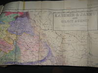
Survey of Pakistan Kashmir
- Used
- very good
- Paperback
- first
- Condition
- Used - Very Good
- Edition
- 1st Edition
- Binding
- Paperback
- Quantity Available
- 1
- Seller
-
Bath, Maine, United States
- Item Price
-
$980.00
Show Details
Description:
Jammer & Gilgit Agency, 1940 Government of Pakistan Full color Map 1 Inch = 16 miles. Extremely RARE OCLC locates 0 copies. 0 copies LOC. Oblong, no tears, or markings.. Oblong. 1st Edition. Soft cover. Very Good.
Item Price
$980.00
![A Geographicall [sic. Geographical ] Description Of All The Countries In The Known World. RARE...](https://d3525k1ryd2155.cloudfront.net/h/705/080/1090080705.0.m.jpg)
More Photos
A Geographicall [sic. Geographical ] Description Of All The Countries In The Known World. RARE 1657 geography
by Clarke, Samuel
- Used
- good
- Hardcover
- first
- Condition
- Used - Good
- Jacket Condition
- No Jacket
- Edition
- 1st Edition
- Binding
- Hardcover
- Quantity Available
- 1
- Seller
-
Portland, Oregon, United States
- Item Price
-
$850.00
Show Details
Description:
London: Thomas Newberry, 1657. 1st Edition . Hardcover. Good/No Jacket. 1657 FIRST EDITION, no illustrations, no maps, 278mm tall (covers), 272mm tall (pages). Full title: A Geographical Description Of All The Countries In The Known World. As Also Of the greatest and famousest Cities and Fabricks which have been, or are now remaining: Together with The greatest Rivers, the Strangest Fountains, the various Minerals, Stones, Trees, Hearbs, Plants, Fruits, Gums, &c. which are to bee found in every Country. Unto which is added, a Description of The rarest Beasts, Fowls, Birds, Fishes, and Serpents which are least known amongst us. Collected out of the most approved Authors, and from such as were eye-witnesses of most of the things contained herein. Vellum boards with calf title patch on spine lettered in gilt. Title page + 225 pages + 6 unnumbered pages of index + 7 pages of manuscript index. Soiled covers, some flaking on rear cover, solid binding, occasional page soiling but nothing major, wrinkle to…
Read More Item Price
$850.00

More Photos
ATLAS OF CATTARAUGUS COUNTY, NEW YORK : FROM ACTUAL SURVEYS AND OFFICIAL RECORDS
by D. G. Beers & Co , compiler
- Used
- very good
- Hardcover
- first
- Condition
- Used - Very Good
- Edition
- First Edition
- Binding
- Hardcover
- Quantity Available
- 1
- Seller
-
Fairfield, New Jersey, United States
- Item Price
-
$1,200.00
Show Details
Description:
New York: D. G. Beers & Co, A. D. Ellis & G. G. Soule. Very Good. 1869. First Edition. Hardcover. Original 1869 brown marbled boards over brown cloth spine. Contain 41 color maps including 4 that are double page. Each is appox. 12" 15". THE MAPS ARE IN VG TO NEAR FINE CONDITION. Occasional light soil on a margin. Atlas is graded G+ due to several tears along spine & rubbed cover edges & corners. Binding is tight. New York Atlas.. ; Folio 13" - 23" tall; 98 pages .
Item Price
$1,200.00
![The Countye Palatine of Chester with that most Ancient Citie described. [Cheshire], John Speed,...](https://d3525k1ryd2155.cloudfront.net/h/266/067/50067266.0.m.jpg)
More Photos
The Countye Palatine of Chester with that most Ancient Citie described. [Cheshire], John Speed, [1676]
by John Speed
- Used
- very good
- Condition
- Used - Very Good
- Edition
- Basset & Chiswell, [London, 1610-1676].
- Quantity Available
- 1
- Seller
-
Plymouth, Devon, United Kingdom
- Item Price
-
$947.85
Show Details
Description:
Speed, John : Cheshire. The Countye Palatine of Chester with that most Ancient Citie described. Basset & Chiswell, [London, 1610-1676]. Size approx 510mm x 380mm ( 20 x 15 inches). Early hand coloured double page copper engraved map. From Speed's "The Theatre of the Empire of Great Britain" with English text on verso and a description of the county and a gazetteer. Inset town plan of Chester. Seven coast of arms of "The Armes of the Earles of Chester since the Norman Conquest". Four decorative cartouches. Speed has used William Smith's revisions of Saxton and the Braun & Hogenberg plan of Chester. Good margins. Very small hole (approx 2mm or 1/10in) in the decorative border, otherwise fine condition. A strong dark impression of this famous decorative county map of Cheshire.
Item Price
$947.85

More Photos
Hudson River and the Hudson River Railroad: with a complete map and wood cut views of the principal objects of interest upon the line
by HUDSON RIVER RAILROAD
- Used
- Condition
- Used - Wrappers chipped at edges, professionally rebacked, some unobtrusive offsetting on map
- Binding
- Unknown
- Quantity Available
- 1
- Seller
-
Ardsley, New York, United States
- Item Price
-
$1,000.00
Show Details
Description:
New York: Wm. C. Locke & Co, 1851. Wrappers chipped at edges, professionally rebacked, some unobtrusive offsetting on map. 8vo. 50 pages. Large folding map on three joined sheets (21 x 1788 cm; 8.25 x 61.75 inches). 11 woodblock illustrations in text (and with 2 more not recorded in the index but always present). Original printed wrappers with woodblock vignette. SCARCE Hudson River Railroad travel guide published the first year in which the full line was completed. It covers points of interest along the route, with woodblocks illustrating the text. Topics include: the history of the Hudson River, the history of the construction of the Hudson River Railroad, and the cities, towns and villages along the Hudson, from New York City all the way to Troy. Concerning the West Point Foundry at Cold Spring, the guide states: "the iron foundry [was] established here by Gouverneur Kemble. The works are situated about a mile west of the village, upon a small stream which tumbles rapidly down the mountains,…
Read More Item Price
$1,000.00

More Photos
Traité de la géographie moderne
by GIBRAT, Jean Baptiste
- Used
- near fine
- Hardcover
- Condition
- Used - Near Fine
- Binding
- Hardcover
- Quantity Available
- 1
- Seller
-
COLUMBIA, Missouri, United States
- Item Price
-
$750.00
Show Details
Description:
1789 Atlas MAPS Gibrat Geography USA Italy Turkey Louisiana Mexico AmericaA rare 18th-century geographical treatise by Jean Baptiste Gibrat. Little is known of Gibrat other than this work; however, this work is a fine study in geography. Per the title, this work was designed for use of college and university students and includes descriptions of France, Switzerland, Greece, Turkey, Spain, Italy, and even America and Mexico!
Item number: #14739
Price: $750
GIBRAT, Jean Baptiste
Traité de la géographie moderne
A Toulouse, J. Robert ainé, 1789.
Details:
· Collation: Complete with all pages
o
xlviii, 412 (i.e. 456)
o 19 engraved plates
· Language: French
· Binding: Leather; tight & secure
· Size: ~6.75in X 4in (17cm x 10cm)
Our Guarantee:
Very Fast. Very Safe. Free Shipping Worldwide.
Customer satisfaction is our priority! Notify us with 7 days of receiving, and we will offer a full refund without reservation!
14739Photos available upon request.
Item Price
$750.00

More Photos
Gall and Inglis’ School Atlas of Modern Geography
by Gall and Inglis
- Used
- near fine
- Hardcover
- Condition
- Used - Near Fine
- Binding
- Hardcover
- Quantity Available
- 1
- Seller
-
COLUMBIA, Missouri, United States
- Item Price
-
$750.00
Show Details
Description:
1861 RARE Gall Inglis ATLAS Geography China America Australia 31 COLOR MAPSGall and Inglis' "School Atlas of Modern Geography" is a civil war compilation of 31 royal quarto maps. This 1861 edition includes maps of Europe, England and Wales, Ireland, Scotland, North America, South America, Switzerland, Turkey, Hindostan, and much more!
Item number: #13467
Price: $750
Gall and Inglis
Gall and Inglis' School Atlas of Modern Geography
Edinburgh: Gall & Inglis, 1861.
Details:
·
Collation: Complete with all pages
o 31 color maps
· Language: English
· Binding: Hardcover; tight & secure
o
Cloth
· Size: ~12.5in X 9.75in (31.5cm x 25cm)
Our Guarantee:
Very Fast. Very Safe. Free Shipping Worldwide.
Customer satisfaction is our priority! Notify us with 7 days of receiving, and we will offer a full refund without reservation!
13467Photos available upon request.
Item Price
$750.00

More Photos
1753 George Anson World Voyage 3 HUGE MAPS Spain South America Sea Navigation
by ANSON, George
- Used
- near fine
- Hardcover
- Condition
- Used - Near Fine
- Binding
- Hardcover
- Quantity Available
- 1
- Seller
-
COLUMBIA, Missouri, United States
- Item Price
-
$950.00
Show Details
Description:
1753 George Anson World Voyage 3 HUGE MAPS Spain South America Sea Navigation George Anson was an 18th-century British Navy admiral who is noted for his important world voyage in which he circumnavigated the globe. This voyage, beginning in 1740, was initiated in order to disrupt Spain and their acquisitions from the Pacific – even though the squadron saw certain danger.
"Anson's voyage is remembered as a classic tale of endurance and leadership in the face of fearful disasters" (Rodger, 239)
He saw substantial victory by capturing Spanish ships carrying pieces of eight, silver, and other treasure; thus, allowing Anson to return home a very rich sailor. This voyage took Anson and company into South America and home by way of China – a true world voyage!
This 1753 edition contains the expected three folding maps – a truly rare and desirable printing!
Item number: #18211
Price: $950
ANSON, George
A voyage round the world: in the years MDCCXL, I, II, III, IV. by George Anson, Esq; commander in… Read More
Item Price
$950.00

Stock Photo: Cover May Be Different
A history of the English wars, in France, Spain, Portugal, Netherlands, Germany, &c. ... With a large map of the same countries, ... and an alphabetical table, explaining the whole; ..
by Herman Moll
- Used
- good
- Paperback
- Condition
- Used - Good
- Binding
- Paperback
- ISBN 10 / ISBN 13
- 9781170175859 / 1170175856
- Quantity Available
- 1
- Seller
-
HOUSTON, Texas, United States
- Item Price
-
$20.48
Show Details
Description:
Gale ECCO, Print Editions, 2010-06-02. Paperback. Good.
Item Price
$20.48

Stock Photo: Cover May Be Different
Thirty two new and accurate maps of the geography of the ancients, as contained in the Greek and Latin classicks. ..
by Herman Moll
- Used
- good
- Paperback
- Condition
- Used - Good
- Binding
- Paperback
- ISBN 10 / ISBN 13
- 9781140710103 / 1140710109
- Quantity Available
- 1
- Seller
-
HOUSTON, Texas, United States
- Item Price
-
$23.07
Show Details
Description:
Gale ECCO, Print Editions, 2010-05-27. Paperback. Good.
Item Price
$23.07

Stock Photo: Cover May Be Different
A set of fifty new and correct maps of the counties of England and Wales, &c. with the great roads and principal cross-roads, ... All, except two, composed and done by Herman Moll, geographer. ..
by Herman Moll
- Used
- Paperback
- Condition
- Used: Good
- Binding
- Paperback
- ISBN 10 / ISBN 13
- 9781170844236 / 1170844235
- Quantity Available
- 1
- Seller
-
HOUSTON, Texas, United States
- Item Price
-
$26.98
Show Details
Description:
Gale ECCO, Print Editions, 2010-06-10. Paperback. Used: Good.
Item Price
$26.98

Stock Photo: Cover May Be Different
A View of the Coasts, Countries and Islands Within the Limits of the South-Sea-Company: Containing an Account of the Discoveries, Settlements, ... Terra del Fuego ...: To Which Is Added An...
by Moll, Herman
- Used
- Condition
- UsedVeryGood
- ISBN 10 / ISBN 13
- 9781275616967 / 1275616968
- Quantity Available
- 1
- Seller
-
Philadelphia, Pennsylvania, United States
- Item Price
-
$28.33
Show Details
Description:
UsedVeryGood. signs of little wear on the cover.
Item Price
$28.33
Stock Photo: Cover May Be Different
A View of the Coasts, Countries and Islands Within the Limits of the South-Sea-Company: Containing an Account of the Discoveries, Settlements, ... Terra del Fuego ...: To Which Is Added An...
by Moll, Herman
- Used
- Condition
- UsedLikeNew
- ISBN 10 / ISBN 13
- 9781275616967 / 1275616968
- Quantity Available
- 1
- Seller
-
Philadelphia, Pennsylvania, United States
- Item Price
-
$28.62
Show Details
Description:
UsedLikeNew. Remainder mark
Item Price
$28.62
Stock Photo: Cover May Be Different
A View of the coasts, countries and islands within the limits of the South-Sea-Company: containing an account of the discoveries, settlements, ... Terra del Fuego ... : to which is added an..
by Moll, Herman
- Used
- good
- Paperback
- Condition
- Used - Good
- Binding
- Paperback
- ISBN 10 / ISBN 13
- 9781275616967 / 1275616968
- Quantity Available
- 1
- Seller
-
HOUSTON, Texas, United States
- Item Price
-
$31.55
Show Details
Description:
Gale, Sabin Americana, 2012-02-21. Paperback. Good.
Item Price
$31.55
Stock Photo: Cover May Be Different
A history of the English wars, in France, Spain, Portugal, Netherlands, Germany, &c. ... With a large map of the same countries, ... and an alphabetical table, explaining the whole; ..
by Moll, Herman
- New
- Paperback
- Condition
- New
- Binding
- Paperback
- ISBN 10 / ISBN 13
- 9781170175859 / 1170175856
- Quantity Available
- 5
- Seller
-
campbelltown, Florida, United States
- Item Price
-
$18.00
Show Details
Description:
Gale ECCO, Print Editions. paperback. New. 7x0x9. Brand New Book in Publishers original Sealing
Item Price
$18.00

Stock Photo: Cover May Be Different
Atlas Manuale: or, a New Sett of Maps of All Parts of the Earth, as Well Asia, Africa, and America, as Europe; Wherein Geography is Rectify'd, by Reforming the Old Maps According to the Modern Observations; and the Coasts of All the Countries Are...
by Herman D 1732 Moll
- New
- Paperback
- Condition
- New
- Binding
- Paperback
- ISBN 10 / ISBN 13
- 9781014812254 / 1014812259
- Quantity Available
- 10
- Seller
-
Southport, Merseyside, United Kingdom
- Item Price
-
$20.42
Show Details
Description:
Paperback / softback. New.
Item Price
$20.42

Stock Photo: Cover May Be Different
A view of the coasts, countrys & islands within the limits of the South-Sea Company. Illustrated with a general map,and particular draughts of the most important places. The second edition
by Herman Moll
- Used
- good
- Paperback
- Condition
- Used - Good
- Binding
- Paperback
- ISBN 10 / ISBN 13
- 9781170776858 / 117077685X
- Quantity Available
- 1
- Seller
-
HOUSTON, Texas, United States
- Item Price
-
$34.77
Show Details
Description:
Gale ECCO, Print Editions, 2010-10-20. Paperback. Good.
Item Price
$34.77

Stock Photo: Cover May Be Different
A View of the Coasts, Countries and Islands Within the Limits of the South-Sea-Company. Containing an Account of the Discoveries, Settlements, Progress and Present State; Together With the Bays, Ports, Harbours, Rivers, &c. The Various Winds And...
by Herman D 1732 Cn Moll
- New
- Paperback
- Condition
- New
- Binding
- Paperback
- ISBN 10 / ISBN 13
- 9781015195165 / 1015195164
- Quantity Available
- 10
- Seller
-
Southport, Merseyside, United Kingdom
- Item Price
-
$22.81
Show Details
Description:
Paperback / softback. New.
Item Price
$22.81

More Photos
The Sky and the Forest
by Forester, C.S
- Used
- very good
- Hardcover
- first
- Condition
- Used - Very Good
- Jacket Condition
- Very Good
- Edition
- First Edition
- Binding
- Hardcover
- Quantity Available
- 1
- Seller
-
Salem, Oregon, United States
- Item Price
-
$34.89$17.45Save $17.44!
Show Details
Description:
C.S. Forester: The Sky and the Forest. Little, Brown and Company, Boston. Stated First Edition First Printing Thus August, 1948. Cover price $2.75. Used. VG BOOK/VG UNCLIPPED DUST JACKET. A story of a central Africa. By C.S. Forester, author of the Admiral Hornblower series.
Item Price
$34.89$17.45
Save $17.44
!
![Alaska and Klondike Region; [With inset of Klondike Region on the Upper Yukon detail] [From an...](https://d3525k1ryd2155.cloudfront.net/h/062/537/1339537062.0.m.jpg)
Alaska and Klondike Region; [With inset of Klondike Region on the Upper Yukon detail] [From an atlas, "Gazetteer of Alaska and Yukon Region " pp. 105 and 106]
by Miller, J. Martin
- Used
- very good
- Condition
- Used - Very Good
- Edition
- Unknown
- Quantity Available
- 1
- Seller
-
Sebastopol, California, United States
- Item Price
-
$39.00
Show Details
Description:
Chicago: J. Martin Miller, 1899. Unknown. Map. Very Good. [Map copyright 1899, printing date of Atlas later] [19.875x15.125in]; Colored map of Alaska with steamer routes from Portland and Seattle, insets of the Klondike Region on the Upper Yukon and Western portion of Aleutian Islands; On verso index of places and names with two large black and white images; Age toning to all edges, water stain marks on bottom, slight printing offset of colors, small chips and closed tears to lower edge;.
Item Price
$39.00

Last Tales
by Dinesen, Isak
- Used
- very good
- Hardcover
- first
- Condition
- Used - Very Good
- Jacket Condition
- Good+
- Edition
- First Edition
- Binding
- Hardcover
- Quantity Available
- 1
- Seller
-
Salem, Oregon, United States
- Item Price
-
$120.00$60.00Save $60.00!
Show Details
Description:
Dinesen, Isak: Last Tales, A Collection of Twelve New Tales of Compelling Beauty 1957, Random House. First Edition. Stated First Printing Thus. Used. Very Good/Good+ original red dust jacket, price-clipped. Jacket states 11/57 on front flap. 5 3/4 X
Item Price
$120.00$60.00
Save $60.00
!

Zemepis Sveta - Monsunova Asie
by De La Blache, P. Vidal; Gallois, L
- Used
- Hardcover
- Condition
- Used - Very Good Condition
- Jacket Condition
- No Dust Jacket
- Binding
- Hardcover
- Quantity Available
- 1
- Seller
-
Oak Point, Texas, United States
- Item Price
-
$60.00
Show Details
Description:
Aventinum, Prague, Czechoslovakia, 1931. Hardcover. Very Good Condition/No Dust Jacket. Text entirely in Czech. Geography book on Asia with numerous photographs and maps. 1930 edition also available. Size: 4mo - over 9 3/4" - 12" tall. 400 pp. Pages are yellowed, but are tight and clean. Moderate shelfwear along the spine. Corners are lightly bumped. Quantity Available: 1. Shipped Weight: 3-5 pounds. Category: Travel & Places; Non-English Language::Czech; Pictures of this item not already displayed here available upon request. Inventory No: 001228. . Additional shipping charges may apply.
Item Price
$60.00

Zemepis Sveta - Monsunova Asie
by De La Blache, P. Vidal; Gallois, L
- Used
- Hardcover
- Condition
- Used - Very Good Condition
- Jacket Condition
- No Dust Jacket
- Binding
- Hardcover
- Quantity Available
- 1
- Seller
-
Oak Point, Texas, United States
- Item Price
-
$60.00
Show Details
Description:
Aventinum, Prague, Czechoslovakia, 1930. Hardcover. Very Good Condition/No Dust Jacket. Text entirely in Czech. Geography book on Asia with numerous photographs and maps. 1931 edition also available. Size: 4mo - over 9 3/4" - 12" tall. 400 pp. Pages are yellowed, but are tight and clean. Moderate shelfwear along the spine. Corners are lightly bumped. Quantity Available: 1. Shipped Weight: 3-5 pounds. Category: Travel & Places; Non-English Language::Czech; Pictures of this item not already displayed here available upon request. Inventory No: 001227. . Additional shipping charges may apply.
Item Price
$60.00

The Adventure of Wrangel Island
by Vilhjalmur Stefansson
- Used
- good
- Hardcover
- first
- Condition
- Used - Good
- Jacket Condition
- No DJ Included
- Edition
- First Edition
- Binding
- Hardcover
- Quantity Available
- 1
- Seller
-
Salem, Oregon, United States
- Item Price
-
$124.89$62.45Save $62.44!
Show Details
Description:
The Adventure of Wrangel Island, Alaska (1925 Macmillan 1st Edition) HISTORY OF ALASKA. EXLIB. Good Condition/ No DJ included. Fold-out map affixed to binding at the back of the book has never been opened. The story of the (unsuccessful) attempted colonization of Wrangel Island Alaska. 413 pages plus appendix, Index. Titling is still bright. A clean, solid copy. Scarce.
Item Price
$124.89$62.45
Save $62.44
!

Seven Pillars Of Wisdom, A Triumph
by Lawrence, T.E
- Used
- good
- Hardcover
- first
- Condition
- Used - Good
- Jacket Condition
- No DJ Included
- Edition
- First American Edition
- Binding
- Hardcover
- Quantity Available
- 1
- Seller
-
Salem, Oregon, United States
- Item Price
-
$124.95$62.48Save $62.47!
Show Details
Description:
T.E. Lawrence. SEVEN PILLARS OF WISDOM, A TRIUMPH. AUTOBIOGRAPHY. Privately Printed, 1926. First Published for general circulation 1935. First American Edition. States MCMXXXVI on the title page. Doubleday, Doran & Company, Inc. Garden City, NY. GOOD CONDITION/ NO DUST JACKET IS INCLUDED. 672 pages, indexed. Beige buckram boards. Spine has darkened a bit. 6 7/8 X 9 ½.
Item Price
$124.95$62.48
Save $62.47
!

North America from the Best Authorities, Russell, ca.1800
by Russell
- Used
- Condition
- Used
- Quantity Available
- 1
- Seller
-
Plymouth, Devon, United Kingdom
- Item Price
-
$25.28
Show Details
Description:
Russell, J. : A General Map of North America from the Best Authorities. Nd but ca.1800. From "A New Geographical, Historical and Commercial Grammar and Present State of Several Kingdoms of the World." Copper engraving. Size approx 200 x 230mm. Two neat folds. Some age colouring to edges, otherwise very clean and bright.
Item Price
$25.28

Asia from the Best Authorities, Russell, ca.1800
by Russell
- Used
- Condition
- Used
- Quantity Available
- 1
- Seller
-
Plymouth, Devon, United Kingdom
- Item Price
-
$25.28
Show Details
Description:
Russell, J. : Asia from the Best Authorities. Nd but ca.1800. From "A New Geographical, Historical and Commercial Grammar and Present State of Several Kingdoms of the World". Copper engraving. Size approx 200 x 230mm. Two neat folds. Some age colouring to edges, otherwise clean and bright. Includes Arabia, India, Borneo, Japan, China and eastern Russia.
Item Price
$25.28
![MAP OF UTAH [Territory]](https://d3525k1ryd2155.cloudfront.net/h/836/461/1485461836.0.m.jpg)
More Photos
MAP OF UTAH [Territory]
- Used
- Condition
- Used - Very Good-
- Edition
- Original
- Quantity Available
- 1
- Seller
-
Williamsburg, Virginia, United States
- Item Price
-
$65.00
Show Details
Description:
New York, Richmond, Chicago, & Toledo: H. H. Hardesty, 1885. Original color lithographed map printed by Rand, McNally & Company, Engravers and published in HARDESTY'S HISTORICAL AND GEOGRAPHICAL ENCYCLOPEDIA: SPECIAL VIRGINIA EDITION. 19 3/8 inches by 13 1/4 inches on a 21" X 14 1/2" sheet. The map depicts the Territory of Utah in its final form--large areas had been removed and ceded to Nevada, Colorado, Wyoming, and Nebraska since Utah became a U. S. Territory in 1850. The issue of polygamy prevented statehood until it was finally granted in 1896. This map features railroads and topography and uses color to set off counties from each other. Unlike most atlas maps of the period, this map identifies most small towns. The map is guaranteed to be moe than 135 years old. The map is in about very good condition: generally clean and bright, with slight toning of paper and one faint water stain near the center-left edge of the map.. Original. Single Sheet. Very Good-. Elephant…
Read More Item Price
$65.00