Description:
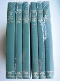
Storrs-Mansfield, CT / Parsippany, New Jersey: Martino Fine Books / About Books, 1995. 6 separate volumes, complete [5 volumes bound in 6 books WITH LARGE FOLD-OUT MAPS -- just like the first edition]. SEE PHOTOS. Each of the 6 books in this 1995 large format edition measures 9.25" wide by 12.25" tall. [This is NOT the later, smaller format 3-volume reprint in which the maps are reduced in size]. Unlike later reduced-size editions, the maps in this 1995 six-volume edition measure as large as 21" by 33" when unfolded. SEE PHOTOS. As original co-publisher, we are pleased to offer the few remaining sets of the 1995 large-format 6-volume edition (recently rediscovered in our warehouse). They are BRAND NEW in perfect condition. STILL SEALED in the publisher's clear plastic SHRINKWRAP and the PUBLISHER'S CARDBOARD SHIPPING BOX. NO rubbing. NO fading. Bright, clean, square and tight. NO owner's name or bookplate. NOT a remainder. Fresh and crisp -- obviously…
Read More Walker's Tour through England and Wales. A New Pastime. by Walker (linen-backed map game) - 1809
by Walker (linen-backed map game)

Walker's Tour through England and Wales. A New Pastime.
by Walker (linen-backed map game)
- Used
This is an original linen-backed folding map game published in London in 1809 by William Darton.
Overall 25 1/2 x 21 inches. It is an early example of the "Cartographic Game" genre that became very popular in later Victorian England. The map folds and fits into the original slipcase with printed label. The rules are printed in columns at the sides. The object of the game is to move tokens, originally in the shape of pyramids, their landing place determined by use of a teetotum (called a totum at that time) and read about the region upon which one landed. It was both competitive and educational.
Early map games such as this have become very scarce. Most did not survive since they were children’s toys. This one is in remarkably good condition. There is a light stain in the lower left of the map part and general light age-toning but the colors are bright and crisp. The linen backing is sound and the folds are intact. The original slipcase has two printed paper labels.
-
Bookseller
Independent bookstores
 (US)
(US)
- Book Condition Used
- Quantity Available 1
- Publisher Darton, William
- Place of Publication London
- Date Published 1809
- Keywords geographical game, map game
More Photos
Mapping the Transmississippi West [1995, 6 separate vols, complete; with large FOLD-OUT maps; new, in publisher's shrinkwrap & PUBLISHER'S CARDBOARD SHIPPING BOX
by Wheat, Carl I.
- New
- Hardcover
- first
- Condition
- New
- Jacket Condition
- in publisher's shrinkwrap
- Edition
- First Martino/About Books printing
- Binding
- Hardcover
- Quantity Available
- 1
- Seller
-
Henderson, Nevada, United States
- Item Price
-
$647.50
Show Details
Item Price
$647.50

More Photos
Méthode simple et facile pour lever les plans, suivie d'un traité du nivellement, d'un abrégé des règles du lavis et des élémens de trigonométrie rectiligne
by LECOY, François
- Used
- near fine
- Hardcover
- Condition
- Used - Near Fine
- Edition
- First
- Binding
- Hardcover
- Quantity Available
- 1
- Seller
-
COLUMBIA, Missouri, United States
- Item Price
-
$599.00
Show Details
Description:
1805 Surveying Method Topography COLOR Map Making Landscaping Construction LecoyFrancois Lecoy's 'Simple and Easy Methods for Surveying' is a fine, early 19th-century treatise on the systems used in construction and map preparation. Lecoy discusses the means by which French surveyors level land through the means of linear trigonometry. This 1805 first edition is an exception example of early 19th-century landscaping and topography. Note that this book includes impressive, folding color engravings of topographical examples and surveying tools.
Item number: #11652
Price: $599
LECOY, François
Méthode simple et facile pour lever les plans, suivie d'un traité du nivellement, d'un abrégé des règles du lavis et des élémens de trigonométrie rectiligne
A Paris : Chez Duponcet ..., an XIII=1805. First edition.
Details:
·
Collation: Complete with all pages
o xxxii, 119, [1], 12
o 12 folding plates
·
Provenance: Handwritten – Duponcet
o Signed by the publisher
·… Read More
Item Price
$599.00

More Photos
Gall and Inglis’ School Atlas of Modern Geography
by Gall and Inglis
- Used
- near fine
- Hardcover
- Condition
- Used - Near Fine
- Binding
- Hardcover
- Quantity Available
- 1
- Seller
-
COLUMBIA, Missouri, United States
- Item Price
-
$750.00
Show Details
Description:
1861 RARE Gall Inglis ATLAS Geography China America Australia 31 COLOR MAPSGall and Inglis' "School Atlas of Modern Geography" is a civil war compilation of 31 royal quarto maps. This 1861 edition includes maps of Europe, England and Wales, Ireland, Scotland, North America, South America, Switzerland, Turkey, Hindostan, and much more!
Item number: #13467
Price: $750
Gall and Inglis
Gall and Inglis' School Atlas of Modern Geography
Edinburgh: Gall & Inglis, 1861.
Details:
·
Collation: Complete with all pages
o 31 color maps
· Language: English
· Binding: Hardcover; tight & secure
o
Cloth
· Size: ~12.5in X 9.75in (31.5cm x 25cm)
Our Guarantee:
Very Fast. Very Safe. Free Shipping Worldwide.
Customer satisfaction is our priority! Notify us with 7 days of receiving, and we will offer a full refund without reservation!
13467Photos available upon request.
Item Price
$750.00

More Photos
A star atlas for the library, the school, and the observatory showing 6,000 stars and 1,500 objects of interest
by PROCTOR, Richard A
- Used
- near fine
- Hardcover
- Condition
- Used - Near Fine
- Binding
- Hardcover
- Quantity Available
- 1
- Seller
-
COLUMBIA, Missouri, United States
- Item Price
-
$599.00
Show Details
Description:
1874 Astronomy Star ATLAS Zodiac Constellation MAPS Richard Proctor AstrologyRichard Proctor was a 19th-century English astronomer known for his studies on the planets in the solar system as well as the moon and the sun. In his many astronomical books, Proctor discusses his research on the planets, stars and constellations, and the sun, as well as his observations on meteors and comets. His most fascinating work was 'A Star Atlas' – an impressive collection of star and constellation charts and night sky maps.
Item number: #19450
Price: $599
PROCTOR, Richard A
A star atlas for the library, the school, and the observatory showing 6,000 stars and 1,500 objects of interest
London : Longmans, Green, 1874.
Details:
· Collation: Complete with all pages
o
14, [2]
o
14 double-page charts
· Language: English
· Binding: Hardcover; tight and secure
o
Cloth
· Size: ~14.75in X 9.75in (37.5cm x 25cm)
· Quite scarce
Our Guarantee:
Very Fast. Very Safe. Free Shipping… Read More
Item Price
$599.00

More Photos
A new system of modern geography : or, a geographical historical, and commercial grammar; and present state of the several kingdoms of the world. ... By William Guthrie, Esq. The astronomical part by James Ferguson, F.R.S. To which have been added, the late discoveries of Dr. Herschell
by GUTHRIE, William
- Used
- near fine
- Hardcover
- Condition
- Used - Near Fine
- Binding
- Hardcover
- Quantity Available
- 1
- Seller
-
COLUMBIA, Missouri, United States
- Item Price
-
$750.00
Show Details
Description:
1792 Guthrie ATLAS & Geography 21 MAPS Illustrated Navigation America Asia IndiaWilliam Guthrie was well known during the mid-18th-century for his many contributions to world history, especially through his extensive and thorough books. As a Scottish historian, he published one of the world's best and most popular geography texts of the 18th-century.
This truly impressive 1792 single-volume edition is illustrated with 21 maps! Other interesting inclusions of note:
·
Chronological table/list of world events
·
An illustration of an armillary sphere
·
Coin equivalency tables
·
An early, important description of the discovery of America – though, according to Evans, much of Guthrie's section on America is attributed to Jedidiah Morse (Evans 27077, 28782). Sabin even notes that this work includes "much matter relating to America").
Item number: #21076
Price: $750
GUTHRIE, William
A new system of modern geography : or, a geographical historical, and commercial grammar;… Read More
Item Price
$750.00

(Map of Caspian Sea & Environs): Nova et Accuratissima Maris Caspii...petri Alexii Filii. Magni Russorum Emper
by Seutter, GM
- Used
- Condition
- Used
- Binding
- Unknown
- Quantity Available
- 1
- Seller
-
Crozet, Virginia, United States
- Item Price
-
$550.00
Show Details
Description:
Augsburg: Seutter, 1740. VG+, copperplate engraving with original hand coloring (color similar to Homann, with whom Seutter apprenticed before going out on his own in about 1707). There is minimal right marginal soling, but the image and color are exceptionally bright. Decorative cartouche, as usual, probably an allegorical representation of imperial Russia. The map measures 19.25x22.5 inches. .
Item Price
$550.00

More Photos
Cartes Larousse: Atlas de la Guerre. With Directions in English, I-XLI [41 ISSUES WITH 206 PLATES. COMPLETE].
by (Cartes Larousse).
- Used
- Hardcover
- first
- Condition
- Used - .
- Edition
- 1st Edition
- Binding
- Hardcover
- Quantity Available
- 1
- Seller
-
, Netherlands
- Item Price
-
$652.08
Show Details
Description:
Paris, Librairie Larousse, (1915-19).. 1st Edition . Hardcover. .. 41 issues bound in one volume. Thick royal quarto. Unpaginated. With hundreds of letterpress maps, many of which are in colour, printed on recto only on 246 leaves of plates. Some photo-plates. Explanatory text to each map. Introductions. HARDCOVER, bound in contemporary quarter cloth, bit rubbed and scuffed in places, paper-covered boards, cloth inner hinges, spine gilt. All 41 original yellow card wrappers, printed in red, are preserved and bound-in, few with old institutional stamp; expert paper repair to one leaf with minor loss. In about fine condition. Excellent copy, very well preserved. ~ FIRST EDITION. Very rare. F-3
Item Price
$652.08

More Photos
FL
by Wolff, Stephanie and Dorothy Simpson Krause.
- Used
- Signed
- Condition
- Used
- Edition
- Edition of 10 variants
- Binding
- Unknown
- Quantity Available
- 1
- Seller
-
Hoover, Alabama, United States
- Item Price
-
$800.00
Show Details
Description:
[Boca Raton, Florida]:: Jaffe Center for the Book Arts,, 2015.. Edition of 10 variants. 7.25 x 3.5"; 12 pages. Flutter book. Letterpress printed. Colophon with a map of Florida laser-printed. Cover and pages incorporate letterpress printing on a Vandercook 4 proof press using wood type, metal and collagraph plates. Blind printing of an area map. Printed on Arches 88 paper. Plant inclusion endpapers. Laid in handmade paper wrapper with slit-and-slot closure. Signed and numbered by the artists. Statement: "During Stephanie Wolff's residency at the Jaffe Center for Book Arts, she and Dorothy Krause, the first resident artist, collaborated on this brief ode to Florida. A variety of Pigment prints of vintage documents, maps, photographs and botanicals were transferred onto the pages of this edition of 10 variable copies.
Item Price
$800.00
![Penbrokshyre [Pembrokeshire],](https://d3525k1ryd2155.cloudfront.net/h/271/137/1078137271.0.m.jpg)
More Photos
Penbrokshyre [Pembrokeshire],
by John Speed
- Used
- Condition
- Used
- Quantity Available
- 1
- Seller
-
Plymouth, Devon, United Kingdom
- Item Price
-
$631.90
Show Details
Description:
Speed, John : Penbrokshyre described and the sittuations both of Penbroke and St Davids Shewed in due form as they were taken by John Speed. Sold by Bassett and Chiswell. Size approx 510mm x 380mm ( 20 x 15 inches). Early hand coloured double page copper engraved map. From Speed's "The Theatre of the Empire of Great Britain" with English text on verso with a description of the county and town listing. Inset town plans of Penbroke [Pembroke] and Saint Davids. Eleven coats of arms, scale and decorative title cartouche. Very small loss to lower blank margins not affecting printed area. An attractive Speed map in very good condition.
Item Price
$631.90
More Photos
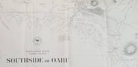
Southside of Oahu.
by [Hawaii: Oahu.] U.S. Navy.
- Used
- Condition
- Used
- Quantity Available
- 1
- Seller
-
Scarborough, Maine, United States
- Item Price
-
$750.00
Show Details
Description:
Scarce Chart of Oahu: Pearl Harbor to Diamond HeadThis is a wonderfully detailed chart of the Pearl Harbor/Honolulu area. It names Diamond Head, Waikiki, Honolulu (with street grid shown), and Pearl Lochs (later, Pearl Harbor) and locates numerous landmarks: school, windmill, leper asylum, prison and several areas with heavy surf and breakers.
The chart appears to be directly derived from a larger, separately issued chart of the same title that covered a somewhat larger area (Hydrographic Office Chart no. 867). The larger chart was first issued in 1880 and updated at least through 1901. While a very short segment of Oahu R.R. is shown just west of Honolulu on the present chart, the much longer stretch of the railway that looped around the northern portion of Pearl Lochs is not shown here as it is on the 1899 edition of the larger map. Since the main portion of the Oahu Railway was completed in late 1889, it suggests that the present map was completed prior to that date. We have been unable to… Read More
Item Price
$750.00

Stock Photo: Cover May Be Different
Biblical Counseling With African-Americans: Taking a Ride in the Ethiopian's Chariot
by Walker, Clarence
- Used
- Condition
- UsedVeryGood
- ISBN 10 / ISBN 13
- 9780310587118 / 0310587115
- Quantity Available
- 1
- Seller
-
RALEIGH, North Carolina, United States
- Item Price
-
$2.82
Show Details
Description:
UsedVeryGood. Clean, great binding. Cover shows light wear from reading/handling. Dog-Eared Books is a small, women owned and operated business.
Item Price
$2.82

Stock Photo: Cover May Be Different
Make Room for Joy: Choose Hope, Discover Purpose and Cultivate Joy in the Middle of Life's Most Complicated Seasons
by Walker, Vanessa Joy
- Used
- Condition
- UsedGood
- ISBN 10 / ISBN 13
- 9781952025013 / 195202501X
- Quantity Available
- 1
- Seller
-
RALEIGH, North Carolina, United States
- Item Price
-
$2.82
Show Details
Description:
UsedGood. Clean, great binding. Cover shows light wear from reading/handling. Dog-Eared Books is a small, women owned and operated business.
Item Price
$2.82

Stock Photo: Cover May Be Different
God, Dr. Buzzard, and the Bolito Man: A Saltwater Geechee Talks About Life on Sapelo Island, Georgia
by Bailey, Cornelia Walker
- Used
- Condition
- UsedGood
- ISBN 10 / ISBN 13
- 9780385493772 / 0385493770
- Quantity Available
- 1
- Seller
-
RALEIGH, North Carolina, United States
- Item Price
-
$2.82
Show Details
Description:
UsedGood. Clean, great binding. Cover shows light wear from reading/handling. Dog-Eared Books is a small, women owned and operated business.
Item Price
$2.82

Stock Photo: Cover May Be Different
Better Davis and Other Stories
by Walker, Philip Dean
- Used
- Condition
- UsedVeryGood
- ISBN 10 / ISBN 13
- 9781941960158 / 1941960154
- Quantity Available
- 1
- Seller
-
RALEIGH, North Carolina, United States
- Item Price
-
$2.82
Show Details
Description:
UsedVeryGood. Clean, great binding. Cover shows light wear from reading/handling. Dog-Eared Books is a small, women owned and operated business.
Item Price
$2.82

Stock Photo: Cover May Be Different
Biotechnology Demystified
by Walker, Sharon
- Used
- Condition
- UsedGood
- ISBN 10 / ISBN 13
- 9780071448123 / 0071448128
- Quantity Available
- 1
- Seller
-
RALEIGH, North Carolina, United States
- Item Price
-
$3.61
Show Details
Description:
UsedGood. Clean, great binding. Cover shows light wear from reading/handling. Dog-Eared Books is a small, women owned and operated business. Light highlighting in book.
Item Price
$3.61

Stock Photo: Cover May Be Different
Crime Scene Investigations: Real-Life Science Activities for the Elementary Grades
by Walker, Pam
- Used
- Condition
- UsedVeryGood
- ISBN 10 / ISBN 13
- 9780130842503 / 0130842508
- Quantity Available
- 1
- Seller
-
RALEIGH, North Carolina, United States
- Item Price
-
$3.61
Show Details
Description:
UsedVeryGood. Pages are clean. Clean, great binding. Cover shows light wear from reading/handling. Dog-Eared Books is a small, women owned and operated business.
Item Price
$3.61

Stock Photo: Cover May Be Different
Free Willy
by Krulik, Nancy E., Walker, Keith A., Blechman, Corey
- Used
- Acceptable
- Condition
- Used - Acceptable
- Edition
- Media Tie In
- ISBN 10 / ISBN 13
- 9780590467575 / 0590467573
- Quantity Available
- 1
- Seller
-
Philadelphia, Pennsylvania, United States
- Item Price
-
$3.66
Show Details
Description:
Scholastic. Media Tie In. Acceptable. Acceptable. Ship within 24hrs. Satisfaction 100% guaranteed. APO/FPO addresses supported
Item Price
$3.66

Stock Photo: Cover May Be Different
Let's Talk About Masks: A Children's Book and Conversation Starter for Parents
by Walker, Sara Jo
- Used
- Acceptable
- Condition
- Used - Acceptable
- Edition
- Illustrated
- ISBN 10 / ISBN 13
- 9781949758733 / 1949758737
- Quantity Available
- 1
- Seller
-
Philadelphia, Pennsylvania, United States
- Item Price
-
$3.70
Show Details
Description:
Emerge Publishing Group, LLC. Illustrated. Acceptable. Acceptable. Heavy wear. Ship within 24hrs. Satisfaction 100% guaranteed. APO/FPO addresses supported
Item Price
$3.70

Stock Photo: Cover May Be Different
The Very First Case (10) (Rider Woofson)
by Styles, Walker
- Used
- Acceptable
- Condition
- Used - Acceptable
- Edition
- Illustrated
- ISBN 10 / ISBN 13
- 9781534412712 / 1534412719
- Quantity Available
- 1
- Seller
-
Philadelphia, Pennsylvania, United States
- Item Price
-
$3.70
Show Details
Description:
Little Simon. Illustrated. Acceptable. Acceptable. Ship within 24hrs. Satisfaction 100% guaranteed. APO/FPO addresses supported
Item Price
$3.70
Stock Photo: Cover May Be Different
Let's Talk About Masks: A Children's Book and Conversation Starter for Parents
by Walker, Sara Jo
- Used
- very good
- Condition
- Used - Very Good
- Edition
- Illustrated
- ISBN 10 / ISBN 13
- 9781949758733 / 1949758737
- Quantity Available
- 1
- Seller
-
Philadelphia, Pennsylvania, United States
- Item Price
-
$3.70
Show Details
Description:
Emerge Publishing Group, LLC. Illustrated. Very Good. Very Good. Ship within 24hrs. Satisfaction 100% guaranteed. APO/FPO addresses supported
Item Price
$3.70

More Photos
The Sky and the Forest
by Forester, C.S
- Used
- very good
- Hardcover
- first
- Condition
- Used - Very Good
- Jacket Condition
- Very Good
- Edition
- First Edition
- Binding
- Hardcover
- Quantity Available
- 1
- Seller
-
Salem, Oregon, United States
- Item Price
-
$34.89$17.45Save $17.44!
Show Details
Description:
C.S. Forester: The Sky and the Forest. Little, Brown and Company, Boston. Stated First Edition First Printing Thus August, 1948. Cover price $2.75. Used. VG BOOK/VG UNCLIPPED DUST JACKET. A story of a central Africa. By C.S. Forester, author of the Admiral Hornblower series.
Item Price
$34.89$17.45
Save $17.44
!

More Photos
Plat Book: Pierce County, Wisconsin
by Rhame, A. E
- Used
- Fine
- Paperback
- Condition
- Used - Fine
- Binding
- Paperback
- Quantity Available
- 1
- Seller
-
Woodruff, Wisconsin, United States
- Item Price
-
$46.66
Show Details
Description:
1930. Soft Cover. Fine. Unpaginated. Tan colored book is in Fine condition, no sign of wear.
Item Price
$46.66
![Alaska and Klondike Region; [With inset of Klondike Region on the Upper Yukon detail] [From an...](https://d3525k1ryd2155.cloudfront.net/h/062/537/1339537062.0.m.jpg)
Alaska and Klondike Region; [With inset of Klondike Region on the Upper Yukon detail] [From an atlas, "Gazetteer of Alaska and Yukon Region " pp. 105 and 106]
by Miller, J. Martin
- Used
- very good
- Condition
- Used - Very Good
- Edition
- Unknown
- Quantity Available
- 1
- Seller
-
Sebastopol, California, United States
- Item Price
-
$39.00
Show Details
Description:
Chicago: J. Martin Miller, 1899. Unknown. Map. Very Good. [Map copyright 1899, printing date of Atlas later] [19.875x15.125in]; Colored map of Alaska with steamer routes from Portland and Seattle, insets of the Klondike Region on the Upper Yukon and Western portion of Aleutian Islands; On verso index of places and names with two large black and white images; Age toning to all edges, water stain marks on bottom, slight printing offset of colors, small chips and closed tears to lower edge;.
Item Price
$39.00

Zemepis Sveta - Monsunova Asie
by De La Blache, P. Vidal; Gallois, L
- Used
- Hardcover
- Condition
- Used - Very Good Condition
- Jacket Condition
- No Dust Jacket
- Binding
- Hardcover
- Quantity Available
- 1
- Seller
-
Oak Point, Texas, United States
- Item Price
-
$60.00
Show Details
Description:
Aventinum, Prague, Czechoslovakia, 1931. Hardcover. Very Good Condition/No Dust Jacket. Text entirely in Czech. Geography book on Asia with numerous photographs and maps. 1930 edition also available. Size: 4mo - over 9 3/4" - 12" tall. 400 pp. Pages are yellowed, but are tight and clean. Moderate shelfwear along the spine. Corners are lightly bumped. Quantity Available: 1. Shipped Weight: 3-5 pounds. Category: Travel & Places; Non-English Language::Czech; Pictures of this item not already displayed here available upon request. Inventory No: 001228. . Additional shipping charges may apply.
Item Price
$60.00

Last Tales
by Dinesen, Isak
- Used
- very good
- Hardcover
- first
- Condition
- Used - Very Good
- Jacket Condition
- Good+
- Edition
- First Edition
- Binding
- Hardcover
- Quantity Available
- 1
- Seller
-
Salem, Oregon, United States
- Item Price
-
$120.00$60.00Save $60.00!
Show Details
Description:
Dinesen, Isak: Last Tales, A Collection of Twelve New Tales of Compelling Beauty 1957, Random House. First Edition. Stated First Printing Thus. Used. Very Good/Good+ original red dust jacket, price-clipped. Jacket states 11/57 on front flap. 5 3/4 X
Item Price
$120.00$60.00
Save $60.00
!

Zemepis Sveta - Monsunova Asie
by De La Blache, P. Vidal; Gallois, L
- Used
- Hardcover
- Condition
- Used - Very Good Condition
- Jacket Condition
- No Dust Jacket
- Binding
- Hardcover
- Quantity Available
- 1
- Seller
-
Oak Point, Texas, United States
- Item Price
-
$60.00
Show Details
Description:
Aventinum, Prague, Czechoslovakia, 1930. Hardcover. Very Good Condition/No Dust Jacket. Text entirely in Czech. Geography book on Asia with numerous photographs and maps. 1931 edition also available. Size: 4mo - over 9 3/4" - 12" tall. 400 pp. Pages are yellowed, but are tight and clean. Moderate shelfwear along the spine. Corners are lightly bumped. Quantity Available: 1. Shipped Weight: 3-5 pounds. Category: Travel & Places; Non-English Language::Czech; Pictures of this item not already displayed here available upon request. Inventory No: 001227. . Additional shipping charges may apply.
Item Price
$60.00

The Adventure of Wrangel Island
by Vilhjalmur Stefansson
- Used
- good
- Hardcover
- first
- Condition
- Used - Good
- Jacket Condition
- No DJ Included
- Edition
- First Edition
- Binding
- Hardcover
- Quantity Available
- 1
- Seller
-
Salem, Oregon, United States
- Item Price
-
$124.89$62.45Save $62.44!
Show Details
Description:
The Adventure of Wrangel Island, Alaska (1925 Macmillan 1st Edition) HISTORY OF ALASKA. EXLIB. Good Condition/ No DJ included. Fold-out map affixed to binding at the back of the book has never been opened. The story of the (unsuccessful) attempted colonization of Wrangel Island Alaska. 413 pages plus appendix, Index. Titling is still bright. A clean, solid copy. Scarce.
Item Price
$124.89$62.45
Save $62.44
!

Seven Pillars Of Wisdom, A Triumph
by Lawrence, T.E
- Used
- good
- Hardcover
- first
- Condition
- Used - Good
- Jacket Condition
- No DJ Included
- Edition
- First American Edition
- Binding
- Hardcover
- Quantity Available
- 1
- Seller
-
Salem, Oregon, United States
- Item Price
-
$124.95$62.48Save $62.47!
Show Details
Description:
T.E. Lawrence. SEVEN PILLARS OF WISDOM, A TRIUMPH. AUTOBIOGRAPHY. Privately Printed, 1926. First Published for general circulation 1935. First American Edition. States MCMXXXVI on the title page. Doubleday, Doran & Company, Inc. Garden City, NY. GOOD CONDITION/ NO DUST JACKET IS INCLUDED. 672 pages, indexed. Beige buckram boards. Spine has darkened a bit. 6 7/8 X 9 ½.
Item Price
$124.95$62.48
Save $62.47
!

North America from the Best Authorities, Russell, ca.1800
by Russell
- Used
- Condition
- Used
- Quantity Available
- 1
- Seller
-
Plymouth, Devon, United Kingdom
- Item Price
-
$25.28
Show Details
Description:
Russell, J. : A General Map of North America from the Best Authorities. Nd but ca.1800. From "A New Geographical, Historical and Commercial Grammar and Present State of Several Kingdoms of the World." Copper engraving. Size approx 200 x 230mm. Two neat folds. Some age colouring to edges, otherwise very clean and bright.
Item Price
$25.28

Asia from the Best Authorities, Russell, ca.1800
by Russell
- Used
- Condition
- Used
- Quantity Available
- 1
- Seller
-
Plymouth, Devon, United Kingdom
- Item Price
-
$25.28
Show Details
Description:
Russell, J. : Asia from the Best Authorities. Nd but ca.1800. From "A New Geographical, Historical and Commercial Grammar and Present State of Several Kingdoms of the World". Copper engraving. Size approx 200 x 230mm. Two neat folds. Some age colouring to edges, otherwise clean and bright. Includes Arabia, India, Borneo, Japan, China and eastern Russia.
Item Price
$25.28