Add to Want List
Rare and Antiquarian Books

Rare books from The Prime Meridian: Antique Maps & Books

Results 1 - 15 of 22
(Map / Chart- Ottoman, Turkish Empire): Estats De L'Empire Du Grand Seigneur Des Turcs, En...

(Map / Chart- Ottoman, Turkish Empire): Estats De L'Empire Du Grand Seigneur Des Turcs, En Europe, En Asie, et En Afrique, Divise En Touts Ses Beglerbeglicz, Ou Gouvernments

by Jaillot, Alexis-Hubert

  • Used
Condition
Used
Seller
Crozet, Virginia
Seller rating:
This seller has earned a 5 of 5 Stars rating from Biblio customers.
Item Price
$1,200.00
$8.50 shipping to USA

Show Details

Description:
Paris: H. Jaillot, 1695. VG, heavy paper, hand colored, decorative cartouche, inset of southern mediterranean / Algerian coast. A striking image, after Sanson and copied by several later cartographers. The above date is approximate, although clearly printed with the 5 scales indicated on the map.. Some browning and chipping of lower margin, not crossing neatline and easily covered by matting. This depicts the Ottoman (Turkish) Empire at the time, with its reaches through Asia, Europe and Africa. Includes environs of Mediterranean, Black, Red and Caspian Seas, with the "Golfe D'Ormus" at the western edge of the map. Includes details of Mediterranean with Cyprus, Rhodes, Candie, Sicily, Sardinia and Corsica, and much more. This is a very uncommon map, with the image measuring 18x25 inches (centerfold as issued)..
Item Price
$1,200.00
$8.50 shipping to USA
(Map / Chart- Environs of Vienna, Austria): Plan de la Ville De Vienne en Austriche et Ses Environs

(Map / Chart- Environs of Vienna, Austria): Plan de la Ville De Vienne en Austriche et Ses Environs

by Jaillot, Alexis-Hubert

  • Used
Condition
Used
Seller
Crozet, Virginia
Seller rating:
This seller has earned a 5 of 5 Stars rating from Biblio customers.
Item Price
$595.00
$8.50 shipping to USA

Show Details

Description:
Paris: Jaillot, 1695. VG, with only flaw some dampstaining at lower margin with expert verso paper reinforcement, not affecting main image (would mat well). Centerfold as issued; hand-colored. A very uncommon and attractive plate, with a small walled city view (birds-eye) of Vienna, with all surrounding villages (castles) marked. A nice image of the Danube is central here. Jaillot was originally a sculptor (see Moreland & Bannister: Antique Maps). The copperplate image is 18x25.5 inches. .
Item Price
$595.00
$8.50 shipping to USA
(Map of Holy Land- Canaan): Canaan

(Map of Holy Land- Canaan): Canaan

by Speed (Speede), John

  • Used
  • first
Condition
Used
Seller
Crozet, Virginia
Seller rating:
This seller has earned a 5 of 5 Stars rating from Biblio customers.
Item Price
$1,495.00
$8.50 shipping to USA

Show Details

Description:
London: Christopher Browne (at the Globe near the West End of St. Pauls Church), 1695. Good, hand colored outlines, This is the Christopher Browne imprint (see Roderick M. Barron's description in his catalogue 33 as to the recent discovery of this imprint, separate from the more commonly reported Bassett and Chiswell 1676 plate), which may be more common than initially thought. Browne published a bit later, and had purchased the Bassett and Chiswell plates, then changed the name on a few of those (of which this plate was one; very few survive), and the date here is approximate. This is a striking image with Jerusalem inset, newly updated and published in the 1676 edition (date approximate) of Speed's " A Prospect of the Most Famous Parts of the World". There is some general browning, with some professional restorations at folds (virtually no image loss), mild upper margin staining (mostly in blank areas) and backed with Japon paper. A custom case was made for this map, after… Read More
Item Price
$1,495.00
$8.50 shipping to USA
(City / Town Plan - Toledo, Spain): Toletum

(City / Town Plan - Toledo, Spain): Toletum

by Braun, Georg and Hogenberg, Franz

  • Used
Condition
Used
Seller
Crozet, Virginia
Seller rating:
This seller has earned a 5 of 5 Stars rating from Biblio customers.
Item Price
$1,800.00
$8.50 shipping to USA

Show Details

Description:
Braun & Hogenberg, 1598. Near fine, early color, latin edition (applicable text verso). Very decorative town plan of Toledo, Spain from this edition of the famous city atlas. Cherubim, palace, temple all present as separate images. These plans are well-known to collectors, and this particular item is increasingly uncommon. The full atlas was published in 6 volumes, in various editions, from 1572-1617. It was a collaborative work between many artists, engravers and cartographers (for a nice discussion of the history of this atlas, see Goss's THE MAPMAKERS ART, pp. 260-5). The map image measures 12.75x20 inches..
Item Price
$1,800.00
$8.50 shipping to USA
(Map of Caspian Sea & Environs): Nova et Accuratissima Maris Caspii...petri Alexii Filii....

(Map of Caspian Sea & Environs): Nova et Accuratissima Maris Caspii...petri Alexii Filii. Magni Russorum Emper

by Seutter, GM

  • Used
Condition
Used
Seller
Crozet, Virginia
Seller rating:
This seller has earned a 5 of 5 Stars rating from Biblio customers.
Item Price
$550.00
$8.50 shipping to USA

Show Details

Description:
Augsburg: Seutter, 1740. VG+, copperplate engraving with original hand coloring (color similar to Homann, with whom Seutter apprenticed before going out on his own in about 1707). There is minimal right marginal soling, but the image and color are exceptionally bright. Decorative cartouche, as usual, probably an allegorical representation of imperial Russia. The map measures 19.25x22.5 inches. .
Item Price
$550.00
$8.50 shipping to USA
(Map of Pennsylvania):  Geographical, Statistical, and Historical Map of Pennsylvania

(Map of Pennsylvania): Geographical, Statistical, and Historical Map of Pennsylvania

by Carey & Lea (engr.by Young & Delleker)

  • Used
  • Hardcover
  • first
Condition
Used
Binding
Hardcover
Seller
Crozet, Virginia
Seller rating:
This seller has earned a 5 of 5 Stars rating from Biblio customers.
Item Price
$400.00
$8.50 shipping to USA

Show Details

Description:
Philadelphia (Chestnut Street), 1822: HC Carey and I Lea, 1822. VG due to some minimal dampstaining most evident left upper corner, and minimally crossing neatline. The color portion of the map shows no significant visual effects from the stains. The original hand-colored image is clear and bright, with the surrounding letterpre ss text detailing aspects of population, climate, commerce, religion, government. There is a nice general historical sketch (in a separate page of original text, included here-- "Appendix to No. 18") in the letterpress. From the first edition "A Complete Historical, Chronological, and Geographical American Atlas...", which was also the first American atlas with letterpress printing on the map. This is a nice map, but for the defects described. The map image is 45x31cm; the entire image is 52.5x42cm..
Item Price
$400.00
$8.50 shipping to USA
(Map of Eastern America and Atlantic Ocean): Carte De L'Ocean Occidental et Partie De...

(Map of Eastern America and Atlantic Ocean): Carte De L'Ocean Occidental et Partie De L'Amerique Septentrionale..Charlevoix..fait En 1720

by Bellin, Jacques Nicolas

  • Used
Condition
Used
Seller
Crozet, Virginia
Seller rating:
This seller has earned a 5 of 5 Stars rating from Biblio customers.
Item Price
$485.00
$8.50 shipping to USA

Show Details

Description:
Paris: Ganeau, 1744. Excellent condition, strong impression, b&w engraved copperplate from Tome III of the 4to, 1744 edition of Charlevoix's "Histoire de la Nouvelle France" (Journal D'un Voyage...). The image is 9.5 x 14.5 inches, with folds as issued. This image has the full eastern USA, including Louisiane, north to Newfoundland, most of the Great Lakes, teh Atlantic Ocean, Acores, and east to the western coasts of Africa, Spain, France and British Isles. It is quite attractive, and not often seen for sale in this early state..
Item Price
$485.00
$8.50 shipping to USA
(Map of Java/Borneo/Sumatra): Insulae Iavae Cum parte insularum Borneo Svmatrae et...

(Map of Java/Borneo/Sumatra): Insulae Iavae Cum parte insularum Borneo Svmatrae et circumjacentium insularum novissima delineatio

by Jansson (Joannes Janssonius)

  • Used
  • Paperback
Condition
Used
Binding
Paperback
Seller
Crozet, Virginia
Seller rating:
This seller has earned a 5 of 5 Stars rating from Biblio customers.
Item Price
$875.00
$8.50 shipping to USA

Show Details

Description:
Jansson, c. 1657. Near-fine nicely colored (later) map with striking cartouche. Minor marginal soiling, no tears, 2 scales (Milliaria Germanica Communia and Milliaria Gallica Communia). Jansson was the son-in-law of Jodocus Hondius, and eventually managed their firm. Jansson eventually published an 11 volume Atlas Major (many of his maps were similar to, and prpbably copied from Blaeu's-- see Moreland & Bannister's ANTIQUE MAPS, 1989 edition). A beautiful map, 41.5x50.5cm..
Item Price
$875.00
$8.50 shipping to USA
(World Map): Planiglobii terrestris mappa universalis utrumq hemisphærium orient. et...

(World Map): Planiglobii terrestris mappa universalis utrumq hemisphærium orient. et occidentale repræsentans ex IV mappis generalibus (Mappe-monde qui represente les deux hemispheres savoir celui de l'orient et celui de l'occident ...

by Homann Heirs (Johann Matthias Hase; G M Lowitz)

  • Used
Condition
Used
Seller
Crozet, Virginia
Seller rating:
This seller has earned a 5 of 5 Stars rating from Biblio customers.
Item Price
$2,950.00
$8.50 shipping to USA

Show Details

Description:
Nuremberg: Homann Heirs, 1746. Very good, heavy paper, early color, dual hemisphere world map. This is rather decorative, with the four additional smaller polar spheric projections on the map, and two diagrams relating to the position of the sun. Each of the main hemispheric images is 27 cm in diameter, with the full image measuring 46 x 54 cm, on sheet measuring 52 x 62 cm. This is a strong impression, with the cartouches uncolored, as issued. Titles in Latin and French. Two extra printers creases in upper margin; very small portion of right lower corner missing (well outside platemark and neatline). Old 1 cm taped repair to verso of lower margin. Centerfold as issued. .
Item Price
$2,950.00
$8.50 shipping to USA
(History of Cartography, Geographic description of the Antilles): Description geographique des...

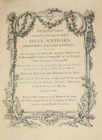
(History of Cartography, Geographic description of the Antilles): Description geographique des isles Antilles possédées par les Anglois

by Bellin, Jacques Nicolas

  • Used
  • very good
  • Hardcover
  • first
Condition
Used - Very Good
Edition
First Edition
Binding
Hardcover
Seller
Crozet, Virginia
Seller rating:
This seller has earned a 5 of 5 Stars rating from Biblio customers.
Item Price
$7,575.00
$8.50 shipping to USA

Show Details

Description:
A Paris: De l'imprimerie de Didot, 1758. This 10.5 inch quarto is in very good condition, sound hinges, 171 pp. with all 22 maps (several folding), plans and views in very good or better condition on heavy paper. Contemporary calf boards with original marbeled pastedowns, two title pages (one decorative with attribution to Bellin), "Tables des Titres" and "Table des Cartes, Plans et Vues." Six compartment, banded spine, with red, gilt title label.Triple (French), gilt fillets on front and rear boards. Bellin was the first chief hydrographic engineer of the French Hydrographic Office (see Tooley's Dictionary of Mapmakers, revised ed.). Ref: Beinecke, Lesser Antilles Collection, 215; Sabin 4553. This is an extremely nice copy.. First Edition. Full-Leather. Very Good.
Item Price
$7,575.00
$8.50 shipping to USA
(Celestial chart, lunar orbits and eclipses): Theoria Lunae, Eius Motum Per Eccentricum Et...

(Celestial chart, lunar orbits and eclipses): Theoria Lunae, Eius Motum Per Eccentricum Et Epicyclum Demonstrans

by Valk, Gerard and Schenk, Petrus [Cellarius, Andreas]

  • Used
Condition
Used
Seller
Crozet, Virginia
Seller rating:
This seller has earned a 5 of 5 Stars rating from Biblio customers.
Item Price
$2,675.00
$8.50 shipping to USA

Show Details

Description:
Amsterdam: Schenk and Valk, 1708. Very good, minimal foxing, early color (with more recent enhancement) copperplate from this 1708 (original version published in 1660 by Jansson) Schenk/Valk issue of (Andreas Cellarius') "Harmonia Macrocosmica Seu Atlas Universalis Et Novus." The striking image measures 43 x 52 cm on a sheet 51 x 60 cm. Numerous cherubim surrond the circular view, as does an outer circle of a number of signs of the zodiac. There are a couple of pinhole defects, repaired verso, with no significant loss of imate. Ref: Koeman, Atlantes Neerlandici, Cel.3..
Item Price
$2,675.00
$8.50 shipping to USA
(Old World hemispheric map with climatic zones): Hemisphaerium Orbis Antiqui, Cumzonis, Circulis,...

(Old World hemispheric map with climatic zones): Hemisphaerium Orbis Antiqui, Cumzonis, Circulis, Et Situ Populorum Diverso

by Valk, Gerard and Schenk, Petrus [Cellarius, Andreas]

  • Used
Condition
Used
Seller
Crozet, Virginia
Seller rating:
This seller has earned a 5 of 5 Stars rating from Biblio customers.
Item Price
$2,675.00
$8.50 shipping to USA

Show Details

Description:
Amsterdam: Schenk and Valk, 1708. Very good, minimal foxing, early color copperplate from this 1708 (original version published in 1660 by Jansson) Schenk/Valk issue of (Andreas Cellarius') "Harmonia Macrocosmica Seu Atlas Universalis Et Novus." The striking image measures 41 x 51 cm on a sheet 50 x 59 cm. Numerous cherubim surrond the eastern hemispheric view, which is also divided into frigid, termperate, tropical and torrid zones. There are separate armillary and habitat zonal spheres in the lower corners. Ref: Koeman, Atlantes Neerlandici, Cel.3. There are bilateral, faint water-stains in the pink circular band surrounding the map image..
Item Price
$2,675.00
$8.50 shipping to USA
(Satirical political map of Franco-Prussian War): Karte von Europa im Jahre 1870 nach einem...

(Satirical political map of Franco-Prussian War): Karte von Europa im Jahre 1870 nach einem französischen Holzschnitte

by Hadol (Paul)

  • Used
  • first
Condition
Used
Edition
First Edition Thus
Seller
Crozet, Virginia
Seller rating:
This seller has earned a 5 of 5 Stars rating from Biblio customers.
Item Price
$1,875.00
$8.50 shipping to USA

Show Details

Description:
Hamburg: Fuchs, 1914. Very good, on thin paper, with original color, folds as issued (now flattened with some archival tape repair at folds on verso). Mild foxing most evident n lower margin. These maps, often ephemeral in nature, are now all increasingly scarce. Although the date on the map is 1870, it was published by Fuchs ("Verlag von Chs. Fuchs' lith. Inst. Hamburg" in lower right margin just outside neatline), and the text in the lower margin is in both German and French. The map image measures 24 x 38 cm. on a sheet 36 x 46 cm. There is a second title within the neatline: Carte drôlatique d'Europe pour 1870.. First Edition Thus.
Item Price
$1,875.00
$8.50 shipping to USA
(Map of colonial northeastern Canada): Partie Orientale de la Nouvelle France ou du...

(Map of colonial northeastern Canada): Partie Orientale de la Nouvelle France ou du Canada...Terre-Neuve...Nouvelle Ecosse Acadie...T. Conrad Lotter Graveur et Geogr

by Lotter, Conrad (Seutter, Albrecht Carl)

  • Used
Condition
Used
Seller
Crozet, Virginia
Seller rating:
This seller has earned a 5 of 5 Stars rating from Biblio customers.
Item Price
$1,895.00
$8.50 shipping to USA

Show Details

Description:
Augusburg: Tobias Conrad Lotter and Albrecht Karl Seutter, 1756. Very good copperplate engraving with a right marginal tear not affecting image, repaired verso with archival tape. Some restoration to left margin (not affecting main image), and entire map backed with archival paper. Strong image. Small embossed stamp left lower margin (faint), with attribution to Seutter in left lower margin just below neatline. The date is approximate, and predicated on Lotter's partnership with Seutter from 1756-62. Earlier states appeared in a number of Seutter atlases. Ref: McCorkle, New England in Printed Maps, entry 730.4, p. 90. The image depicts an area from parts of Labrador to Nova Scotia. The map has outline and minimal wash color, with an elaborate, allegorical cartouche. Lotter was Seutter's son-in-law. The map image measures 58 x 50 cm..
Item Price
$1,895.00
$8.50 shipping to USA
[World Map, Bible]: A Map of all the Earth and how after the Flood it was divided among the Sons...

[World Map, Bible]: A Map of all the Earth and how after the Flood it was divided among the Sons of Noah

by Moxon, Joseph

  • Used
  • first
Condition
Used
Seller
Crozet, Virginia
Seller rating:
This seller has earned a 5 of 5 Stars rating from Biblio customers.
Item Price
$1,975.00
$8.50 shipping to USA

Show Details

Description:
Amsterdam: Visscher, Nicholas (Nicolaus), 1685. Very good, early color (perhaps some recent enhancement), few tiny worm holes, minor restoration at lower right (no image loss) and flattened center fold. Minmial browning margins. The date is approximate. Numerous biblical vignettes, some with Hebrew lettering. This was done for a Dutch bible, this one published by Visscher in Amsterday. Shirley's entry 457 is a similar map but without the Visscher imprint (and this issue does not have the tabular information in the lower central area. North America is labeled with "Japhet," and "Eden" is shown towards the cetner of the depiction of Asia. The vignettes are quite decorative. Moxon was a print and globe-maker, and he was the first tradesman to be elected to the Royal Society (online Dictionary of National Biography). The image measures 32 x 46 cm (18 x 12.5 inches), and has good margins..
Item Price
$1,975.00
$8.50 shipping to USA