Rare and Antiquarian Books
Maps and Atlases
Results 226 - 240 of 320

More Photos
Méthode simple et facile pour lever les plans, suivie d'un traité du nivellement, d'un abrégé des règles du lavis et des élémens de trigonométrie rectiligne
by LECOY, François
- Used
- near fine
- Hardcover
- Condition
- Used - Near Fine
- Edition
- First
- Binding
- Hardcover
- Seller
-
COLUMBIA, Missouri
- Item Price
-
$599.00FREE shipping to USA
Show Details
Item Price
$599.00
FREE shipping to USA

Mother of all life: A prophetic illumination
by Judith Pearl
- Used
- Paperback
- Signed
- Condition
- Used - v
- Edition
- R1998
- Binding
- Paperback
- Seller
-
Forbes Road, Pennsylvania
- Item Price
-
$395.00$4.59 shipping to USA
Show Details
Item Price
$395.00
$4.59
shipping to USA

More Photos
Ohio
by BURR, David H. (cartog.)
- Used
- near fine
- Hardcover
- Condition
- Used - Near Fine
- Binding
- Hardcover
- Seller
-
COLUMBIA, Missouri
- Item Price
-
$599.00FREE shipping to USA
Show Details
Item Price
$599.00
FREE shipping to USA

More Photos
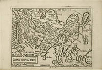
1764 ATLAS MAPS & Voyages Pluche Geography Asia Arabia Greece America Egypt
by PLUCHE, Noël Antoine
- Used
- near fine
- Hardcover
- Condition
- Used - Near Fine
- Binding
- Hardcover
- Seller
-
COLUMBIA, Missouri
- Item Price
-
$750.00FREE shipping to USA
Show Details
Item Price
$750.00
FREE shipping to USA

More Photos
Atlas de l'histoire du Consulat et de l'Empire
by THIERS, Adolphe
- Used
- near fine
- Hardcover
- Condition
- Used - Near Fine
- Binding
- Hardcover
- Seller
-
COLUMBIA, Missouri
- Item Price
-
$750.00FREE shipping to USA
Show Details
Item Price
$750.00
FREE shipping to USA

More Photos
Historical map of Nantucket, 1869.
by Ferdinand C. Ewer
- Used
- Condition
- Used
- Seller
-
Houston, Texas
- Item Price
-
$250.00$9.00 shipping to USA
Show Details
Item Price
$250.00
$9.00
shipping to USA
More Photos
Theatro del mondo.
by ORTELIUS, Abraham.
- Used
- Hardcover
- Condition
- Used
- Binding
- Hardcover
- Seller
-
Paris, France
- Item Price
-
$11,457.60$9.24 shipping to USA
Show Details
Item Price
$11,457.60
$9.24
shipping to USA

More Photos
Collection de cartes concernant les forêts, triages et bois taillés du Comté-prairie d'Eu
by ESTANCELIN, Louis
- Used
- near fine
- Hardcover
- first
- Condition
- Used - Near Fine
- Edition
- First
- Binding
- Hardcover
- Seller
-
COLUMBIA, Missouri
- Item Price
-
$1,500.00FREE shipping to USA
Show Details
Item Price
$1,500.00
FREE shipping to USA

More Photos
Map of France - 1842
- Used
- Condition
- Used
- Seller
-
Cashiers, North Carolina
- Item Price
-
$225.00FREE shipping to USA
Show Details
Item Price
$225.00
FREE shipping to USA
![RUSSIA IN EUROPE [Original Hand-colored Lithographed Map]](https://d3525k1ryd2155.cloudfront.net/h/838/461/1485461838.0.m.jpg)
More Photos
RUSSIA IN EUROPE [Original Hand-colored Lithographed Map]
by Mitchell, Samuel Augustus
- Used
- very good
- Condition
- Used - Very Good
- Edition
- Original
- Seller
-
Williamsburg, Virginia
- Item Price
-
$120.00$6.50 shipping to USA
Show Details
Item Price
$120.00
$6.50
shipping to USA

More Photos
Appletons' southern and western travellers' guide : with new and authentic maps, illustrating those divisions of the country ; and containing sectional maps of the Mississippi and Ohio rivers ; with plans of cities, views, etc
by WILLIAMS, Wellington
- Used
- near fine
- Hardcover
- Condition
- Used - Near Fine
- Binding
- Hardcover
- Seller
-
COLUMBIA, Missouri
- Item Price
-
$750.00FREE shipping to USA
Show Details
Item Price
$750.00
FREE shipping to USA
More Photos
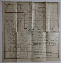
The Missouri Land & Live Stock Co. Have for Sale a Large Amount of Fine Fruit & Agricultural Lands in Stone and Christian Counties MO. At Low Prices and on Easy Terms
by John M. Purdy, Manager
- Used
- very good
- Paperback
- Condition
- Used - Very Good
- Binding
- Paperback
- Seller
-
Bloomington, Indiana
- Item Price
-
$700.00FREE shipping to USA
Show Details
Item Price
$700.00
FREE shipping to USA

More Photos
Delta.
by Aly, Islam.
- Used
- Hardcover
- Condition
- Used
- Edition
- Edition of 50 + 5 proofs
- Binding
- Hardcover
- Seller
-
Hoover, Alabama
- Item Price
-
$1,800.00$14.35 shipping to USA
Show Details
Item Price
$1,800.00
$14.35
shipping to USA

More Photos
Atlas of the Lewis & Clark Expedition
- Used
- Hardcover
- first
- Condition
- Used
- Edition
- First Edition
- Binding
- Hardcover
- Seller
-
San Rafael, California
- Item Price
-
$115.00$4.75 shipping to USA
Show Details
Item Price
$115.00
$4.75
shipping to USA
![Nouveau Voyage aux Isles de l'Amerique, [SIX VOLUME SET] contenant L'Histoire Naturelle...](https://d3525k1ryd2155.cloudfront.net/h/467/743/1569743467.0.m.jpg)
More Photos
Nouveau Voyage aux Isles de l'Amerique, [SIX VOLUME SET] contenant L'Histoire Naturelle de ces Pays, l'Origine, le Moeurs, la Religion & le Gouvernement des Habitans anciens & modernes. Les Guerres & les Evenemens singuliers qui y sont arrivez pendant le long sejour que l'Auteur y a fait. Le Commerce & les Manufactures qui y sont etablies, & les moyens de les augmenter. Avec une Description exacte & curieuse de toutes ces Isles. Ouvrage enrichi de plus de cent Cartes, Plans, & Figures en Tailles - douches.
by Labat, Jean-Baptiste
- Used
- very good
- Hardcover
- first
- Condition
- Used - Very Good
- Edition
- First Edition First Printing
- Binding
- Hardcover
- Seller
-
Greensboro, North Carolina
- Item Price
-
$2,500.00$3.99 shipping to USA
Show Details
Item Price
$2,500.00
$3.99
shipping to USA
